

Here you can study for the exam. Look up keywords and learn definitions about all kind of subjects.
More subjects
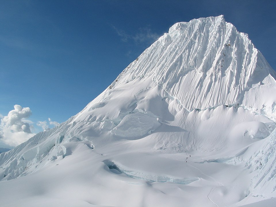
Alpamayo (possibly from Quechua allpa earth, mayu river, 'earth river') or Shuyturaju (possibly from Ancash Quechua huytu, shuytu oblong, slim and long, Quechua rahu snow, ice, mountain covered in snow) is one of the most conspicuous peaks in the Cordillera Blanca of the Peruvian Andes. Alpamayo Creek originates northwest of it. The Alpamayo lies next to the slightly higher Quitaraju. In July 1966, the German magazine 'Alpinismus', published a photo of Alpamayo taken by American photographer Leigh Ortenburger accompanied by an article on a survey among mountaineering experts, who chose Alpamayo as 'The Most Beautiful Mountain in the World'. (Source: Wikipedia.org, CC BY-SA)
 © Wikimedia.org/Brad Mering, CC0
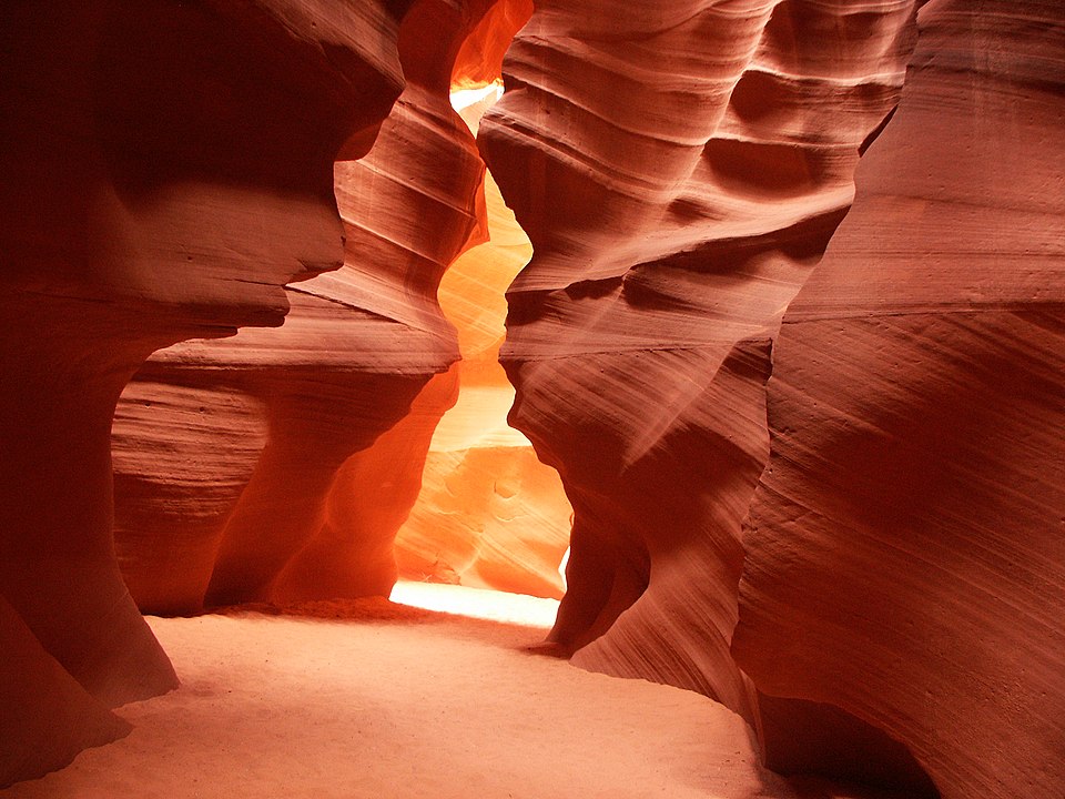
Navajo Upper Antelope Canyon is a slot canyon in the American Southwest, on Navajo land east of Lechee, Arizona. It includes six separate, scenic slot canyon sections on the Navajo Reservation, referred to as Upper Antelope Canyon (or The Crack), Rattle Snake Canyon, Owl Canyon, Mountain Sheep Canyon, Canyon X and Lower Antelope Canyon (or The Corkscrew). It is the primary attraction of Lake Powell Navajo Tribal Park, along with a hiking trail to Rainbow Bridge National Monument. The Navajo name for Upper Antelope Canyon is Tsé bighánílíní, which means 'the place where water runs through the (Slot Canyon) rocks'. Lower Antelope Canyon is Hazdistazí (called 'Hasdestwazi' by the Navajo Parks and Recreation Department), or 'spiral rock arches'. Both are in the LeChee Chapter of the Navajo Nation. They are accessible by Navajo guided tour only. (Source: Wikipedia.org, CC BY-SA)
 © Wikimedia.org/Meckimac, CC BY-SA
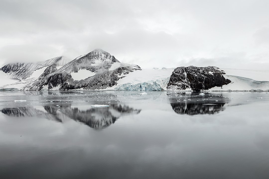
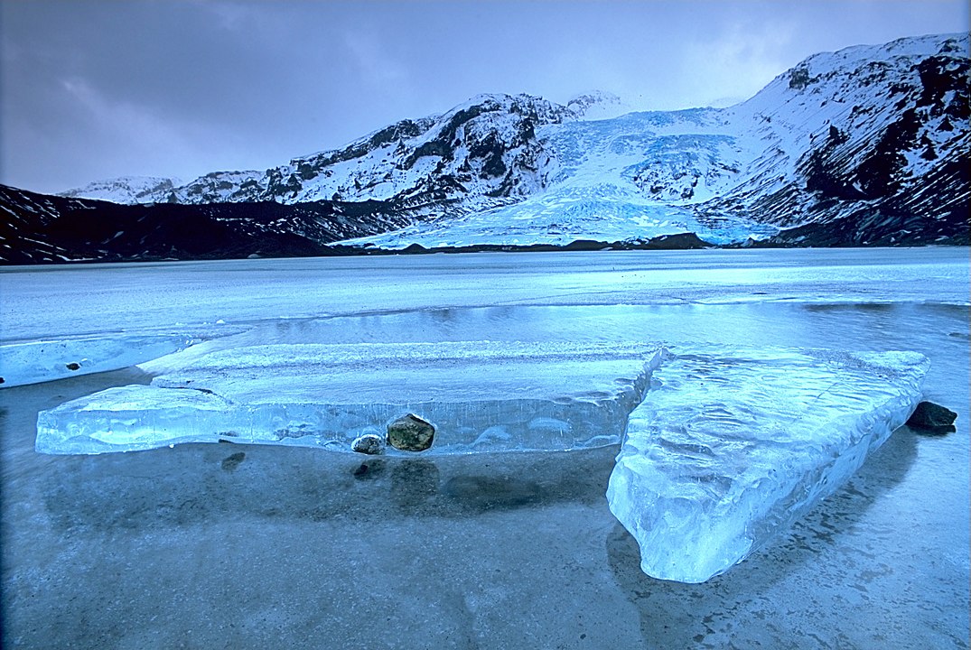
Arena Glacier is a glacier on Trinity Peninsula, the northernmost region of the Antarctic Peninsula. The glacier is 3 miles (5 km) long and flows northeast from Mount Taylor into Hope Bay, 2 miles (3 km) southwest of Sheppard Point. The Falkland Islands Dependencies Survey mapped the area in 1948 and again in 1955. Due to its flat ice floor on the upper half, they named it Arena Glacie, which was surrounded by the steep slopes of the Twin Peaks, Mount Taylor and Blade Ridge, resembling an arena. (Source: Wikipedia.org, CC BY-SA)
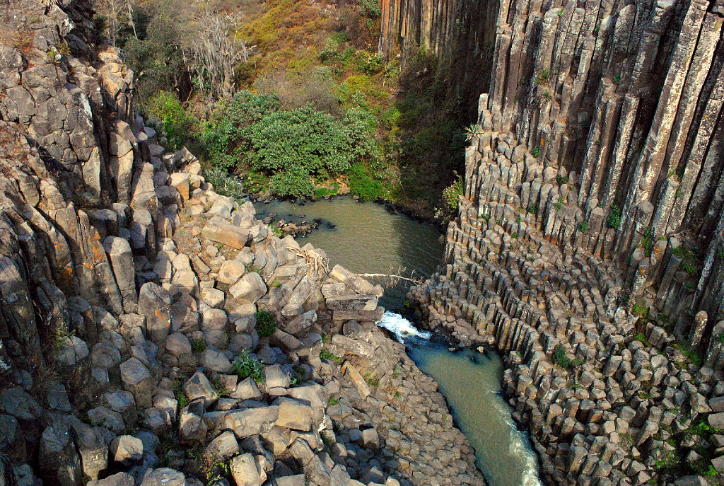
The Basaltic Prisms of Santa María Regla are tall columnar joints of basalt rock near Huasca de Ocampo in the Mexican state of Hidalgo, that line a ravine through which water runs from the San Antonio Dam. This ravine area was part of the Santa María Regla Hacienda and was first promoted by Alexander von Humboldt in 1803. The canyon walls, called the Barranca de Santa María Regla, are lined by polygonal columns between 30 and 50 metres (98 and 164 ft) high, with five or six sides each. The basalt columns were created by the slow cooling of volcanic lava. The visible columns are backed by even more polygonal basalt columns. There are two waterfalls. The higher one has its water supplemented by diversions from nearby dams. The lower one is called the Cascada de la Rosa. The natural canyon has been modified by the addition of stairs, walkways and hanging bridges for easier access. (Source: Wikipedia.org, CC BY-SA)
 © Wikimedia.org/Bolliot, CC BY-SA
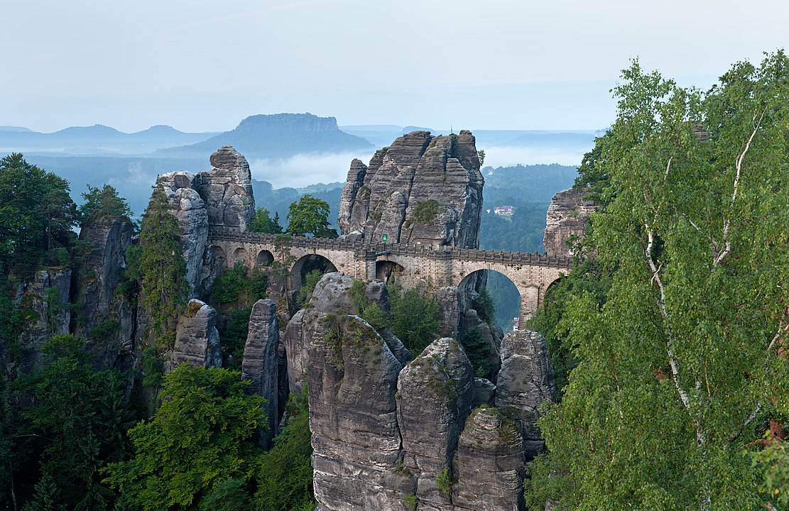
The Bastei is a rock formation rising 194 metres above the Elbe River in the Elbe Sandstone Mountains of Germany. Reaching a height of 305 metres above sea level, the jagged rocks of the Bastei were formed by water erosion over one million years ago. They are situated near Rathen, not far from Pirna southeast of the city of Dresden, and are the major landmark of the Saxon Switzerland National Park. They are also part of a climbing and hiking area that extends over the borders into the Bohemian Switzerland (Czech Republic). The Bastei has been a tourist attraction for over 200 years. In 1824, a wooden bridge was constructed to link several rocks for the visitors. This bridge was replaced in 1851 by the present Bastei Bridge made of sandstone. The rock formations and vistas have inspired numerous artists, among them Caspar David Friedrich ('Felsenschlucht') (Source: Wikipedia.org, CC BY-SA)
The Bay of Kotor (Montenegrin and Serbian: Бока которска / Boka kotorska, Italian: Bocche di Cattaro), also known as the Boka, is a winding bay of the Adriatic Sea in southwestern Montenegro and the region of Montenegro concentrated around the bay. It is also the southernmost part of the historical region of Dalmatia. The bay has been inhabited since antiquity. Its well-preserved medieval towns of Kotor, Risan, Tivat, Perast, Prčanj and Herceg Novi, along with their natural surroundings, are major tourist attractions. The Natural and Culturo-Historical Region of Kotor was designated a UNESCO World Heritage Site in 1979. Its numerous Orthodox and Catholic churches and monasteries attract numerous religious pilgrims and other visitors. (Source: Wikipedia.org, CC BY-SA)
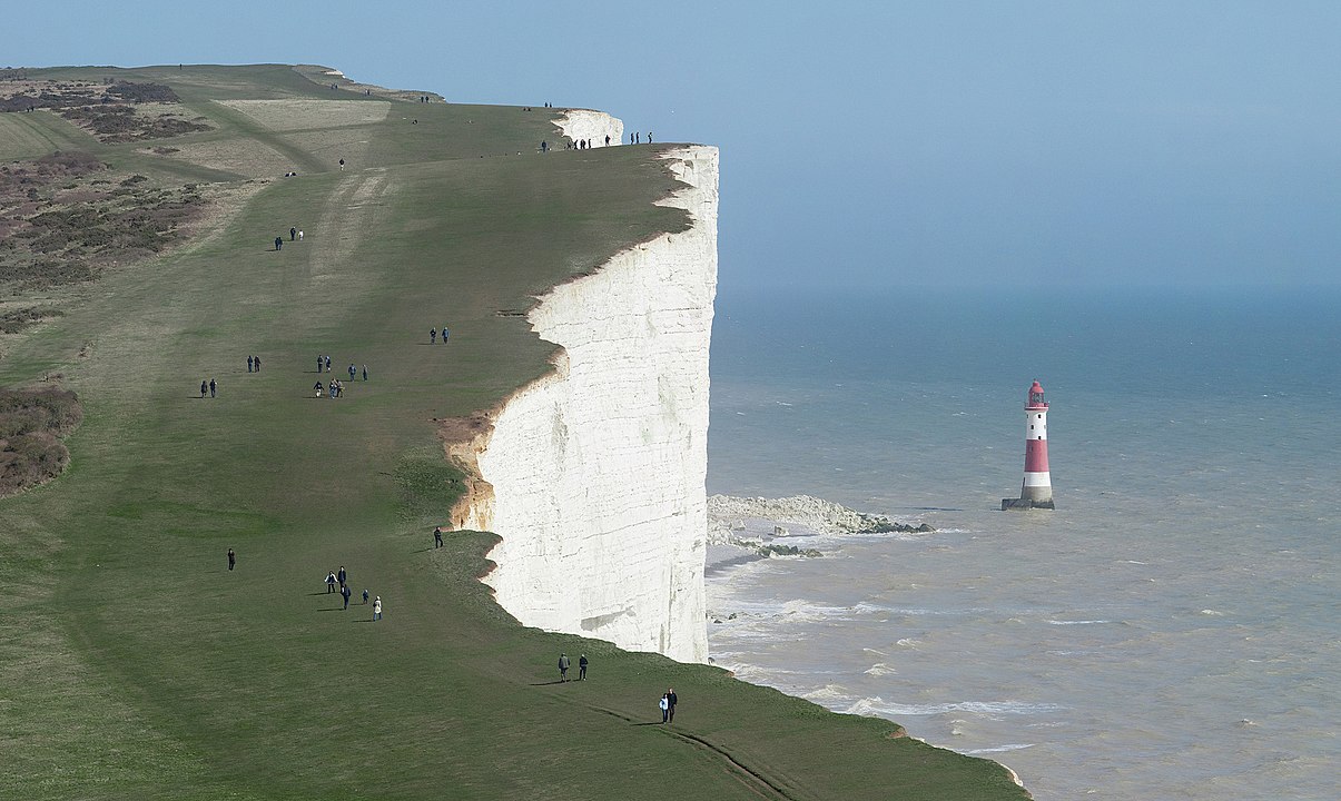
Beachy Head is a chalk headland in East Sussex, England. It is situated close to Eastbourne, immediately east of the Seven Sisters. Beachy Head is located within the administrative area of Eastbourne Borough Council which owns the land, forming part of the Eastbourne Downland Estate. The cliff is the highest chalk sea cliff in Britain, rising to 162 m (531 ft) above sea level. The peak allows views of the south east coast towards Dungeness in the east, and to the Isle of Wight in the west. The chalk was formed in the Late Cretaceous epoch, between 66 and 100 million years ago, when the area was under the sea. During the Cenozoic Era, the chalk was uplifted (see Cenozoic Era). When the last ice age ended, sea levels rose and the English Channel formed, cutting into the chalk to form the dramatic cliffs along the Sussex coast. (Source: Wikipedia.org, CC BY-SA)
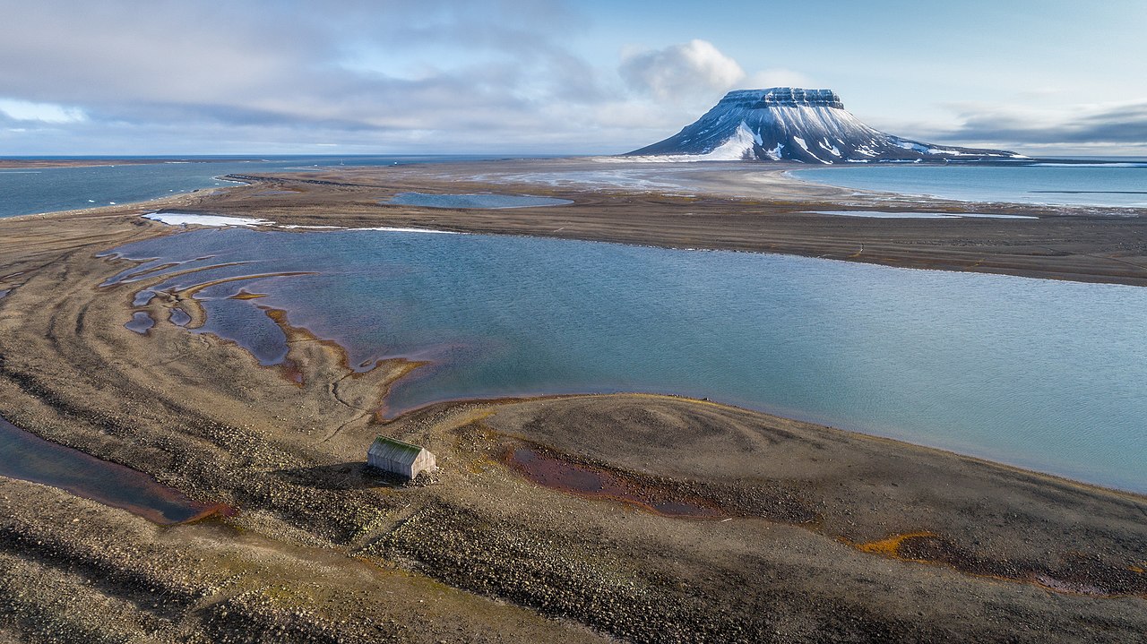
Bell Island (Russian: Остров Белл) is a small island in the south-west of the Franz Josef Land archipelago in Arkhangelsk Oblast, Russia. The island was named by the English explorer Benjamin Leigh Smith for its bell-shaped mountain which rises steeply from the island's southern coast with the Barents Sea. (Source: Wikipedia.org, CC BY-SA)
 © Wikimedia.org/Timinilya, CC BY-SA
Bryce Canyon National Park (/braɪs/) is an American national park located in southwestern Utah. The major feature of the park is Bryce Canyon, which despite its name, is not a canyon, but a collection of giant natural amphitheaters along the eastern side of the Paunsaugunt Plateau. Bryce is distinctive due to geological structures called hoodoos, formed by frost weathering and stream erosion of the river and lake bed sedimentary rocks. The red, orange, and white colors of the rocks provide spectacular views for park visitors. Bryce Canyon National Park is much smaller and sits at a much higher elevation than nearby Zion National Park. The rim at Bryce varies from 8,000 to 9,000 feet (2,400 to 2,700 m). (Source: Wikipedia.org, CC BY-SA)
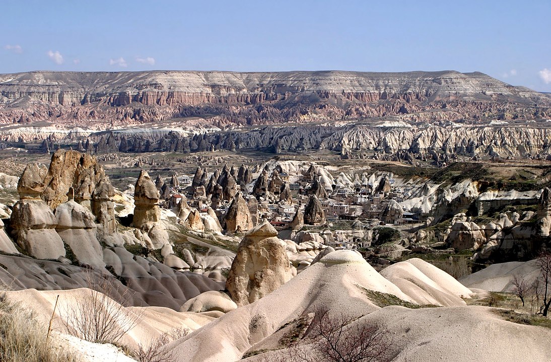
Cappadocia (/kæpəˈdoʊʃəˌ -ˈdoʊkiə/; Turkish: Kapadokya) is a historical region in Central Anatolia, Turkey. It is largely in the provinces of Nevşehir, Kayseri, Aksaray, Kırşehir, Sivas and Niğde. According to Herodotus, in the time of the Ionian Revolt (499 BC), the Cappadocians were reported as occupying a region from Mount Taurus to the vicinity of the Euxine (Black Sea). Cappadocia, in this sense, was bounded in the south by the chain of the Taurus Mountains that separate it from Cilicia, to the east by the upper Euphrates, to the north by Pontus, and to the west by Lycaonia and eastern Galatia. The name, traditionally used in Christian sources throughout history, continues in use as an international tourism concept to define a region of exceptional natural wonders, in particular characterized by fairy chimneys and a unique historical and cultural heritage. (Source: Wikipedia.org, CC BY-SA)
 © Wikimedia.org/Brocken Inaglory, CC BY-SA
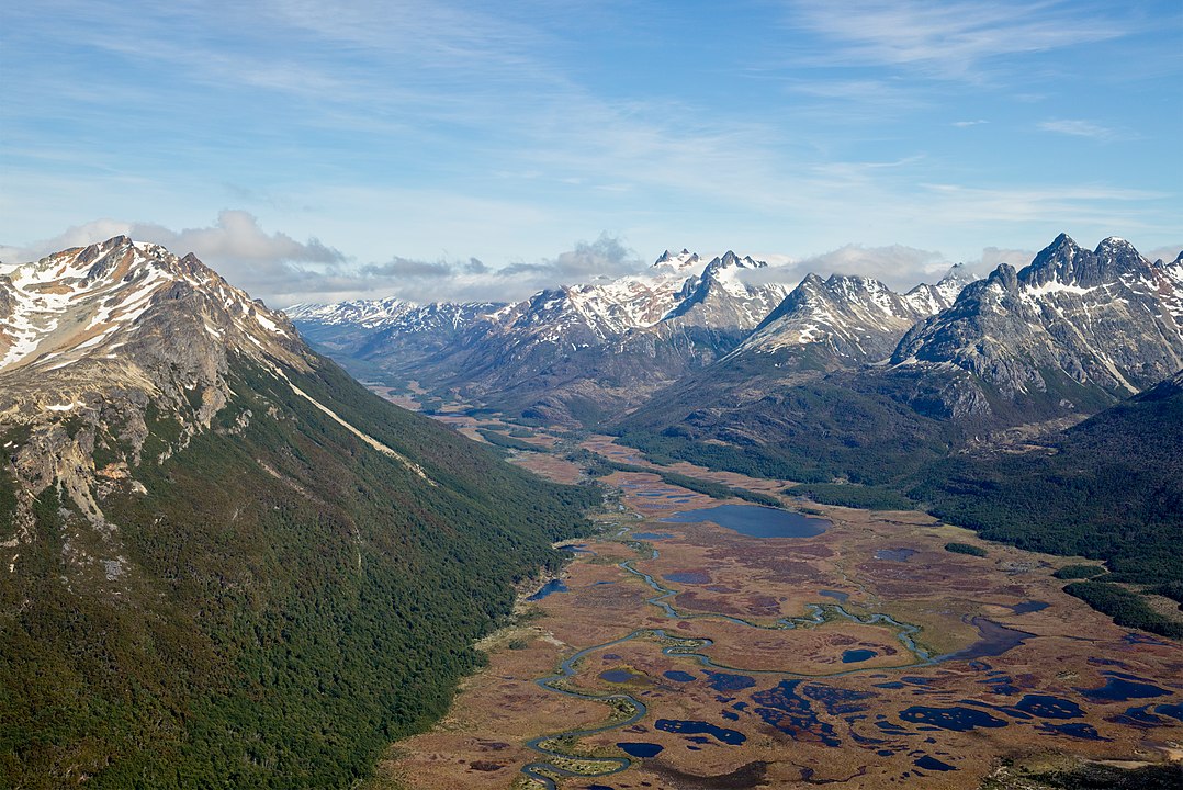
The Carbajal Valley (Spanish: Valle Carbajal) is a valley in the Fuegian Andes of southern Tierra del Fuego Province, Argentina. The Carbajal valley is approximately 20 kilometres (12 mi) long, running west to east, between the Alvear mountain range to the north and the Vinciguerra range to the south. Andes peak heights in the region are generally less than 1,250 metres (4,100 ft) above sea level. (Source: Wikipedia.org, CC BY-SA)
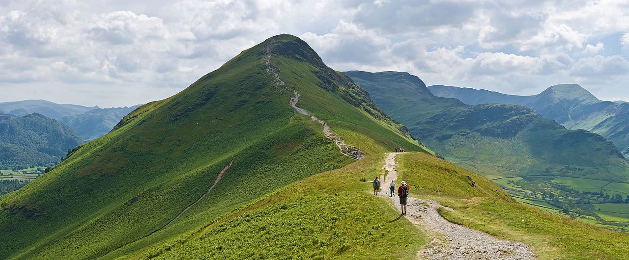
Cat Bells is a fell in the English Lake District in the county of Cumbria. It has a height of 451 metres (1,480 ft) and is one of the most popular fells in the area. It is situated on the western shore of Derwentwater within three miles (five kilometres) of the busy tourist town of Keswick. Its distinctive shape catches the attention of many visitors to the Lakes who feel compelled to climb to the summit after seeing it from the viewpoint of Friars' Crag on the opposite side of Derwentwater. (Source: Wikipedia.org, CC BY-SA)
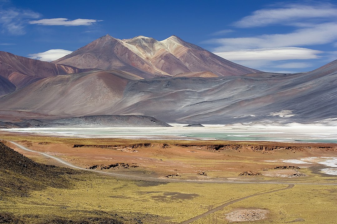
Cerros de Incahuasi is a mountain with several summits located in the Antofagasta Region of Chile, near Sico Pass. The present–day mountain is the result of the partial collapse of an ancient volcanic edifice. The Incahuasi Sur volcano in this range was active 10.5 million years ago. It is associated with a volcanic belt and fault that extends southeastward from Incahuasi Sur, the Calama–Olacapato–El Toro fault. (Source: Wikipedia.org, CC BY-SA)
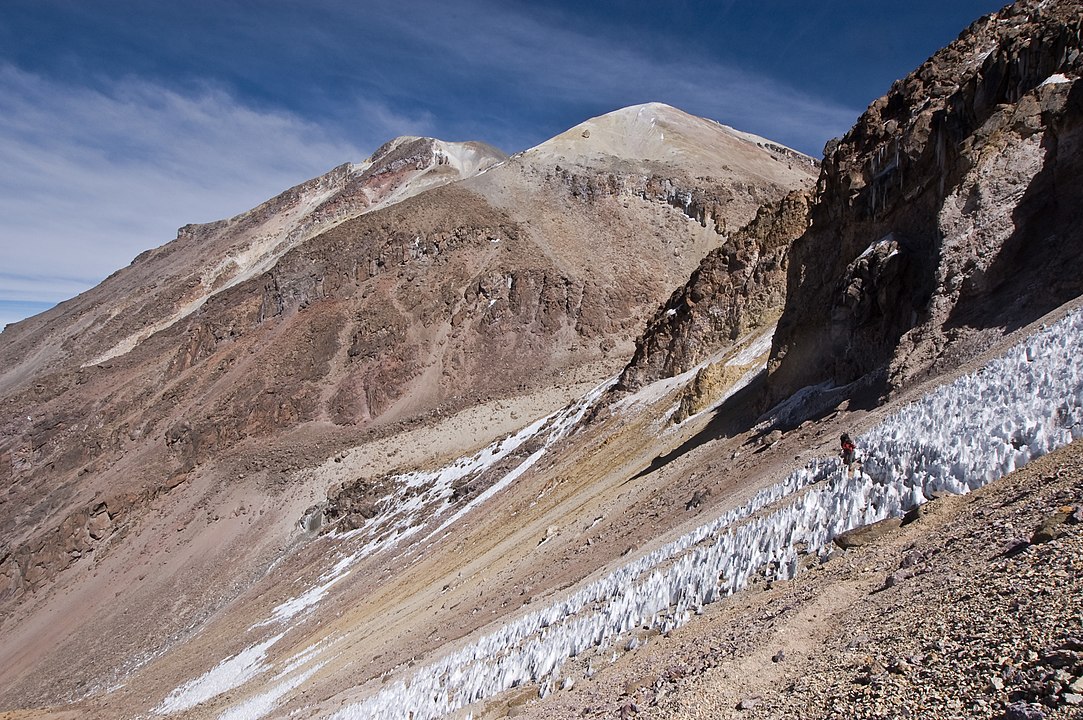
Chachani is a volcanic group in southern Peru, 22 kilometres (14 mi) northwest of the city of Arequipa. Part of the Central Volcanic Zone of the Andes, it is 6,057 metres (19,872 ft) above sea level. It consists of several lava domes and individual volcanoes such as Nocarane, along with lava shields such as the Airport Domes. Underneath Chachani lies a caldera. During the Pliocene and early Pleistocene, the volcanic group produced large ignimbrites such as the La Joya, Arequipa Airport and Yura Tuff ignimbrites; afterwards the volcanic group proper grew in the caldera until about 56,500 years ago. There have not been any eruptions during historical time, but the volcano is considered to be only dormant and due to its closeness to the city of Arequipa is considered high risk. (Source: Wikipedia.org, CC BY-SA)
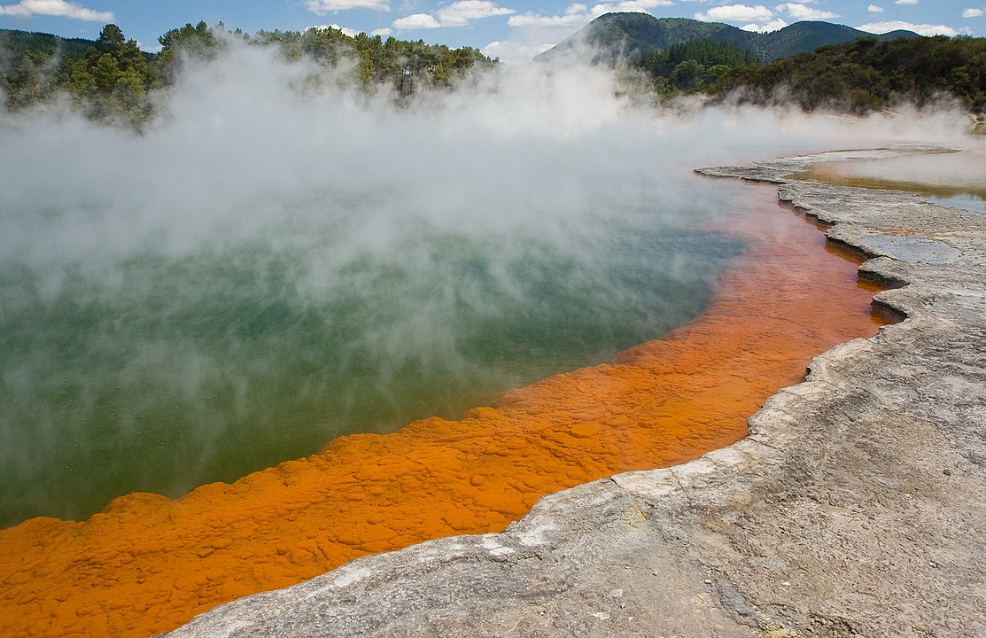
Champagne Pool is a prominent geothermal feature within the Waiotapu geothermal area in the North Island of New Zealand. The terrestrial hot spring is located about 30 km (20 mi) southeast of Rotorua and about 50 km (30 mi) northeast of Taupo. The name Champagne Pool is derived from the abundant efflux of carbon dioxide (CO2), similar to a glass of bubbling champagne. The hot spring was formed 900 years ago by a hydrothermal eruption, which makes it in geological terms a relatively young system. Its crater is about 65 m (213 ft) in diameter with a maximum depth around 62 m (203 ft) and is filled with an estimated volume of 50,000 m3 (1,800,000 cu ft) of geothermal fluid. (Source: Wikipedia.org, CC BY-SA)
Chugach State Park covers 495,204 acres (2,004 square kilometers) covering a hilly region immediately east of Anchorage, in south-central Alaska. Established by legislation signed into law on August 6, 1970, by Alaska Governor Keith Miller, this state park was created to provide recreational opportunities, protect the scenic value of the Chugach Mountains and other geographic features, and ensure the safety of the water supply for Anchorage. The park, managed by Alaska State Parks, is the third-largest state park in the United States, and consists of geographically disparate areas each with different attractions and facilities. Only Anza-Borrego Desert State Park in California and Wood-Tikchik State Park in western Alaska are larger. Though primarily in the Municipality of Anchorage, a small portion of the park north of the Eklutna Lake area in the vicinity of Pioneer Peak lies within the Matanuska-Susitna Borough. (Source: Wikipedia.org, CC BY-SA)
The Cirque de Gavarnie is a cirque in the central Pyrenees, in Southwestern France, close to the border of Spain. It is within the commune of Gavarnie, the department of Hautes-Pyrénées, and the Pyrénées National Park. Major features of the cirque are La Brèche de Roland (English: Roland's Pass) and the Gavarnie Falls. It was described by Victor Hugo as 'the Colosseum of nature' due to its enormous size and horseshoe shape resembling an ancient amphitheatre. The cirque was inscribed on the UNESCO World Heritage List in 1997 as part of the Pyrénées – Mont Perdu World Heritage Site. The cirque is 800 m wide (on the deepest point) and about 3,000 m wide at the top. The rock walls that surround it are up to 1,500 metres (4,900 ft) above the floor of the Cirque. (Source: Wikipedia.org, CC BY-SA)
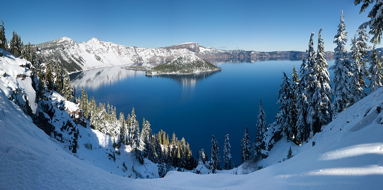
Crater Lake (Klamath: Giiwas) is a volcanic crater lake in south-central Oregon in the western United States. It is the main feature of Crater Lake National Park and is famous for its deep blue color and water clarity. The lake partly fills a 2,148-foot-deep (655 m) caldera that was formed around 7,700 (± 150) years ago by the collapse of the volcano Mount Mazama. No rivers flow into or out of the lake; the evaporation is compensated for by rain and snowfall at a rate such that the total amount of water is replaced every 250 years.[citation needed] With a depth of 1,949 feet (594 m), the lake is the deepest in the United States. In the world, it ranks ninth for maximum depth, and third for mean (average) depth. (Source: Wikipedia.org, CC BY-SA)
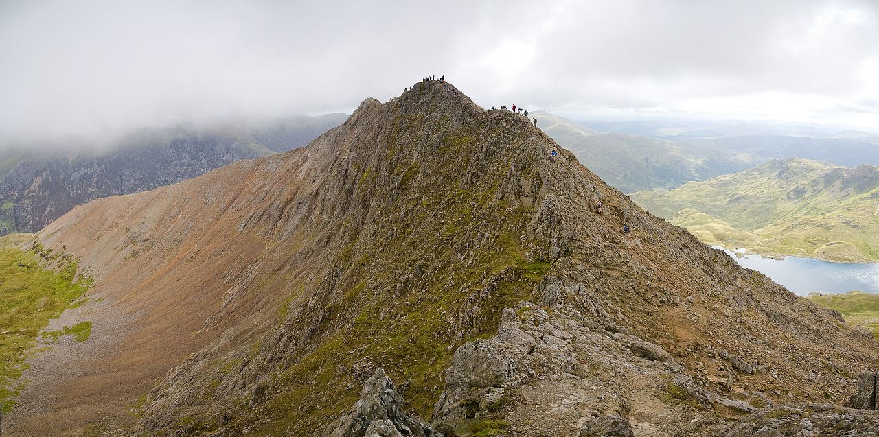
Crib Goch is described as a 'knife-edged' arête in the Snowdonia National Park in Gwynedd, Wales. The name means 'red ridge' in the Welsh language. The highest point on the arête is 923 metres (3,028 ft) above sea level. All routes which tackle Crib Goch are considered mountaineering routes in winter or scrambles in summer—meaning that they must cross 'graded territory' as defined in Steve Ashton's Scrambles in Snowdonia. The easiest of these lines (the ‘bad step’ part of the route) is given a scrambling grade of Grade 1 (the most difficult being Grade 3—routes more difficult than Grade 3 are considered rock climbs). (Source: Wikipedia.org, CC BY-SA)
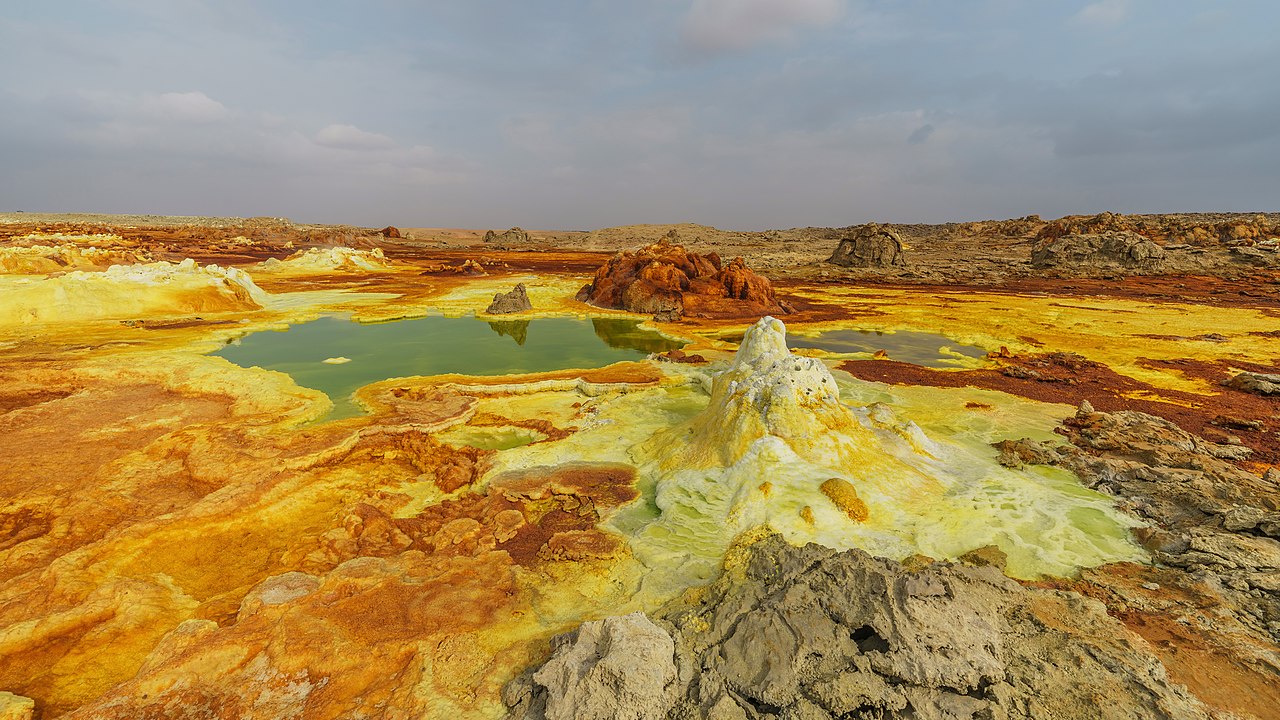
Dallol is a unique, terrestrial hydrothermal system around a cinder cone volcano in the Danakil Depression, northeast of the Erta Ale Range in Ethiopia. It is known for its unearthly colors and mineral patterns, and the very acidic fluids that discharge from its hydrothermal springs. Dallol mountain has an area of about 3 by 1.5 km (1.9 by 0.9 mi), and rises about 60 m (196.9 ft) above the surrounding salt plains. A circular depression near the centre is probably a collapsed crater. The southwestern slopes have water-eroded salt canyons, pillars, and blocks. There are numerous saline springs and fields of small fumaroles. (Source: Wikipedia.org, CC BY-SA)
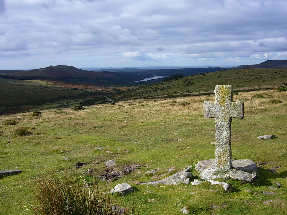
The Dartmoor crosses are a series of stone crosses found in Dartmoor National Park in the centre of Devon, England. Many of them are old navigational aids, needed because of the remoteness of the moorland and its typically bad weather. Some mark medieval routes between abbeys. Other crosses were erected as memorials, for prayer, as town or market crosses, in churchyards, and as boundary markers. The crosses were erected over a long period of time, some as recently as 100 years ago, the earliest probably almost 1,000 years ago. In 2005, the Dartmoor National Park Authority had an ongoing project to microchip the most vulnerable of its granite artifacts, including crosses, to deter theft and aid the recovery of any that might be stolen. (Source: Wikipedia.org, CC BY-SA)
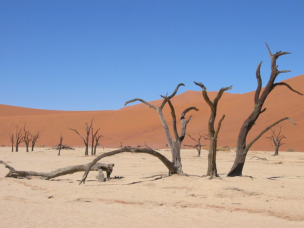
Deadvlei is a white clay pan located near the more famous salt pan of Sossusvlei, inside the Namib-Naukluft Park in Namibia. Also written DeadVlei or Dead Vlei, its name means 'dead marsh' (from English dead, and Afrikaans vlei, a lake or marsh in a valley between the dunes). The pan also is referred to as 'Dooie Vlei' which is the Afrikaans name. There are many references to the site on the Internet, its name often being translated erroneously in terms such as 'dead valley'; a vlei is not a valley (which in Afrikaans is 'vallei'). Nor is the site a valley; the pan is a desiccated vlei. Dead Vlei has been claimed to be surrounded by the highest sand dunes in the world, the highest reaching 300–400 meters (350m on average, named 'Big Daddy' or 'Crazy Dune'), which rest on a sandstone terrace. (Source: Wikipedia.org, CC BY-SA)
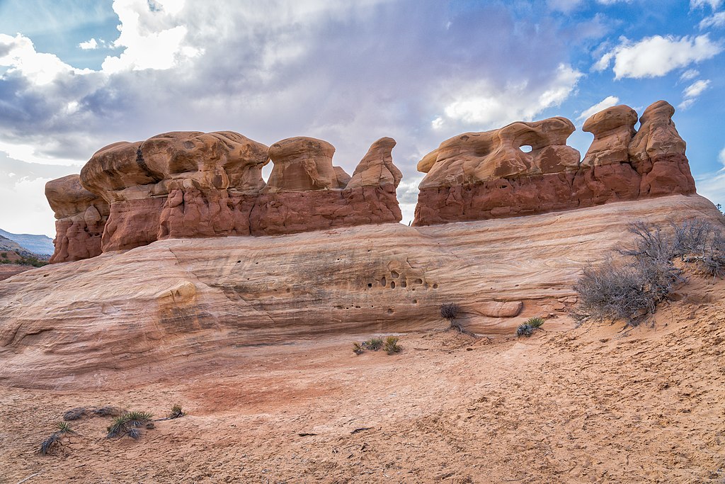
Devils Garden is an area of Arches National Park, located near Moab, Utah, United States, that features a series of rock fins and arches formed by erosion. The Devils Garden Trail, including more primitive sections and spurs, meanders through the area for 7.2 mi (11.6 km). The trailhead leads directly to Landscape Arch after a 0.8 mi (1.3 km) outbound hike, while Tunnel Arch and Pine Tree Arch can be seen on spur trails on the way to Landscape Arch. Several other arches, including Partition, Navajo, Double O, and Private Arch, as well as the Dark Angel monolith and Fin Canyon, are accessed via the primitive loop trail and its spurs. Wall Arch, before its collapse in 2008, was also located in Devils Garden just north of Landscape Arch. Black Arch is visible as a dark outline from the primitive trail and can be approached via an unmarked sidetrack. (Source: Wikipedia.org, CC BY-SA)
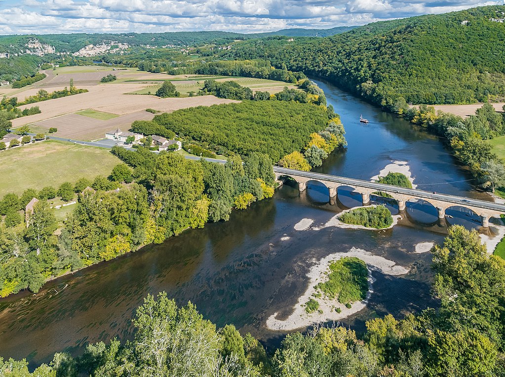
The Dordogne (French pronunciation: [dɔʁdɔɲ] ; Occitan: Dordonha) is a river in south-central and southwest France. It is 483.1 km (300.2 mi) long. The Dordogne and its watershed were designated Biosphere Reserve by UNESCO on July 11 2012. The river rises on the flanks of the Puy de Sancy at 1,885 metres (6,184 ft) above sea level in the mountains of Auvergne, from the confluence of two small torrents above the town of Le Mont-Dore: the Dore and the Dogne. It flows generally west about 500 kilometres (310 mi) through the Limousin and Périgord regions before flowing into the Gironde, its common estuary with the Garonne, at the Bec d'Ambès ('Ambès beak'), north of the city of Bordeaux. (Source: Wikipedia.org, CC BY-SA)
Durdle Door (sometimes written Durdle Dor) is a natural limestone arch on the Jurassic Coast near Lulworth in Dorset, England. It is privately owned by the Weld Family who own the Lulworth Estate, but it is also open to the public. The form of the coastline around Durdle Door is controlled by its geology—both by the contrasting hardnesses of the rocks, and by the local patterns of faults and folds. The arch has formed on a concordant coastline where bands of rock run parallel to the shoreline. The rock strata are almost vertical, and the bands of rock are quite narrow. Originally a band of resistant Portland limestone ran along the shore, the same band that appears one mile along the coast forming the narrow entrance to Lulworth Cove. Behind this is a 120-metre (390 ft) band of weaker, easily eroded rocks, and behind this is a stronger and much thicker band of chalk, which forms the Purbeck Hills. These steeply dipping rocks are part of the Lulworth crumple, itself part of the broader Purbeck Monocline, produced by the building of the Alps during the mid-Cenozoic. (Source: Wikipedia.org, CC BY-SA)
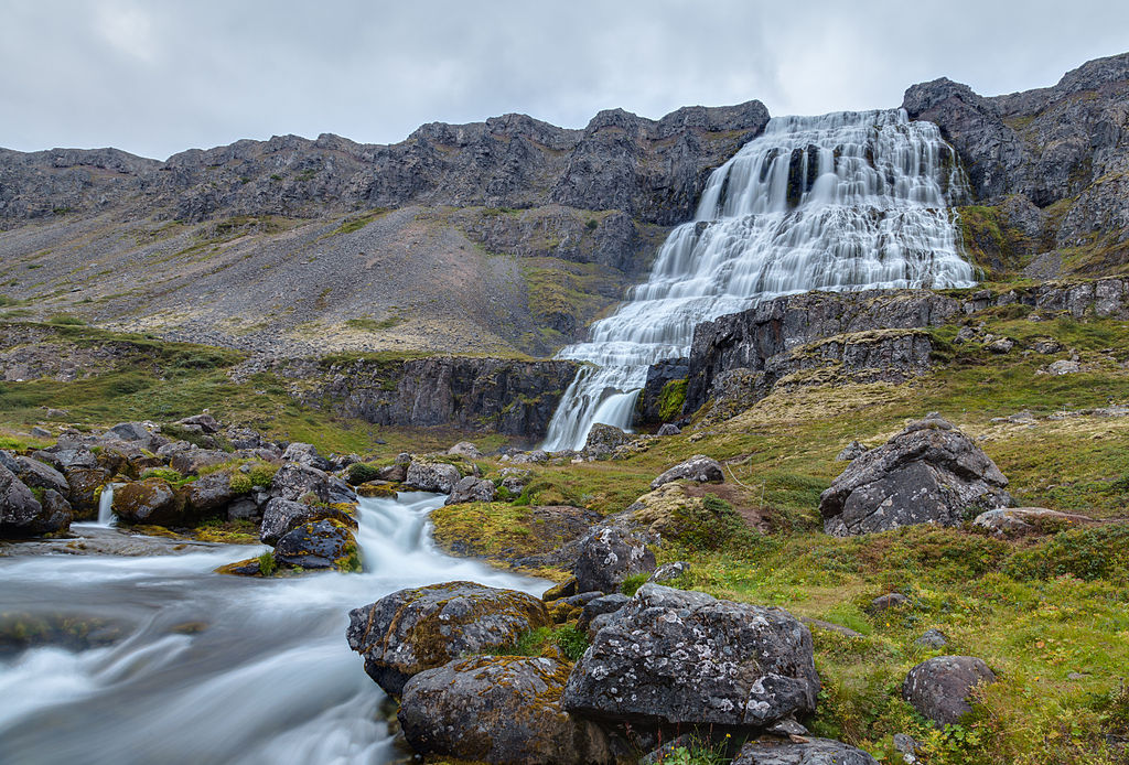
Dynjandi (Icelandic pronunciation: [ˈtɪnjantɪ], also known as Fjallfoss [ˈfjatl̥ˌfɔsː]) is a waterfall located in Arnarfjörður in the Westfjords region of Iceland. It is the largest waterfall in the Westfjords and has a total height of 100 metres (330 ft). Below it are five other waterfalls: Háifoss, Úðafoss, Göngufoss, Hundafoss and Bæjarfoss. Dynjandi and other waterfalls in Dynjandisá and their surroundings were protected as natural monuments in 1981. Dynjandisheiði is a mountain pass over the falls that contains the first-built car-accessible road to Ísafjörður. (Source: Wikipedia.org, CC BY-SA)
Ein Avdat (Hebrew: עין עבדת) or Ein Ovdat is a canyon in the Negev Desert of Israel, south of Kibbutz Sde Boker. Archaeological evidence shows that Ein Avdat was inhabited by Nabateans and Catholic monks. Numerous springs at the southern opening of the canyon empty into deep pools in a series of waterfalls. The water emerges from the rock layers with salt-tolerant plants like Poplar trees and Atriplexes growing nearby. Ein is Hebrew and Arabic for spring or water source. Avdat derives from the nearby city of Avdat that stood south of the canyon. Avdat was named after the Nabataean King Obodas I who, according to tradition, was buried there. (Source: Wikipedia.org, CC BY-SA)
 © Wikimedia.org/CarmelH1, CC BY-SA
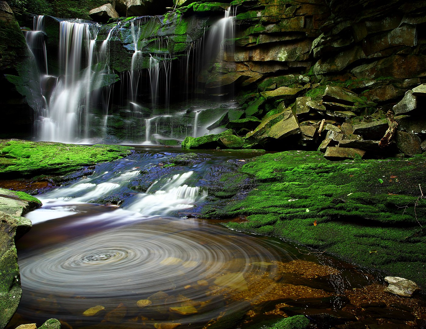
The Elakala Falls are a series of four waterfalls of Shays Run as it descends into the Blackwater Canyon in West Virginia. They are within Blackwater Falls State Park and are quite popular among photographers, with the ease of access for the first waterfall, and the relatively low traffic of the other waterfalls in the series.: 219 The first of the series of waterfalls is 35 feet (11 m) in height and is easily accessible from park trails. It is the second most popular waterfall in the park. From the official Elakala trail there is a bridge over the top of the first waterfall offering easy access and views.: 219 The remaining three waterfalls of the series are progressively more difficult to access, and have no official marked trails to them. The gorge is nearly 200 feet deep at this section accounting for the difficulty of the descent to the lower waterfalls of the series. (Source: Wikipedia.org, CC BY-SA)
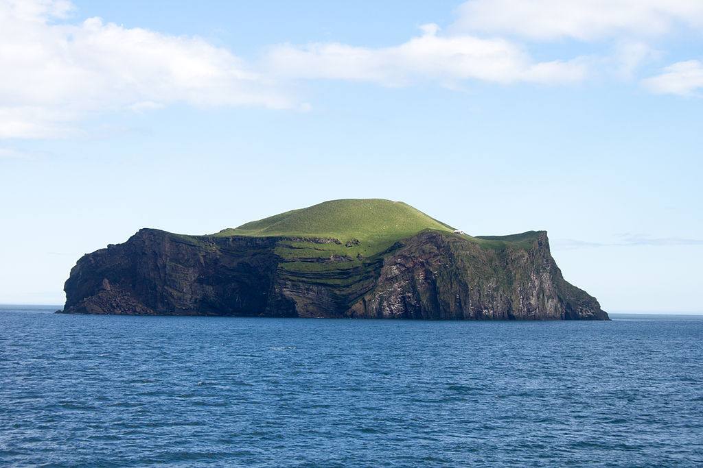
Elliðaey (Icelandic pronunciation: [ˈɛtlɪːðaˌeiː]; or Ellirey [ˈɛtlɪrˌeiː]) is a small island south of Iceland. It is the most northeastern of the Vestmannaeyjar (Westman Islands), an archipelago consisting of 15 to 18 islands and assorted smaller rocks. The island has a size of 0.45 km2 (110 acres; 45 hectares), making it the third-largest island in the archipelago. It has no permanent population and is not home to much wildlife except for an abundance of puffins. The larger and nicer of two buildings on the island is a hunting lodge, built in 1953 by the Elliðaey Hunting Association. There also exists an old storage hut and workshop built into the hill across from the lodge, it may have been used by biologists to store equipment. The lodge is often referred to as the 'world's loneliest house' on social media. (Source: Wikipedia.org, CC BY-SA)
 © Wikimedia.org/Szilas, CC0
The Engadin or Engadine (Romansh: Engiadina; German: Engadin; Italian: Engadina; French: Engadine) is a long high Alpine valley region in the eastern Swiss Alps in the canton of Graubünden in southeasternmost Switzerland with about 25,000 inhabitants. It follows the route of the Inn (Romansh: En) from its headwaters at Maloja Pass in the southwest running roughly northeast until the Inn flows into Austria, little less than one hundred kilometers downstream. The En/Inn subsequently flows at Passau into the Danube, making it the only Swiss river to drain into the Black Sea. The Engadine is protected by high mountain ranges on all sides and is famous for its sunny climate, beautiful landscapes and outdoor activities. (Source: Wikipedia.org, CC BY-SA)
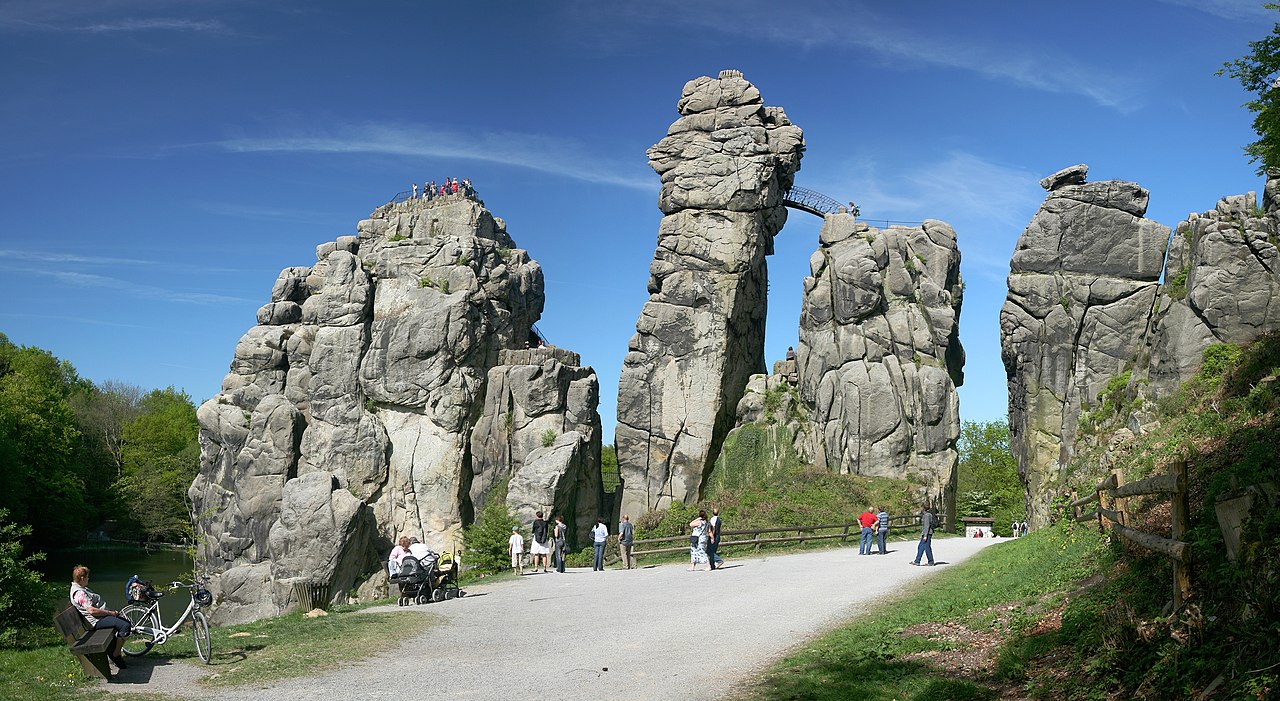
The Externsteine ([ˈɛkstɐnʃtaɪnə]) is a distinctive sandstone rock formation located in the Teutoburg Forest, near the town of Horn-Bad Meinberg in the Lippe district of the German state of North Rhine-Westphalia. The formation is a tor consisting of several tall, narrow columns of rock which rise abruptly from the surrounding wooded hills. In a popular tradition going back to an idea proposed to Hermann Hamelmann in 1564, the Externsteine are identified as a sacred site of the pagan Saxons, and the location of the Irminsul idol reportedly destroyed by Charlemagne; there is however no archaeological evidence that would confirm the site's use during the relevant period. The stones were used as the site of a hermitage in the Middle Ages, and by at least the high medieval period were the site of a Christian chapel. The Externsteine relief is a medieval depiction of the Descent from the Cross. It remains controversial whether the site was already used for Christian worship in the 8th to early 10th centuries. (Source: Wikipedia.org, CC BY-SA)
Eyjafjallajökull (Icelandic: [ˈeiːjaˌfjatlaˌjœːkʏtl̥] ; lit. 'glacier of the mountains of the islands'), sometimes referred to by the numeronym E15, is one of the smaller ice caps of Iceland, north of Skógar and west of Mýrdalsjökull. The ice cap covers the caldera of a volcano with a summit elevation of 1,651 metres (5,417 ft). The volcano has erupted relatively frequently since the Last Glacial Period, most recently in 2010, when, although relatively small for a volcanic eruption, it caused enormous disruption to air travel across northern and western Europe for a week. (Source: Wikipedia.org, CC BY-SA)
The Franz Josef Glacier (Māori: Kā Roimata o Hine Hukatere; officially Franz Josef Glacier / Kā Roimata o Hine Hukatere) is a 12-kilometre-long (7.5 mi) temperate maritime glacier in Westland Tai Poutini National Park on the West Coast of New Zealand's South Island. Together with the Fox Glacier 20 kilometres (12 mi) to the south, and a third glacier, it descends from the Southern Alps to less than 300 metres (980 ft) above sea level. The area surrounding the two glaciers is part of Te Wahipounamu, a World Heritage Site park. The Waiho River emerges from the glacier terminal of Franz Josef. (Source: Wikipedia.org, CC BY-SA)
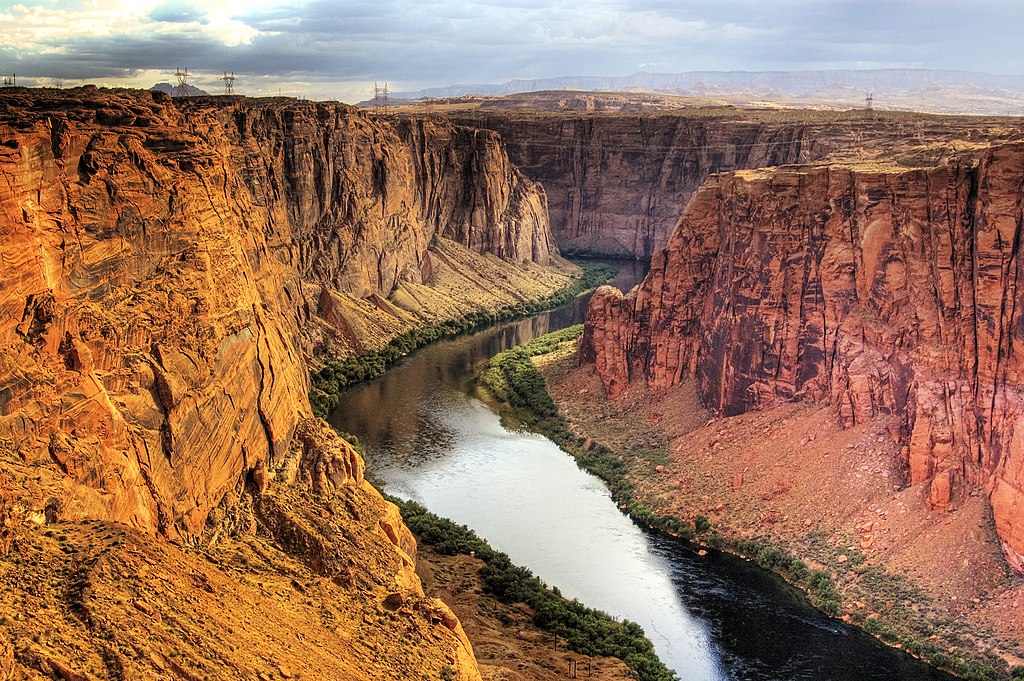
Glen Canyon is a natural canyon carved by a 169.6-mile (272.9 km) length of the Colorado River, mostly in southeastern and south-central Utah, in the United States. Glen Canyon starts where Narrow Canyon ends, at the confluence of the Colorado River and the Dirty Devil River. A small part of the lower end of Glen Canyon extends into northern Arizona and terminates at Lee's Ferry, near the Vermilion Cliffs. Like the Grand Canyon farther downstream, Glen Canyon is part of the immense system of canyons carved by the Colorado River and its tributaries. (Source: Wikipedia.org, CC BY-SA)
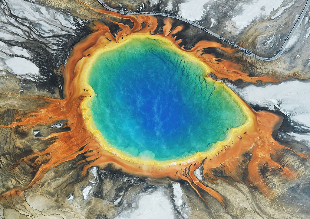
The Grand Prismatic Spring in Yellowstone National Park is the largest hot spring in the United States, and the third largest in the world, after Frying Pan Lake in New Zealand and Boiling Lake in Dominica. It is located in the Midway Geyser Basin. Grand Prismatic Spring was noted by geologists working in the Hayden Geological Survey of 1871, and named by them for its striking coloration. Its colors match most of those seen in the rainbow dispersion of white light by an optical prism: red, orange, yellow, green, and blue. (Source: Wikipedia.org, CC BY-SA)
The Grose Valley is a rugged valley in the Blue Mountains, New South Wales, Australia. It has been formed by the Grose River, the headwaters of which are in the Mount Victoria area. The valley is located between the Great Western Highway and Bells Line of Road, the two major routes across the Blue Mountains. The majority of the valley falls within the Blue Mountains National Park. The Grose Wilderness contains some of the most dramatic gorge and canyon landscapes of the entire Sydney basin sandstone region. The Grose also constitutes one of the most accessible wilderness areas for bushwalking or public observation from its escarpment margins. (Source: Wikipedia.org, CC BY-SA)
Grímsvötn (Icelandic pronunciation: [ˈkrimsˌvœhtn̥]; vötn = 'waters', singular: vatn) is a volcano with a (partially subglacial) fissure system located in Vatnajökull National Park, Iceland. The volcano itself is completely subglacial and located under the northwestern side of the Vatnajökull ice cap. The subglacial caldera is at 64°25′N 17°20′W, at an elevation of 1,725 m (5,659 ft). Beneath the caldera is the magma chamber of the Grímsvötn volcano. Grímsvötn is a basaltic volcano which has the highest eruption frequency of all the volcanoes in Iceland and has a southwest-northeast-trending fissure system. The massive climate-impacting Laki fissure eruption of 1783–1784 was a part of the same fissure system. Grímsvötn was erupting at the same time as Laki during 1783, but continued to erupt until 1785. Because most of the volcanic system lies underneath Vatnajökull, most of its eruptions have been subglacial and the interaction of magma and meltwater from the ice causes phreatomagmatic explosive activity. (Source: Wikipedia.org, CC BY-SA)
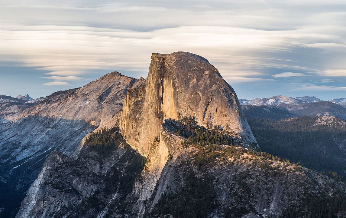
Half Dome is a quartz monzonite batholith at the eastern end of Yosemite Valley in Yosemite National Park, California. It is a well-known rock formation in the park, named for its distinct shape. One side is a sheer face while the other three sides are smooth and round, making it appear like a dome cut in half. It stands at nearly 8,800 feet above sea level and is composed of quartz monzonite, an igneous rock that solidified several thousand feet within the Earth. At its core are the remains of a magma chamber that cooled slowly and crystallized beneath the Earth's surface. The solidified magma chamber was then exposed and cut in half by erosion, therefore leading to the geographic name Half Dome. (Source: Wikipedia.org, CC BY-SA)
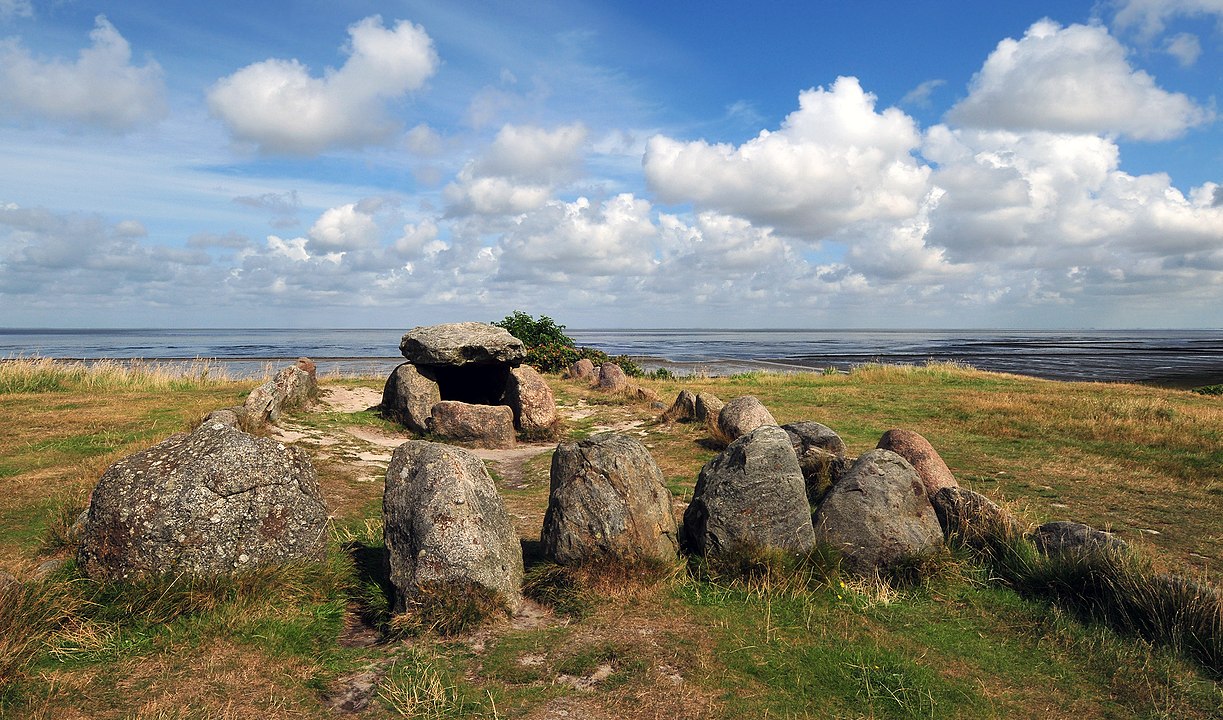
The Harhoog is a dolmen, a rectangular megalithic tomb from the Funnelbeaker culture, located near Keitum on the island of Sylt in Schleswig-Holstein, Germany. Discovered in 1925, it was moved to the present site in 1954 when a new airport was developed. The megalithic Harhoog burial chambers were originally located near the mud-flats between Keitum and Tinnum. The stones were moved to the area near the Tipkenhoog on the coast near Keitum in 1954, when Sylt Airport was under development.: 147 The chambers contain parallel and transverse sections. (Source: Wikipedia.org, CC BY-SA)
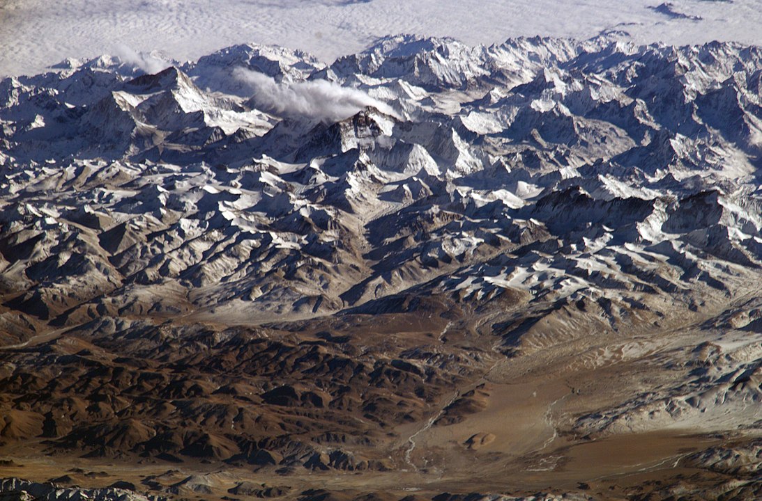
The Himalayas, or Himalaya (/ˌhɪməˈleɪ.ə, hɪˈmɑːləjə/; Sanskrit: [ɦɪmaːlɐjɐ]; from Sanskrit himá 'snow, frost', and ā-laya 'dwelling, abode'), is a mountain range in Asia, separating the plains of the Indian subcontinent from the Tibetan Plateau. The range has some of the Earth's highest peaks, including the very highest, Mount Everest. Over 100 peaks exceeding 7,200 m (23,600 ft) in elevation lie in the Himalayas. The Himalayas abut or cross five countries: Bhutan, India, Nepal, China, and Pakistan. The sovereignty of the range in the Kashmir region is disputed among India, Pakistan, and China. The Himalayan range is bordered on the northwest by the Karakoram and Hindu Kush ranges, on the north by the Tibetan Plateau, and on the south by the Indo-Gangetic Plain. Some of the world's major rivers, the Indus, the Ganges, and the Tsangpo–Brahmaputra, rise in the vicinity of the Himalayas, and their combined drainage basin is home to some 600 million people; 53 million people live in the Himalayas. (Source: Wikipedia.org, CC BY-SA)
 © Wikimedia.org/NASA, CC0

Time for recess! Post a comment, ask a question or write a review. Feel free to let us know what you think!
look at the sign on the road to avoid accidents and horrible driving conditions
 -3
-3
I received a 300$ ticket because I passed a police control of other cars/drivers on the right lane of a highway (the control was on the hard shoulder of the highway). Is it really true, that you have to change the lane in such cases? Thanks!
I am an American living in Italy. The Italian Drivers License theory test is the hardest test I have ever studied for and I am in my 70s have multiple degrees, multiple professional certifications. Have to take the Italian Drivers Theory test in Italian. No english. So many rules. More signs in small medieval Italian town I live in then in major US cities I have lived in. No Italian license no driving. No buying or renting a car. Test here was good, clean. Lots of tricky questions on many practice and real official tests. Thanks
Most problems are a result of higher than safe driving speeds. Please just slow down and be patient.
Question 121: Poor translation: Vehicles with polluted fluids prohibited Should be translated as: Vehicles with dangerous liquids prohibited
Question 83: Poor translation: Vehicles with polluted fluids prohibited Should be translated as: Vehicles with dangerous liquids prohibited
0
Want even more practice? Visit similar websites offering realistic practice driving knowledge tests. Visit us to see what sets our tests apart! https://dkttest.com/capital-territory/
Cool tool! And fun to check whether I remember the rules :) Two things I noticed: Warning for a crossroad side roads on the left and right. While technically that might be the correct translation, this sign tells you, that you are on the main road and have the right of way for the next crossroad and only the next crossroad. Usually (if no sign specifies otherwise) you have to give way to drivers coming from the right at every intersection, which can get a bit annoying in communal areas, so seeing this sign feels less like a warning and more like relief :). A Fahrradstraße is not a lane for cyclists but a street for cyclists, meaning the (whole!) street is intended predominantly for cyclists, who are then allowed to ride next to each other. Cars are allowed to drive there (unless another sign prohibits such), but have to adjust their speed to the cyclists. I believe they are not allowed to pass at all, even if the oncoming lane is empty.


More community