

Here you can study for the exam. Look up keywords and learn definitions about all kind of subjects.
More subjects
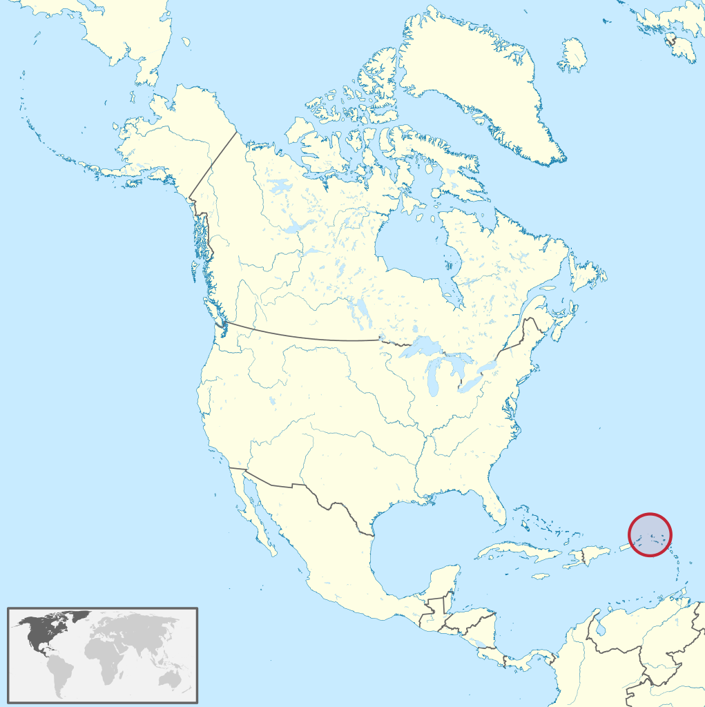
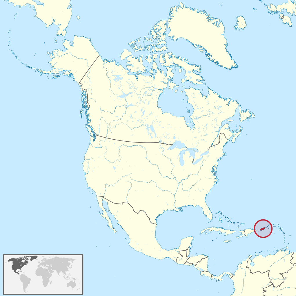
Anguilla (/æŋˈɡwɪlə/ ang-GWIL-ə) is a British Overseas Territory in the Caribbean. It is one of the most northerly of the Leeward Islands in the Lesser Antilles, lying east of Puerto Rico and the Virgin Islands and directly north of Saint Martin. The territory consists of the main island of Anguilla, approximately 16 miles (26 kilometres) long by 3 miles (5 km) wide at its widest point, together with a number of much smaller islands and cays with no permanent population. The territory's capital is The Valley. The total land area of the territory is 35 square miles (91 km2), with a population of approximately 15,753 (2021). (Source: Wikipedia.org, CC BY-SA)
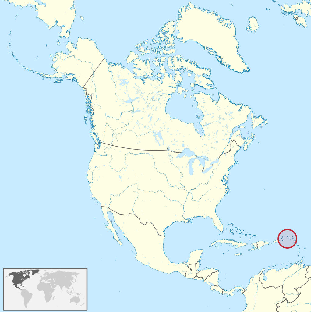
Antigua and Barbuda (UK: /ænˈtiːɡə ... bɑːrˈbuːdə/, US: /ænˈtiːɡwə ... bɑːrˈbjuːdə/) is a sovereign country in the West Indies. It lies at the juncture of the Caribbean Sea and the Atlantic Ocean in the Leeward Islands part of the Lesser Antilles, at 17°N latitude. The country consists of two major islands, Antigua and Barbuda, approximately 40 km (20 mi) apart, and several smaller islands, including Great Bird, Green, Guiana, Long, Maiden, Prickly Pear, York, and Redonda. The permanent population is approximately 97,120 (2019 est.), 97% residing in Antigua. St. John's, Antigua, is the country's capital, major city, and largest port. Codrington is Barbuda's largest town. The economy of Antigua and Barbuda is largely dependent on tourism, which accounts for 80% of GDP. Like other island nations, Antigua and Barbuda is vulnerable to the effects of climate change, such as sea level rise, and increased intensity of extreme weather like hurricanes. These cause coastal erosion, water scarcity, and other challenges. Antigua and Barbuda has the world's 25th most powerful passport as of 2022 and offers a citizenship by investment program. The country levies no personal income tax. (Source: Wikipedia.org, CC BY-SA)
Aruba (/əˈruːbə/ ə-ROO-bə, Dutch: [aːˈrubaː, -ryb-] , Papiamento: [aˈruba]), officially the Country of Aruba (Dutch: Land Aruba; Papiamento: Pais Aruba) is a constituent country of the Kingdom of the Netherlands physically located in the mid-south of the Caribbean Sea, about 29 kilometres (18 mi) north of the Venezuelan peninsula of Paraguaná and 80 kilometres (50 mi) northwest of Curaçao. It measures 32 kilometres (20 mi) long from its northwestern to its southeastern end and 10 kilometres (6 mi) across at its widest point. Together with Bonaire and Curaçao, Aruba forms a group referred to as the ABC islands. Collectively, these and the other three Dutch substantial islands in the Caribbean are often called the Dutch Caribbean, of which Aruba has about one-third of the population. In 1986, it became a constituent country within the Kingdom of the Netherlands, and acquired the formal name the Country of Aruba. Aruba is one of the four countries that form the Kingdom of the Netherlands, along with the Netherlands, Curaçao, and Sint Maarten; the citizens of these countries are all Dutch nationals. Aruba has no administrative subdivisions, but, for census purposes, is divided into eight regions. Its capital is Oranjestad. (Source: Wikipedia.org, CC BY-SA)
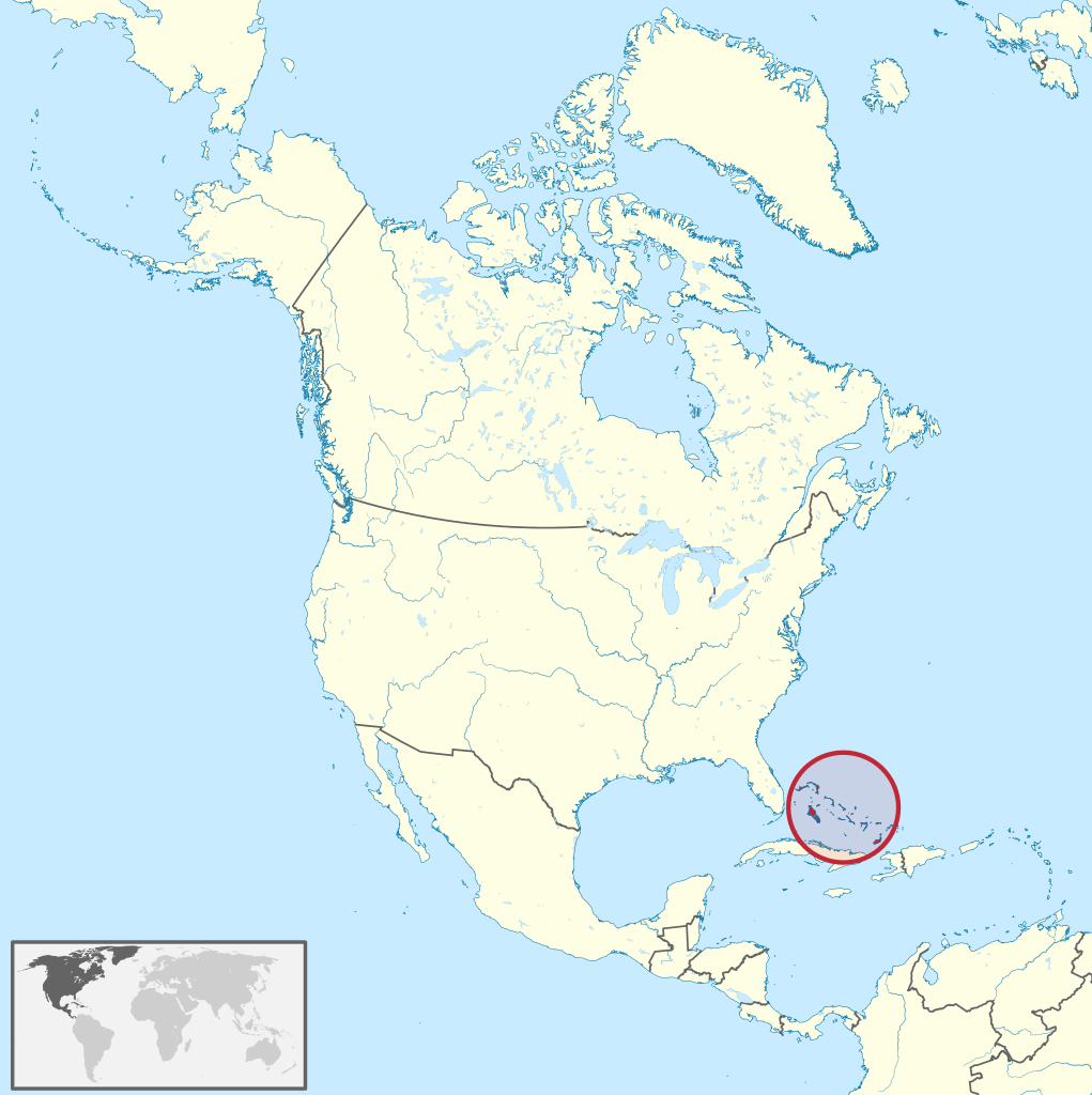
The Bahamas (/bəˈhɑːməz/ ), officially the Commonwealth of The Bahamas, is a country within the Lucayan Archipelago of the West Indies in the Atlantic. It takes up 97% of the Lucayan Archipelago's land area and is home to 88% of the archipelago's population. The archipelagic state consists of more than 3,000 islands, cays, and islets in the Atlantic Ocean, and is located north of Cuba and northwest of the island of Hispaniola (split between Haiti and the Dominican Republic) and the Turks and Caicos Islands, southeast of the US state of Florida, and east of the Florida Keys. The capital is Nassau on the island of New Providence. The Royal Bahamas Defence Force describes The Bahamas' territory as encompassing 470,000 km2 (180,000 sq mi) of ocean space. The Bahamas became a British crown colony in 1718, when the British clamped down on piracy. After the American Revolutionary War, the Crown resettled thousands of American Loyalists to the Bahamas; they took enslaved people with them and established plantations on land grants. Enslaved African people and their descendants constituted the majority of the population from this period on. The slave trade was abolished by the British in 1807; slavery in the Bahamas was abolished in 1834. Subsequently, the Bahamas became a haven for freed African slaves. Africans liberated from illegal slave ships were resettled on the islands by the Royal Navy, while some North American slaves and Seminoles escaped to the Bahamas from Florida. Bahamians were even known to recognise the freedom of enslaved people carried by the ships of other nations which reached the Bahamas. Today Black-Bahamians make up 90% of the population of 400,516. (Source: Wikipedia.org, CC BY-SA)
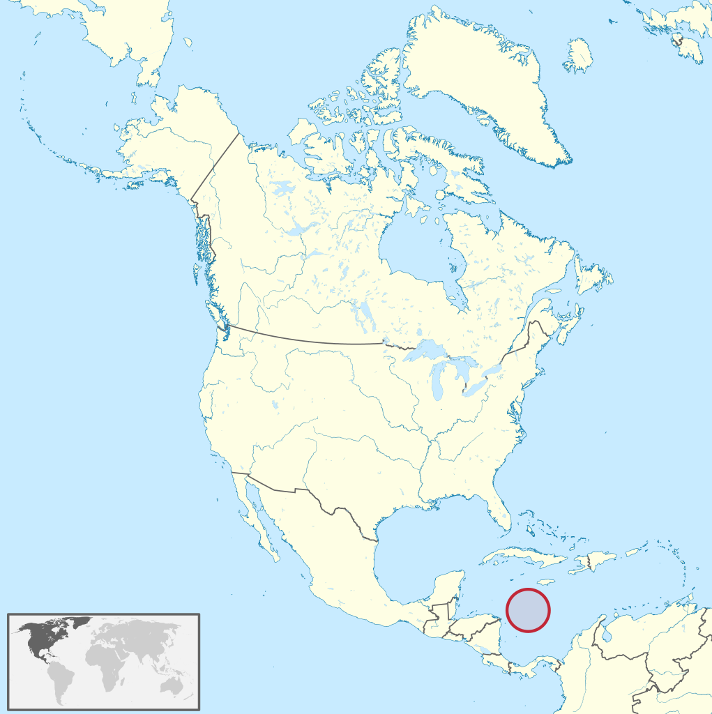
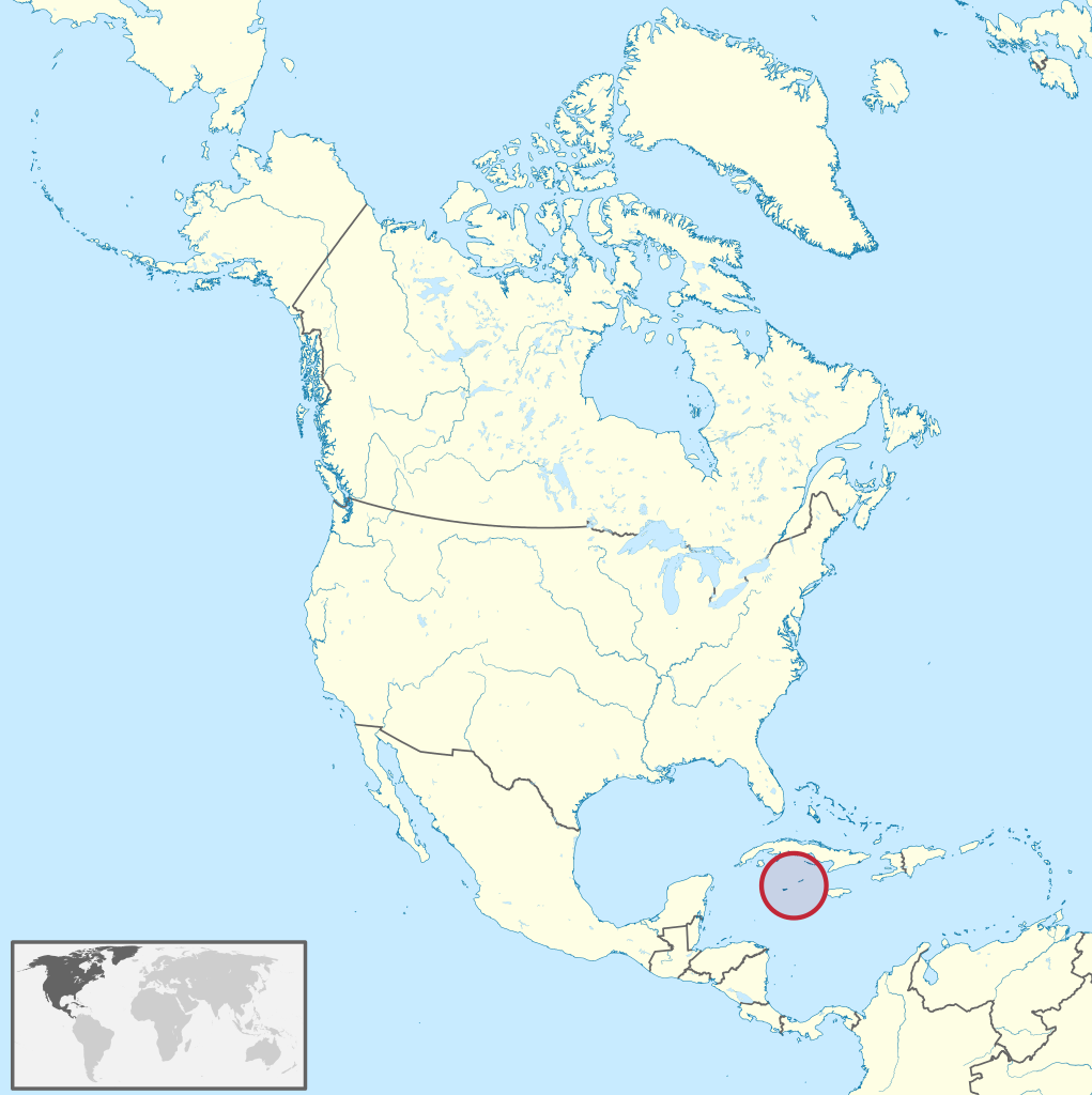
Bajo Nuevo Bank, also known as the Petrel Islands (Spanish: Bajo Nuevo, Islas Petrel), is a small, uninhabited reef with some small grass-covered islets, located in the western Caribbean Sea at WikiMiniAtlas15°53′N 78°38′WCoordinates: 15°53′N 78°38′W, with a lighthouse on Low Cay at 15°51′N 78°38′W. The closest neighbouring land feature is Serranilla Bank, located 110 kilometres (68 miles) to the west. The reef was first shown on Dutch maps dating to 1634 but was given its present name in 1654. Bajo Nuevo was rediscovered by the English pirate John Glover in 1660. The reef is now subject to a sovereignty dispute involving Colombia and the United States. On 19 November 2012, in regards to Nicaraguan claims to the islands, the International Court of Justice (ICJ) found, unanimously, that the Republic of Colombia has sovereignty over both Bajo Nuevo and Serranilla Banks. Bajo Nuevo Bank is about 26 km (16 mi) long and 9 km (5.6 mi) wide. The satellite image shows two distinct atoll-like structures separated by a deep channel 1.4 km (0.87 mi) wide at its narrowest point. The larger southwestern reef complex measures 15.4 km (9.6 mi) northeast-southwest, and is up to 9.4 km (5.8 mi) wide, covering an area of about 100 km2 (39 sq mi). The reef partially dries on the southern and eastern sides. The smaller northeastern reef complex measures 10.5 km (6.5 mi) east-west and is up to 5.5 km (3.4 mi) wide, covering an area of 45 km2 (17 sq mi). The land area is minuscule by comparison. (Source: Wikipedia.org, CC BY-SA)
Barbados is an island country in the Lesser Antilles of the West Indies, in the Caribbean region of the Americas, and the most easterly of the Caribbean Islands. It occupies an area of 432 km2 (167 sq mi) and has a population of about 287,000 (2019 estimate). Its capital and largest city is Bridgetown. Inhabited by Kalinago people since the 13th century, and prior to that by other Amerindians, Spanish navigators took possession of Barbados in the late 15th century, claiming it for the Crown of Castile. It first appeared on a Spanish map in 1511. The Portuguese Empire claimed the island between 1532 and 1536, but abandoned it in 1620 with their only remnants being an introduction of wild boars for a good supply of meat whenever the island was visited. An English ship, the Olive Blossom, arrived in Barbados on 14 May 1625; its men took possession of the island in the name of King James I. In 1627, the first permanent settlers arrived from England, and Barbados became an English and later British colony. During this period, the colony operated on a plantation economy, relying on the labour of enslaved Africans who worked on the island's plantations. The slave trade to the island continued until it was outlawed throughout the British Empire by the Slave Trade Act 1807, with final emancipation of enslaved persons in Barbados occurring over a period of five years following the Slavery Abolition Act 1833. (Source: Wikipedia.org, CC BY-SA)
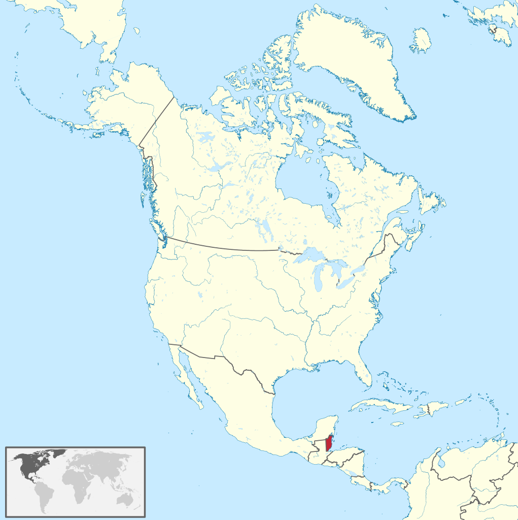
Belize (/bəˈliːz/ ) is a Caribbean country on the northeastern coast of Central America. It is bordered by Mexico to the north, the Caribbean Sea to the east, and Guatemala to the west and south. It has an area of 22,970 square kilometres (8,867 sq mi) and a population of 397,621 (2020). Its mainland is about 290 km (180 mi) long and 110 km (68 mi) wide. It is the least populated and least densely populated country in Central America. Its population growth rate of 1.87% per year (2018 estimate) is the second-highest in the region and one of the highest in the Western Hemisphere. Its capital is Belmopan, and its largest city is the namesake city of Belize City. Belize is often thought of as a Caribbean country in Central America because it has a history similar to that of English-speaking Caribbean nations. Indeed, Belize’s institutions and official language reflect its history as a British colony. (Source: Wikipedia.org, CC BY-SA)
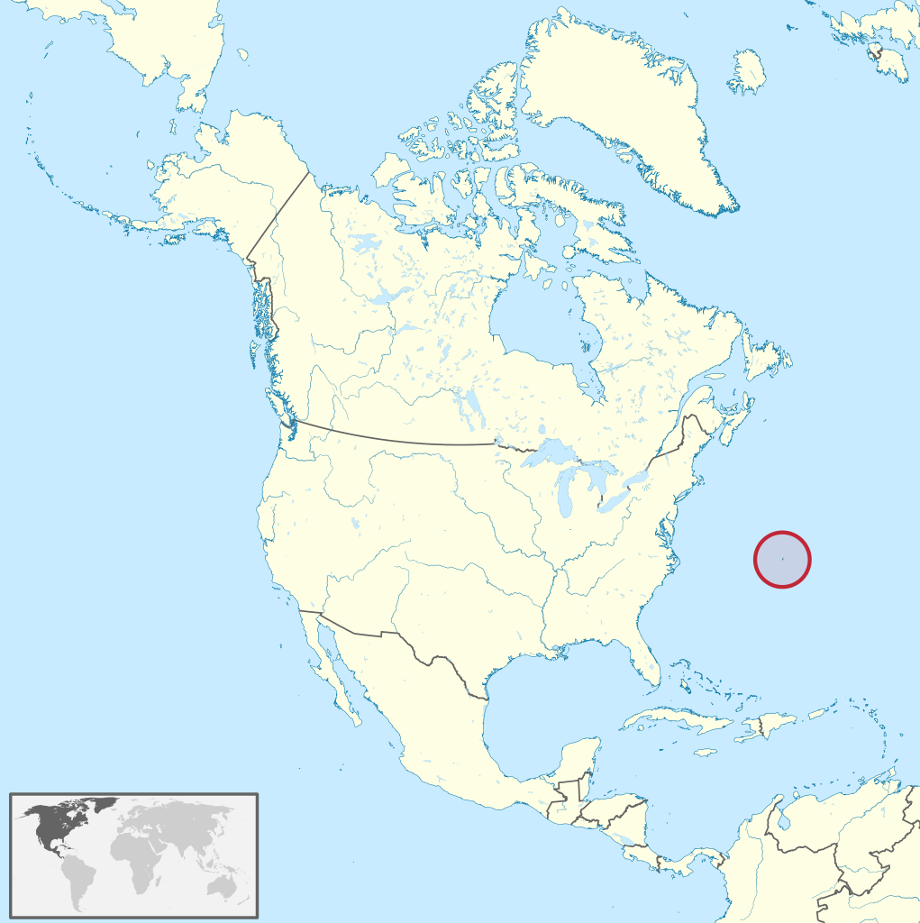
Bermuda (/bərˈmjuːdə/; historically known as the Bermudas or Somers Isles) is a British Overseas Territory in the North Atlantic Ocean. The Bermuda archipelago consists of 181 islands with a total land area of 54 km2 (21 sq mi). The closest land outside the territory is in the US state of North Carolina, approximately 1,035 km (643 mi) to the west-northwest. Bermuda is named after Spanish explorer Juan de Bermúdez, who discovered the archipelago in 1505. The islands have been permanently inhabited since 1612, and, forming part of British America, became a crown colony in 1684. The first African slaves arrived in 1616, but as the slave trade ceased by the end of the 17th century, the colony developed into a base for merchants, privateers, and the Royal Navy. More recently, tourism has been a significant contributor to Bermuda's economy. After World War II the territory became a prominent offshore financial centre and tax haven. As of July 2018, Bermuda had a population of around 70,000 people, making it the most populous of the British overseas territories. Black Bermudians, primarily descended from African slaves, make up around 50% of the population, while White Bermudians, primarily of British, Irish and Portuguese descent, account for 30%. (Source: Wikipedia.org, CC BY-SA)
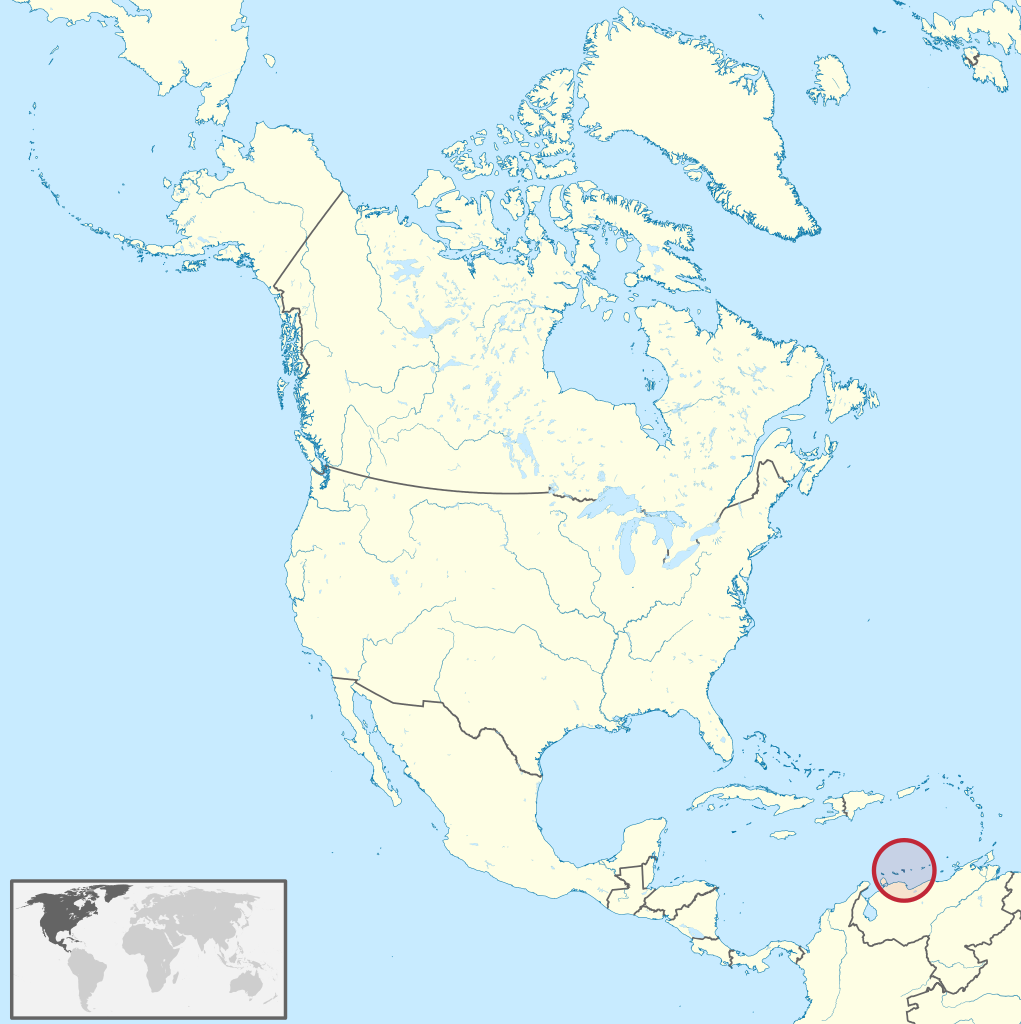
Bonaire (/bɒnˈɛər/; Dutch: Bonaire, pronounced [boːˈnɛːr(ə)] ; Papiamento: Boneiru, [buˈneiru], almost pronounced [boˈnɛiru]) is a Dutch island in the Leeward Antilles in the Caribbean Sea. Its capital is the port of Kralendijk, on the west (leeward) coast of the island. Aruba, Bonaire and Curaçao form the ABC islands, 80 km (50 miles) off the coast of Venezuela. Unlike much of the Caribbean region, the ABC islands lie outside Hurricane Alley. The islands have an arid climate that attracts visitors seeking warm, sunny weather all year round. Bonaire is a popular snorkeling and scuba diving destination because of its multiple shore diving sites and easy access to the island's fringing reefs. Bonaire was part of the Netherlands Antilles until the country's dissolution in 2010, when the island became a special municipality (officially, a 'Caribbean public body') within the country of the Netherlands. It is one of three special municipalities in the Caribbean; the others are Sint Eustatius and Saba. 80% of Bonaire's population are Dutch nationals, and nearly 60% of its residents were born in the former Netherlands Antilles and Aruba. (Source: Wikipedia.org, CC BY-SA)
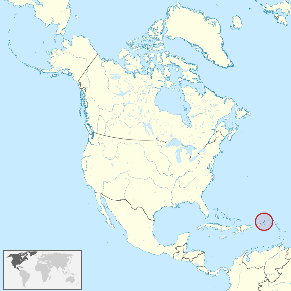
The British Virgin Islands (BVI), officially the Virgin Islands, are a British Overseas Territory in the Caribbean, to the east of Puerto Rico and the US Virgin Islands and north-west of Anguilla. The islands are geographically part of the Virgin Islands archipelago and are located in the Leeward Islands of the Lesser Antilles and part of the West Indies. The British Virgin Islands consist of the main islands of Tortola, Virgin Gorda, Anegada and Jost Van Dyke, along with more than 50 other smaller islands and cays. About 16 of the islands are inhabited. The capital, Road Town, is on Tortola, the largest island, which is about 20 km (12 mi) long and 5 km (3 mi) wide. The islands had a population of 28,054 at the 2010 Census, of whom 23,491 lived on Tortola; current estimates put the population at 35,802 (July 2018). British Virgin Islanders are British Overseas Territories citizens and since 2002, are also British citizens. (Source: Wikipedia.org, CC BY-SA)
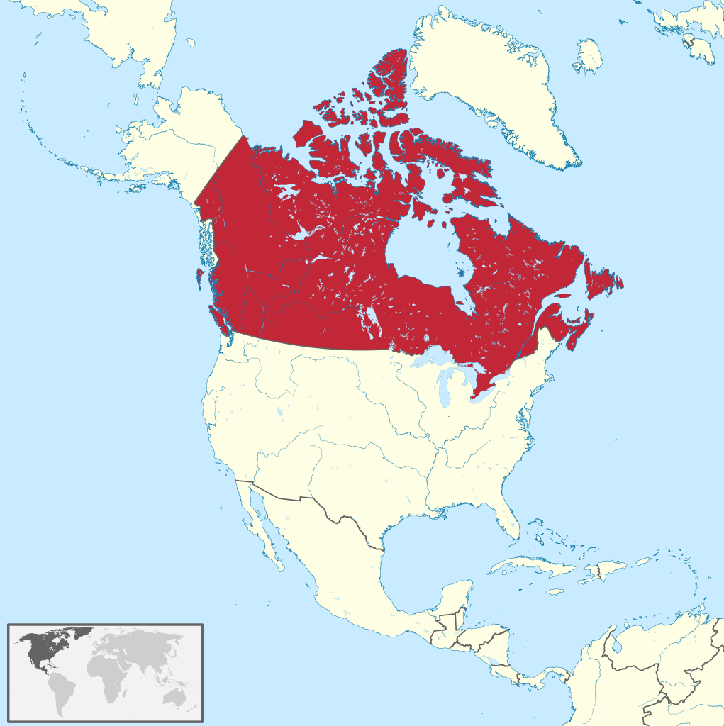
Canada is a country in North America. Its ten provinces and three territories extend from the Atlantic Ocean to the Pacific Ocean and northward into the Arctic Ocean, covering over 9.98 million square kilometres (3.85 million square miles), making it the world's second-largest country by total area. Its southern and western border with the United States, stretching 8,891 kilometres (5,525 mi), is the world's longest binational land border. Canada's capital is Ottawa, and its three largest metropolitan areas are Toronto, Montreal, and Vancouver. Indigenous peoples have continuously inhabited what is now Canada for thousands of years. Beginning in the 16th century, British and French expeditions explored and later settled along the Atlantic coast. As a consequence of various armed conflicts, France ceded nearly all of its colonies in North America in 1763. In 1867, with the union of three British North American colonies through Confederation, Canada was formed as a federal dominion of four provinces. This began an accretion of provinces and territories and a process of increasing autonomy from the United Kingdom. This widening autonomy was highlighted by the Statute of Westminster 1931 and culminated in the Canada Act 1982, which severed the vestiges of legal dependence on the Parliament of the United Kingdom. (Source: Wikipedia.org, CC BY-SA)
The Cayman Islands (/ˈkeɪmən/) is a self-governing British Overseas Territory—the largest by population in the western Caribbean Sea. The 264-square-kilometre (102-square-mile) territory comprises the three islands of Grand Cayman, Cayman Brac and Little Cayman, which are located to the south of Cuba and northeast of Honduras, between Jamaica and Mexico's Yucatán Peninsula. The capital city is George Town on Grand Cayman, which is the most populous of the three islands. The Cayman Islands is considered to be part of the geographic Western Caribbean Zone as well as the Greater Antilles. The territory is a major world offshore financial centre for international businesses and wealthy individuals, largely as a result of the state not charging taxes on any income earned or stored. With a GDP per capita of $91,392, the Cayman Islands has the highest standard of living in the Caribbean. Immigrants from over 130 countries and territories reside in the Cayman Islands. (Source: Wikipedia.org, CC BY-SA)
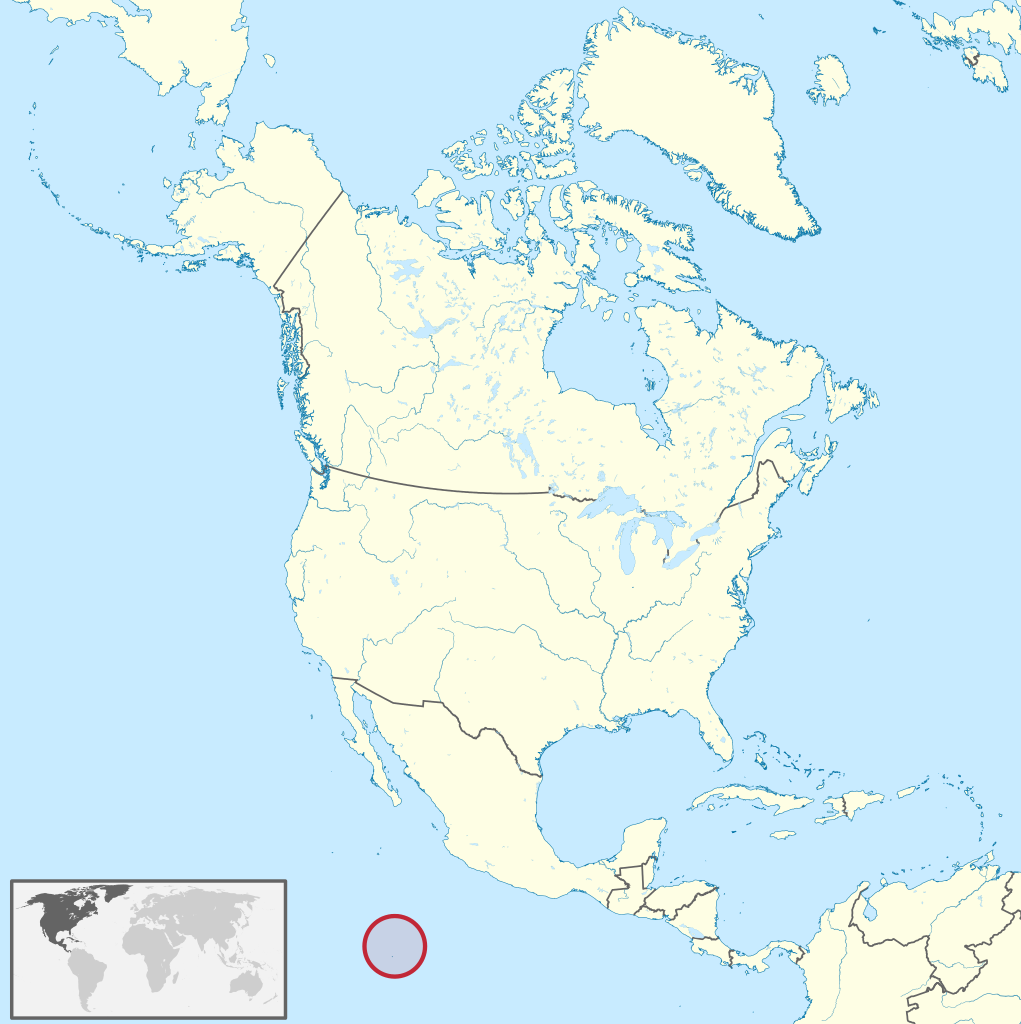
Clipperton Island (French: Île de Clipperton or Île de la Passion; Spanish: Isla de la Pasión) is an uninhabited, 6 km2 (2.3 sq mi) coral atoll in the eastern Pacific Ocean. It is 10,677 km (6,634 mi) from Paris, France, 5,400 km (2,900 nmi) from Papeete, Tahiti, and 1,080 km (580 nmi) from Mexico. It is an overseas state private property of France under direct authority of the Minister of the Overseas. In the past, Clipperton Island was the subject of a sovereignty dispute in particular between France and Mexico, which was finally settled through arbitration in 1931; the Clipperton Island Case remains widely studied in international law textbooks. The atoll is 1,080 km (583 nmi) south-west of Mexico, 2,424 km (1,309 nmi) west of Nicaragua, 2,545 km (1,374 nmi) west of Costa Rica and 2,260 km (1,220 nmi) north-west of the Galápagos Islands, Ecuador, at 10°18′N 109°13′W. Clipperton is about 945 km (510 nmi) south-east of Socorro Island in the Revillagigedo Archipelago, which is the nearest land, while the nearest French-owned island is Hiva Oa. Some consider it to be one of the eastern-most points of Oceania, rather than an outlying island of the Americas. (Source: Wikipedia.org, CC BY-SA)
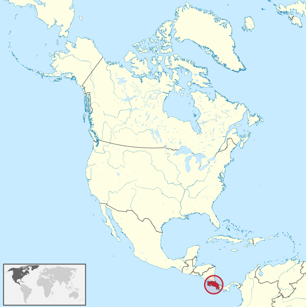
Costa Rica (UK: /ˌkɒstə ˈriːkə/, US: /ˌkoʊstə/ ; Spanish: [ˈkosta ˈrika]; literally 'Rich Coast'), officially the Republic of Costa Rica (Spanish: República de Costa Rica), is a country in Central America, bordered by Nicaragua to the north, the Caribbean Sea to the northeast, Panama to the southeast, the Pacific Ocean to the southwest, and maritime border with Ecuador to the south of Cocos Island. It has a population of around five million in a land area of 51,060 km2 (19,710 sq mi). An estimated 333,980 people live in the capital and largest city, San José, with around two million people in the surrounding metropolitan area. Costa Rica was inhabited by indigenous peoples before coming under Spanish rule in the 16th century. It remained a peripheral colony of the empire until independence as part of the First Mexican Empire, followed by membership in the Federal Republic of Central America, from which it formally declared independence in 1847. Following the brief Costa Rican Civil War in 1948, it permanently abolished its army in 1949, becoming one of only a few sovereign nations without a standing army. (Source: Wikipedia.org, CC BY-SA)
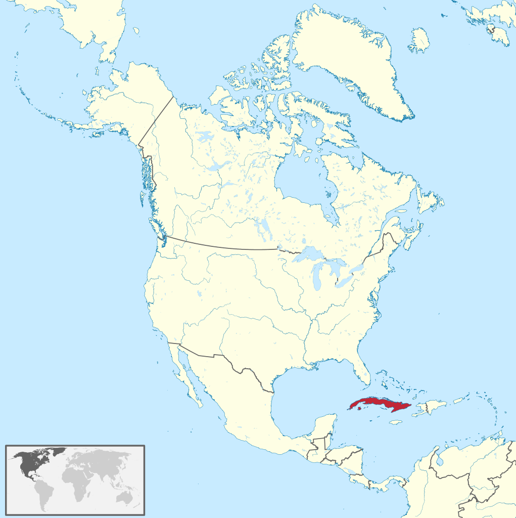
Cuba (/ˈkjuːbə/ KEW-bə, Spanish: [ˈkuβa] ), officially the Republic of Cuba (Spanish: República de Cuba [reˈpuβlika ðe ˈkuβa] ), is an island country comprising the island of Cuba, as well as Isla de la Juventud and several minor archipelagos. Cuba is located where the northern Caribbean Sea, Gulf of Mexico, and Atlantic Ocean meet. Cuba is located east of the Yucatán Peninsula (Mexico), south of both the American state of Florida and the Bahamas, west of Hispaniola (Haiti/Dominican Republic), and north of both Jamaica and the Cayman Islands. Havana is the largest city and capital; other major cities include Santiago de Cuba and Camagüey. The official area of the Republic of Cuba is 109,884 km2 (42,426 sq mi) (without the territorial waters) but a total of 350,730 km² (135,418 sq mi) including the exclusive economic zone. Cuba is the second-most populous country in the Caribbean after Haiti, with over 11 million inhabitants. (Source: Wikipedia.org, CC BY-SA)
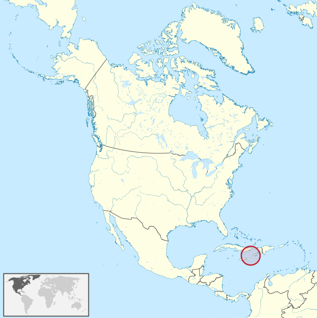
Curaçao (/ˈkjʊərəsoʊ, -saʊ, ˌkjʊərəˈsoʊ, -ˈsaʊ/ KYURE-əss-oh, -ow, -OH, -OW; Dutch: [kyːraːˈsʌu, kuːr-] ; Papiamento: Kòrsou, [ˈkɔrsɔu̯]), officially the Country of Curaçao (Dutch: Land Curaçao; Papiamento: Pais Kòrsou), is a Lesser Antilles island country in the southern Caribbean Sea and the Dutch Caribbean region, about 65 km (40 mi) north of the Venezuelan coast. It is a colony of the Kingdom of the Netherlands. Together with Aruba and Bonaire, it forms the ABC islands. Collectively, Curaçao, Aruba, and other Dutch islands in the Caribbean are often called the Dutch Caribbean. Curaçao was formerly part of the Curaçao and Dependencies colony from 1815 to 1954 and later the Netherlands Antilles from 1954 to 2010, as Island Territory of Curaçao (Dutch: Eilandgebied Curaçao, Papiamento: Teritorio Insular di Kòrsou), and is now formally called the Country of Curaçao. It includes the main island of Curaçao and the much smaller, uninhabited island of Klein Curaçao ('Little Curaçao'). Curaçao has a population of 158,665 (January 2019 est.), with an area of 444 km2 (171 sq mi); its capital is Willemstad. (Source: Wikipedia.org, CC BY-SA)
Dominica (/ˌdɒmɪˈniːkə/ or /dəˈmɪnɪkə/ ; Kalinago: Wai‘tu kubuli; French: Dominique; Dominican Creole French: Dominik), officially the Commonwealth of Dominica, is an island country in the Caribbean. The capital, Roseau, is located on the western side of the island. It is geographically situated as part of the Windward Islands chain in the Lesser Antilles archipelago in the Caribbean Sea. Dominica's closest neighbours are two constituent territories of the European Union, the overseas departments of France, Guadeloupe to the northwest and Martinique to the south-southeast. Dominica comprises a land area of 750 km2 (290 sq mi), and the highest point is Morne Diablotins, at 1,447 m (4,747 ft) in elevation. The population was 71,293 at the 2011 census. The island was settled by the Arawak arriving from South America in the fifth century. The Kalinago displaced the Arawak by the 15th century. Columbus is said to have passed the island on Sunday, 3 November 1493. It was later colonised by Europeans, predominantly by the French from the 1690s to 1763. The French imported enslaved people from West Africa to Dominica to work on coffee plantations. Great Britain took possession in 1763 after the Seven Years' War, and it gradually established English as its official language. The island gained independence as a republic in 1978. (Source: Wikipedia.org, CC BY-SA)
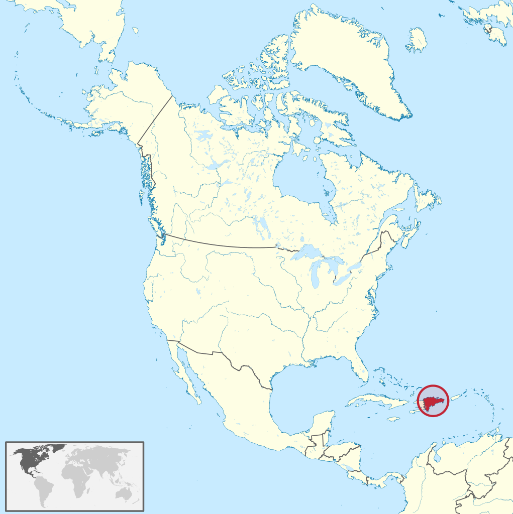
The Dominican Republic (/dəˈmɪnɪkən/ də-MIN-ik-ən; Spanish: República Dominicana, pronounced [reˈpuβlika ðominiˈkana] ) is a country located on the island of Hispaniola in the Greater Antilles archipelago of the Caribbean region. It occupies the eastern five-eighths of the island, which it shares with Haiti, making Hispaniola one of only two Caribbean islands, along with Saint Martin, that is shared by two sovereign states. The Dominican Republic is the second-largest nation in the Antilles by area (after Cuba) at 48,671 square kilometers (18,792 sq mi), and third-largest by population, with approximately 10.7 million people (2022 est.), down from 10.8 million in 2020, of whom approximately 3.3 million live in the metropolitan area of Santo Domingo, the capital city. The official language of the country is Spanish. The Dominican Republic is the most visited destination in the Caribbean. The year-round golf courses are major attractions. A geographically diverse nation, the Dominican Republic is home to both the Caribbean's tallest mountain peak, Pico Duarte, and the Caribbean's largest lake and lowest point, Lake Enriquillo. The island has an average temperature of 26 °C (78.8 °F) and great climatic and biological diversity. The country is also the site of the first cathedral, castle, monastery, and fortress built in the Americas, located in Santo Domingo's Colonial Zone, a World Heritage Site. Baseball is the de facto national sport. (Source: Wikipedia.org, CC BY-SA)
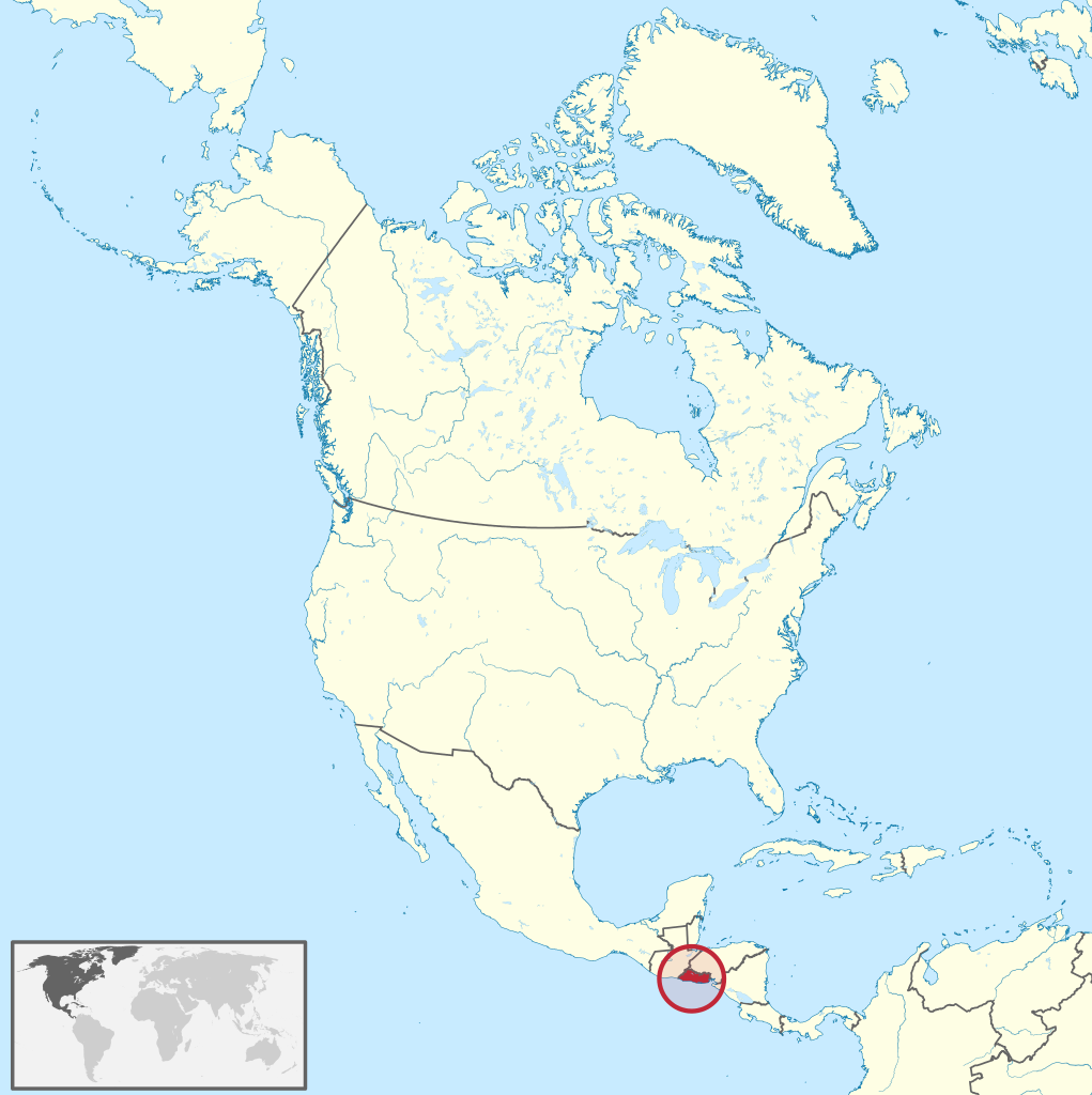
El Salvador (/ɛl ˈsælvədɔːr/ ; Spanish: [el salβaˈðoɾ] , meaning 'The Saviour'), officially the Republic of El Salvador (Spanish: República de El Salvador), is a country in Central America. It is bordered on the northeast by Honduras, on the northwest by Guatemala, and on the south by the Pacific Ocean. El Salvador's capital and largest city is San Salvador. The country's population in 2021 is estimated to be 6.8 million. Among the Mesoamerican nations that historically controlled the region are the Lenca (after 600 AD), the Mayans, and then the Cuzcatlecs. Archaeological monuments also suggest an early Olmec presence around the first millennium BC. In the beginning of the 16th century, the Spanish Empire conquered the Central American territory, incorporating it into the Viceroyalty of New Spain ruled from Mexico City. However the Viceroyalty of Mexico had little to no influence in the daily affairs of the isthmus, which was colonized in 1524. In 1609, the area was declared the Captaincy General of Guatemala by the Spanish, which included the territory that would become El Salvador until its independence from Spain in 1821. It was forcibly incorporated into the First Mexican Empire, then seceded, joining the Federal Republic of Central America in 1823. When the federation dissolved in 1841, El Salvador became a sovereign state, then formed a short-lived union with Honduras and Nicaragua called the Greater Republic of Central America, which lasted from 1895 to 1898. (Source: Wikipedia.org, CC BY-SA)
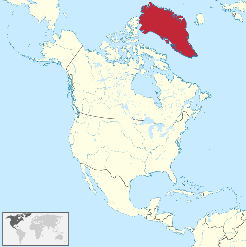
Greenland (Greenlandic: Kalaallit Nunaat, pronounced [kalaːɬit nʉnaːt]; Danish: Grønland, pronounced [ˈkʁɶnˌlænˀ]) is an island country in North America that is part of the Kingdom of Denmark. It is located between the Arctic and Atlantic oceans, east of the Canadian Arctic Archipelago. Greenland is the world's largest island. It is one of three constituent countries that form the Kingdom of Denmark, along with Denmark and the Faroe Islands; the citizens of these countries are all citizens of Denmark and the European Union. Greenland's capital is Nuuk. Though a part of the continent of North America, Greenland has been politically and culturally associated with Europe (specifically Norway and Denmark, the colonial powers) for more than a millennium, beginning in 986. Greenland has been inhabited at intervals over at least the last 4,500 years by Arctic peoples whose forebears migrated there from what is now Canada. Norsemen settled the uninhabited southern part of Greenland beginning in the 10th century, having previously settled Iceland. Inuit arrived in the 13th century. Though under continuous influence of Norway and Norwegians, Greenland was not formally under the Norwegian crown until 1261. The Norse colonies disappeared in the late 15th century after Norway was hit by the Black Death and entered a severe decline. (Source: Wikipedia.org, CC BY-SA)
Grenada (/ɡrəˈneɪdə/ grə-NAY-də; Grenadian Creole French: Gwenad /ɡwiˈnaɪd/) is an island country in the West Indies in the Caribbean Sea at the southern end of the Grenadines island chain. Grenada consists of the island of Grenada itself, two smaller islands, Carriacou and Petite Martinique, and several small islands which lie to the north of the main island and are a part of the Grenadines. It is located northwest of Trinidad and Tobago, northeast of Venezuela and southwest of Saint Vincent and the Grenadines. Its size is 348.5 square kilometres (134.6 sq mi), and it had an estimated population of 112,523 in July 2020. Its capital is St. George's. Grenada is also known as the 'Island of Spice' due to its production of nutmeg and mace crops. Coordinates: 12°07′N 61°40′WBefore the arrival of Europeans in the Americas, Grenada was inhabited by the indigenous peoples from South America. Christopher Columbus sighted Grenada in 1498 during his third voyage to the Americas. Following several unsuccessful attempts by Europeans to colonise the island due to resistance from resident Island Caribs, French settlement and colonisation began in 1649 and continued for the next century. On 10 February 1763, Grenada was ceded to the British under the Treaty of Paris. British rule continued until 1974 (except for a brief French takeover between 1779 and 1783). However, on 3 March 1967, it was granted full autonomy over its internal affairs as an Associated State, and from 1958 to 1962 Grenada was part of the Federation of the West Indies, a short-lived federation of British West Indian colonies. (Source: Wikipedia.org, CC BY-SA)
Guadeloupe (/ˌɡwɑːdəˈluːp/; French: [ɡwad(ə)lup] ; Antillean Creole: Gwadloup, [ɡwadlup]) is an archipelago and overseas department and region of France in the Caribbean. It consists of six inhabited islands—Basse-Terre, Grande-Terre, Marie-Galante, La Désirade, and the two inhabited Îles des Saintes—as well as many uninhabited islands and outcroppings. It is south of Antigua and Barbuda and Montserrat, north of the Commonwealth of Dominica. The region's capital city is Basse-Terre, located on the southern west coast of Basse-Terre Island; however, the most populous city is Les Abymes and the main centre of business is neighbouring Pointe-à-Pitre, both located on Grande-Terre Island. It had a population of 384,239 in 2019. Like the other overseas departments, it is an integral part of France. As a constituent territory of the European Union and the Eurozone, the euro is its official currency and any European Union citizen is free to settle and work there indefinitely. However, as an overseas department, it is not part of the Schengen Area. The region formerly included Saint Barthélemy and Saint Martin, which were detached from Guadeloupe in 2007 following a 2003 referendum. Christopher Columbus visited Guadeloupe in 1493, during his second voyage, and gave island its name. The official language is French; Antillean Creole is also spoken. (Source: Wikipedia.org, CC BY-SA)
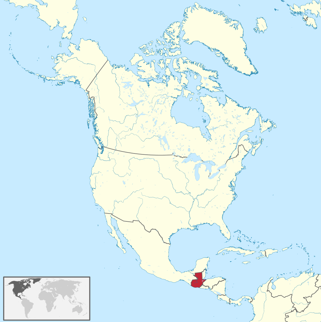
Guatemala (/ˌɡwɑːtəˈmɑːlə/ GWAH-tə-MAH-lə; Spanish: [ɡwateˈmala] ), officially the Republic of Guatemala (Spanish: República de Guatemala), is a country in Central America. Guatemala is bordered to the north and west by Mexico; to the northeast by Belize and the Caribbean; to the east by Honduras; to the southeast by El Salvador and to the south by the Pacific Ocean, respectively. With an estimated population of around 17.6 million, it is the most populous country in Central America and is the 11th most populous country in the Americas. Guatemala is a representative democracy; its capital and largest city is Nueva Guatemala de la Asunción, also known as Guatemala City, the largest city in Central America. The core of the Maya civilization, which extended across Mesoamerica, was historically based in the territory of modern Guatemala. In the 16th century, most of this area was conquered by the Spanish and claimed as part of the viceroyalty of New Spain. Guatemala attained independence in 1821 from Spain and Mexico. In 1823 Guatemala became part of the Federal Republic of Central America, which dissolved by 1841. (Source: Wikipedia.org, CC BY-SA)
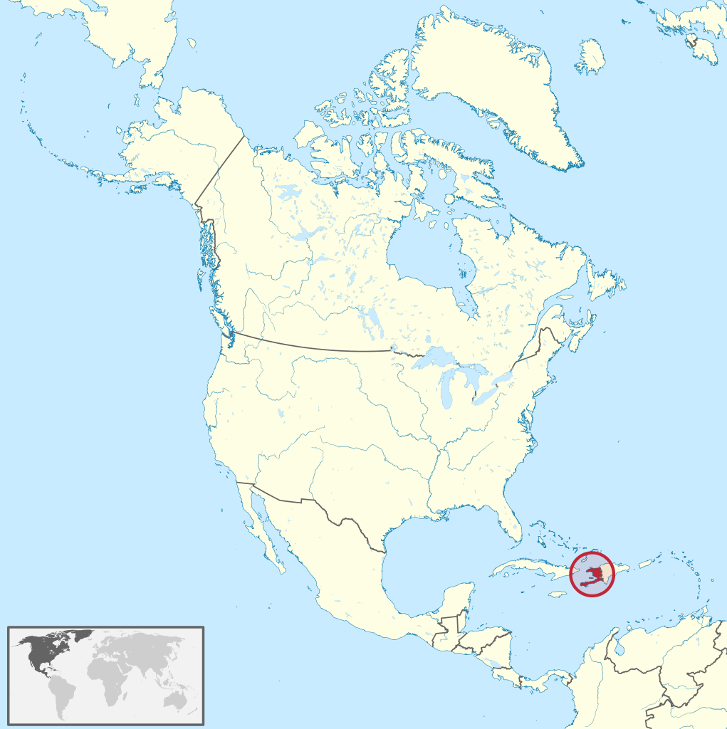
Haiti (/ˈheɪti/ ;Haitian Creole: Ayiti [ajiti]; French: Haïti [a.iti]), officially the Republic of Haiti (Haitian Creole: Repiblik d Ayiti); French: République d'Haïti) and formerly known as Hayti, is a country located on the island of Hispaniola in the Greater Antilles archipelago of the Caribbean Sea, east of Cuba and Jamaica, and south of The Bahamas and the Turks and Caicos Islands. It occupies the western three-eighths of the island which it shares with the Dominican Republic. To its south-west lies the small Navassa Island, which is claimed by Haiti but is disputed as a United States territory under federal administration. Haiti is 27,750 km2 (10,714 sq mi) in size, the third largest country in the Caribbean by area, and has an estimated population of 11.4 million, making it the most populous country in the Caribbean. The capital is Port-au-Prince. The island was originally inhabited by the indigenous Taíno people, who originated in South America. The first Europeans arrived on 5 December 1492 during the first voyage of Christopher Columbus, who initially believed he had found India or China. Columbus subsequently founded the first European settlement in the Americas, La Navidad, on what is now the northeastern coast of Haiti. The island was claimed by Spain and named La Española, forming part of the Spanish Empire until the early 17th century. However, competing claims and settlements by the French led to the western portion of the island being ceded to France in 1697, which was subsequently named Saint-Domingue. French colonists established lucrative sugarcane plantations, worked by vast numbers of slaves brought from Africa, which made the colony one of the richest in the world. (Source: Wikipedia.org, CC BY-SA)
Honduras, officially the Republic of Honduras, is a country in Central America. The republic of Honduras is bordered to the west by Guatemala, to the southwest by El Salvador, to the southeast by Nicaragua, to the south by the Pacific Ocean at the Gulf of Fonseca, and to the north by the Gulf of Honduras, a large inlet of the Caribbean Sea. Its capital and largest city is Tegucigalpa. Honduras was home to several important Mesoamerican cultures, most notably the Maya, before the Spanish Colonization in the sixteenth century. The Spanish introduced Catholicism and the now predominant Spanish language, along with numerous customs that have blended with the indigenous culture. Honduras became independent in 1821 and has since been a republic, although it has consistently endured much social strife and political instability, and remains one of the poorest countries in the Western Hemisphere. In 1960, the northern part of what was the Mosquito Coast was transferred from Nicaragua to Honduras by the International Court of Justice. (Source: Wikipedia.org, CC BY-SA)
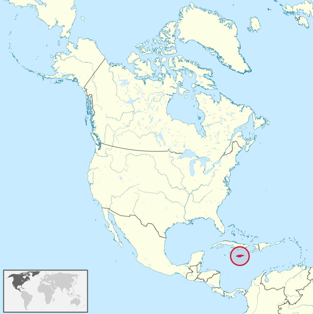
Jamaica (/dʒəˈmeɪkə/ ; Jamaican Patois: Jumieka) is an island country situated in the Caribbean Sea. Spanning 10,990 square kilometres (4,240 sq mi) in area, it is the third-largest island of the Greater Antilles and the Caribbean (after Cuba and Hispaniola). Jamaica lies about 145 kilometres (90 mi) south of Cuba, and 191 kilometres (119 mi) west of Hispaniola (the island containing the countries of Haiti and the Dominican Republic); the British Overseas Territory of the Cayman Islands lies some 215 kilometres (134 mi) to the north-west. With 2.8 million people, Jamaica is the third-most populous Anglophone country in the Americas (after the United States and Canada), and the fourth-most populous country in the Caribbean. Kingston is the country's capital and largest city. The majority of Jamaicans are of Sub-Saharan African ancestry, with significant European, East Asian (primarily Chinese), Indian, Lebanese, and mixed-race minorities. Due to a high rate of emigration for work since the 1960s, there is a large Jamaican diaspora, particularly in Canada, the United Kingdom, and the United States. The country has a global influence that belies its small size; it was the birthplace of the Rastafari religion, reggae music (and associated genres such as dub, ska and dancehall), and it is internationally prominent in sports, most notably cricket, sprinting and athletics. Jamaica is often considered the world's least populous cultural superpower. (Source: Wikipedia.org, CC BY-SA)
Martinique (/ˌmɑːrtɪˈniːk/ MAR-tin-EEK, French: [maʁtinik] ; Martinican Creole: Matinik or Matnik; Kalinago: Madinina or Madiana) is an island and an overseas department/region and single territorial collectivity of France. An integral part of the French Republic, Martinique is located in the Lesser Antilles of the West Indies in the eastern Caribbean Sea. It has a land area of 1,128 km2 (436 sq mi) and a population of 364,508 inhabitants as of January 2019. One of the Windward Islands, it is directly north of Saint Lucia, northwest of Barbados and south of Dominica. Martinique is an Outermost Region and a special territory of the European Union; the currency in use is the euro. Virtually the entire population speaks both French (the sole official language) and Martinican Creole. (Source: Wikipedia.org, CC BY-SA)
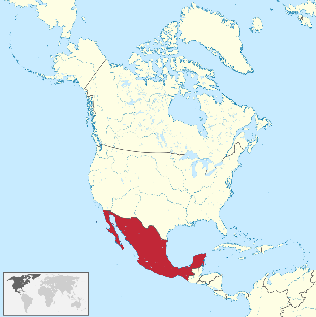
Mexico (Spanish: México), officially the United Mexican States, is a country in the southern portion of North America. It is bordered to the north by the United States; to the south and west by the Pacific Ocean; to the southeast by Guatemala, Belize, and the Caribbean Sea; and to the east by the Gulf of Mexico. Mexico covers 1,972,550 square kilometers (761,610 sq mi), making it the world's 13th-largest country by area; with approximately 126,014,024 inhabitants, it is the 10th-most-populous country and has the most Spanish-speakers. Mexico is organized as a federal republic comprising 31 states and Mexico City, its capital. Other major urban areas include Monterrey, Guadalajara, Puebla, Toluca, Tijuana, Ciudad Juárez, and León. Human presence in Pre-Columbian Mexico goes back to 8,000 BCE and it went to become one of the world's six cradles of civilization. In particular, the Mesoamerican region was home to many intertwined civilizations; including the Olmec, Maya, Zapotec, Teotihuacan, and Purepecha. Last were the Aztecs, who dominated the region in the century before European contact. In 1521, the Spanish Empire and its indigenous allies conquered the Aztec Empire from its capital Tenochtitlan (now Mexico City), establishing the colony of New Spain. Over the next three centuries, Spain and the Catholic Church played an important role expanding the territory, enforcing Christianity and spreading the Spanish language throughout. With the discovery of rich deposits of silver in Zacatecas and Guanajuato, New Spain soon became one of the most important mining centers worldwide. Wealth coming from Asia and the New World contributed to Spain's status as a major world power for the next centuries, and brought about a price revolution in Western Europe. The colonial order came to an end in the early nineteenth century with the War of Independence against Spain. (Source: Wikipedia.org, CC BY-SA)
Montserrat (/ˌmɒntsəˈræt/ MONT-sə-RAT) is a British Overseas Territory in the Caribbean. It is part of the Leeward Islands, the northern portion of the Lesser Antilles chain of the West Indies. Montserrat is about 16 km (10 mi) long and 11 km (7 mi) wide, with roughly 40 km (25 mi) of coastline. It is nicknamed 'The Emerald Isle of the Caribbean' both for its resemblance to coastal Ireland and for the Irish ancestry of many of its inhabitants. Montserrat is the only non-fully sovereign full member of the Caribbean Community and the Organisation of Eastern Caribbean States. On 18 July 1995, the previously dormant Soufrière Hills volcano, in the southern part of the island, became active. Eruptions destroyed Montserrat's Georgian era capital city of Plymouth. Between 1995 and 2000, two-thirds of the island's population was forced to flee, primarily to the United Kingdom, leaving fewer than 1,200 people on the island in 1997 (rising to nearly 5,000 by 2016). The volcanic activity continues, mostly affecting the vicinity of Plymouth, including its docking facilities, and the eastern side of the island around the former W. H. Bramble Airport, the remnants of which were buried by flows from volcanic activity on 11 February 2010. (Source: Wikipedia.org, CC BY-SA)
Navassa Island (/nəˈvæsə/; Haitian Creole: Lanavaz; French: l'île de la Navasse, sometimes la Navase) is a small uninhabited island in the Caribbean Sea. Located northeast of Jamaica, south of Cuba, and 40 nautical miles (74 km; 46 mi) west of Jérémie on the Tiburon Peninsula of Haiti, it is subject to an ongoing territorial dispute between Haiti and the United States, which administers the island through the U.S. Fish and Wildlife Service. The U.S. has claimed the island since 1857, based on the Guano Islands Act of 1856. However, Haiti's claim over Navassa goes back to the Treaty of Ryswick in 1697 that established French possessions on mainland Hispaniola from Spain by the treaty as well as other specifically named nearby islands. Its 1801 constitution claimed several nearby islands by name, among which Navassa was not listed, but also laid claim to 'other adjacent islands', which Haiti maintains included Navassa. The U.S. claim to the island, first made in 1857, asserts that Navassa was not included among the unnamed “other adjacent islands” in the Haitian Constitution of 1801. Since the Haitian Constitution of 1874, Haiti has explicitly named 'la Navase' as one of the territories it claims, and maintains that it has been claimed as part of Haiti continuously since 1801. Médéric Louis Élie Moreau de Saint-Méry, who was a member of the French Parliament best known for his publications on Saint-Domingue, referred to 'la Navasse' as a 'small island between Saint-Domingue and Jamaica' in 1798. (Source: Wikipedia.org, CC BY-SA)
Nicaragua (/ˌnɪkəˈrɑːɡwə, -ˈræɡ-, -ɡjuə/ ; Spanish: [nikaˈɾaɣwa] ), officially the Republic of Nicaragua (Spanish: República de Nicaragua (help·info)), is the largest country in the Central American isthmus, bordered by Honduras to the northwest, the Caribbean to the east, Costa Rica to the south, and the Pacific Ocean to the southwest. Managua is the country's capital and largest city. As of 2015, it was estimated to be the second largest city in Central America. The multi-ethnic population of six million includes people of mestizo, indigenous, European and African heritage. The main language is Spanish. Indigenous tribes on the Mosquito Coast speak their own languages and English. Originally inhabited by various indigenous cultures since ancient times, the region was conquered by the Spanish Empire in the 16th century. Nicaragua gained independence from Spain in 1821. The Mosquito Coast followed a different historical path, being colonized by the English in the 17th century and later coming under British rule. It became an autonomous territory of Nicaragua in 1860 and its northernmost part was transferred to Honduras in 1960. Since its independence, Nicaragua has undergone periods of political unrest, dictatorship, occupation and fiscal crisis, including the Nicaraguan Revolution of the 1960s and 1970s and the Contra War of the 1980s. (Source: Wikipedia.org, CC BY-SA)
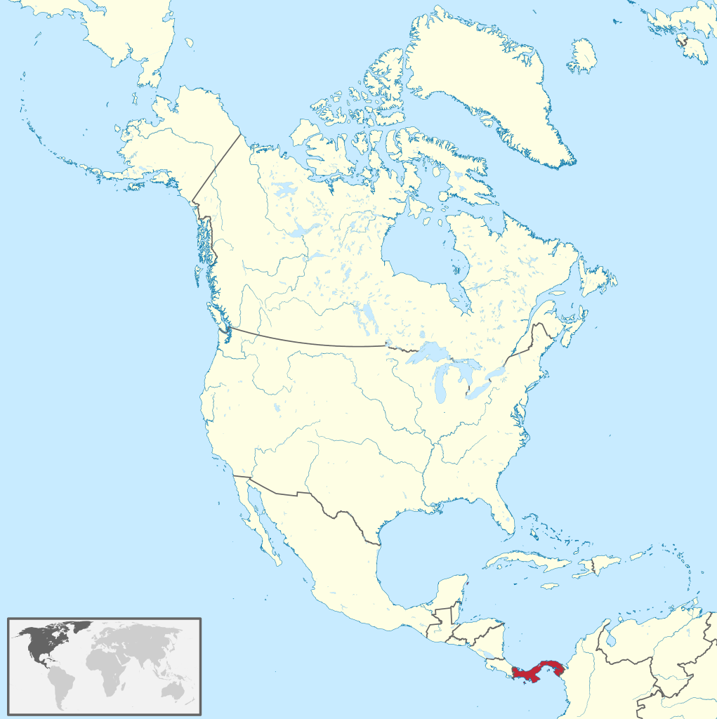
Panama (/ˈpænəmɑː/ PAN-ə-mah, /pænəˈmɑː/ pan-ə-MAH; Spanish: Panamá IPA: [panaˈma] ), officially the Republic of Panama (Spanish: República de Panamá), is a transcontinental country spanning the central part of North America and the northern part of South America. It is bordered by Costa Rica to the west, Colombia to the southeast, the Caribbean Sea to the north, and the Pacific Ocean to the south. Its capital and largest city is Panama City, whose metropolitan area is home to nearly half the country's 4 million people. Panama was inhabited by indigenous tribes before Spanish colonists arrived in the 16th century. It broke away from Spain in 1821 and joined the Republic of Gran Colombia, a union of Nueva Granada, Ecuador, and Venezuela. After Gran Colombia dissolved in 1831, Panama and Nueva Granada eventually became the Republic of Colombia. With the backing of the United States, Panama seceded from Colombia in 1903, allowing the construction of the Panama Canal to be completed by the United States Army Corps of Engineers between 1904 and 1914. The 1977 Torrijos–Carter Treaties agreed to transfer the canal from the United States to Panama on December 31, 1999. The surrounding territory was first returned in 1979. (Source: Wikipedia.org, CC BY-SA)
Puerto Rico (Spanish for 'rich port'; abbreviated PR; Taino: Boriken, Borinquen), officially the Commonwealth of Puerto Rico (Spanish: Estado Libre Asociado de Puerto Rico, lit. 'Free Associated State of Puerto Rico'), is a Caribbean island and unincorporated territory of the United States. It is located in the northeast Caribbean Sea, approximately 1,000 miles (1,600 km) southeast of Miami, Florida, between the Dominican Republic and the U.S. Virgin Islands, and includes the eponymous main island and several smaller islands, such as Mona, Culebra, and Vieques. It has roughly 3.2 million residents, and its capital and most populous city is San Juan. Spanish and English are the official languages of the executive branch of government, though Spanish predominates. Puerto Rico was settled by a succession of indigenous peoples beginning 2,000 to 4,000 years ago; these included the Ortoiroid, Saladoid, and Taíno. It was then colonized by Spain following the arrival of Christopher Columbus in 1493. Puerto Rico was contested by other European powers, but remained a Spanish possession for the next four centuries. An influx of African slaves and settlers primarily from the Canary Islands and Andalusia vastly changed the cultural and demographic landscape of the island. Within the Spanish Empire, Puerto Rico played a secondary but strategic role compared to wealthier colonies like Peru and New Spain. By the late 19th century, a distinct Puerto Rican identity began to emerge, centered around a fusion of indigenous, African, and European elements. In 1898, following the Spanish–American War, Puerto Rico was acquired by the United States. (Source: Wikipedia.org, CC BY-SA)
Saba (/ˈseɪbə/ ; Dutch: Saba, pronounced [ˈsaːbɑ] ) is a Caribbean island which is the smallest special municipality (officially “public body”) of the Netherlands. It consists largely of the active volcano Mount Scenery, which at 887 metres (2,910 ft) is the highest point of the entire Kingdom of the Netherlands. The island lies in the northern Leeward Islands portion of the West Indies, southeast of the Virgin Islands. Together with Bonaire and Sint Eustatius it forms the BES islands. Saba has a land area of 13 square kilometres (5.0 sq mi). The population was 1,933 in January 2020, with a population density of 148 inhabitants per square kilometre (380/sq mi). It is the smallest territory by permanent population in the Americas. Its towns and major settlements are The Bottom (the capital), Windwardside, Zion's Hill and St. Johns. (Source: Wikipedia.org, CC BY-SA)
Saint Barthélemy (French: Saint-Barthélemy, [sɛ̃ baʁtelemi]), officially the Collectivité territoriale de Saint-Barthélemy, is an overseas collectivity of France in the Caribbean. It is often abbreviated to St. Barth in French, and St. Barts in English. The island lies about 30 kilometres (19 mi) south of the Caribbean island Saint Martin, and is northeast of the Dutch islands of Saba, Sint Eustatius, and the independent country of Saint Kitts and Nevis. Saint Barthélemy was for many years a French commune forming part of Guadeloupe, which is an overseas region and department of France. In 2003 the island voted in favour of secession from Guadeloupe in order to form a separate overseas collectivity (collectivité d'outre-mer, abbreviated to COM) of France. The collectivity is one of four territories among the Leeward Islands in the northeastern Caribbean that make up the French West Indies, along with Saint Martin, Guadeloupe (200 kilometres (120 mi) southeast), and Martinique. (Source: Wikipedia.org, CC BY-SA)
Saint Kitts and Nevis (/-ˈkɪts ... ˈniːvɪs/ ), officially the Federation of Saint Christopher and Nevis, is an island country and microstate consisting of the two islands of Saint Kitts and Nevis, both located in the West Indies, in the Leeward Islands chain of the Lesser Antilles. With 261 square kilometers of territory, and roughly 50,000 inhabitants, it is the smallest sovereign state in the Western Hemisphere, in both area and population, as well as the world's smallest sovereign federation. The country is a Commonwealth realm, with Charles III as King and head of state. It is the only sovereign federation in the Caribbean. The capital city is Basseterre, located on the larger island of Saint Kitts. Basseterre is also the main port for passenger entry (via cruise ships) and cargo. The smaller island of Nevis lies approximately 3 km (2 mi) to the southeast of Saint Kitts, across a shallow channel called The Narrows. (Source: Wikipedia.org, CC BY-SA)
Saint Lucia (UK: /sənt luːˈsiːə, -ˈluːʃə/ , US: /seɪnt ˈluːʃə/ ; French: Sainte-Lucie) is an island country in the West Indies in the eastern Caribbean Sea on the boundary with the Atlantic Ocean. The island was previously called Iouanalao, the name given to the island by the native Arawaks, and later Hewanorra, the name given by the native Caribs, two separate Amerindian peoples. Part of the Windward Islands of the Lesser Antilles, it is located north/northeast of the island of Saint Vincent, northwest of Barbados and south of Martinique. It covers a land area of 617 km2 (238 square miles) and reported a population of 165,595 in the 2010 census. St. Lucia's largest city is Castries, its current capital, and its second largest is Soufrière, the first French colonial capital on the island. The French were the first Europeans to settle on the island. They signed a treaty with the native Island Caribs in 1660. England took control of the island from 1663 to 1667. In ensuing years, it was at war with France 14 times, and the rule of the island changed frequently. In 1814, the British took control of the island. Because it switched so often between British and French control, Saint Lucia was also known as the 'Helen of the West' after the Greek mythological character, Helen of Troy. (Source: Wikipedia.org, CC BY-SA)
Saint Martin (French: Saint-Martin; Dutch: Sint Maarten) is an island in the northeast Caribbean Sea, approximately 300 km (190 mi) east of Puerto Rico. The 87 square kilometres (34 sq mi) island is divided roughly 60:40 between the French Republic (53 square kilometres (20 sq mi)) and the Kingdom of the Netherlands (34 square kilometres (13 sq mi)), but the Dutch part is more populated than the French part. The division dates to 1648. The northern French part comprises the Collectivity of Saint Martin and is an overseas collectivity of the French Republic. As part of France, the French part of the island is also part of the European Union. The southern Dutch part comprises Sint Maarten and is one of four constituent countries that form the Kingdom of the Netherlands. On January 1, 2019, the population of the whole island was 73,777 inhabitants, with 41,177 living on the Dutch side and 32,489 on the French side. Note that the figure for the French side is based on censuses that took place after the devastation of Hurricane Irma in September 2017, whereas the figure for the Dutch side is only a post-censal estimate still based on the 2011 census. The first census since Hurricane Irma on the Dutch side of the island is scheduled to take place in October 2022.[citation needed] Population of the island on Jan. 1, 2017, before Hurricane Irma, was 75,869 (40,535 on the Dutch side, 35,334 on the French side). The island's traditional pre-colonial name is Oualichi which means 'the island of women'. (Source: Wikipedia.org, CC BY-SA)
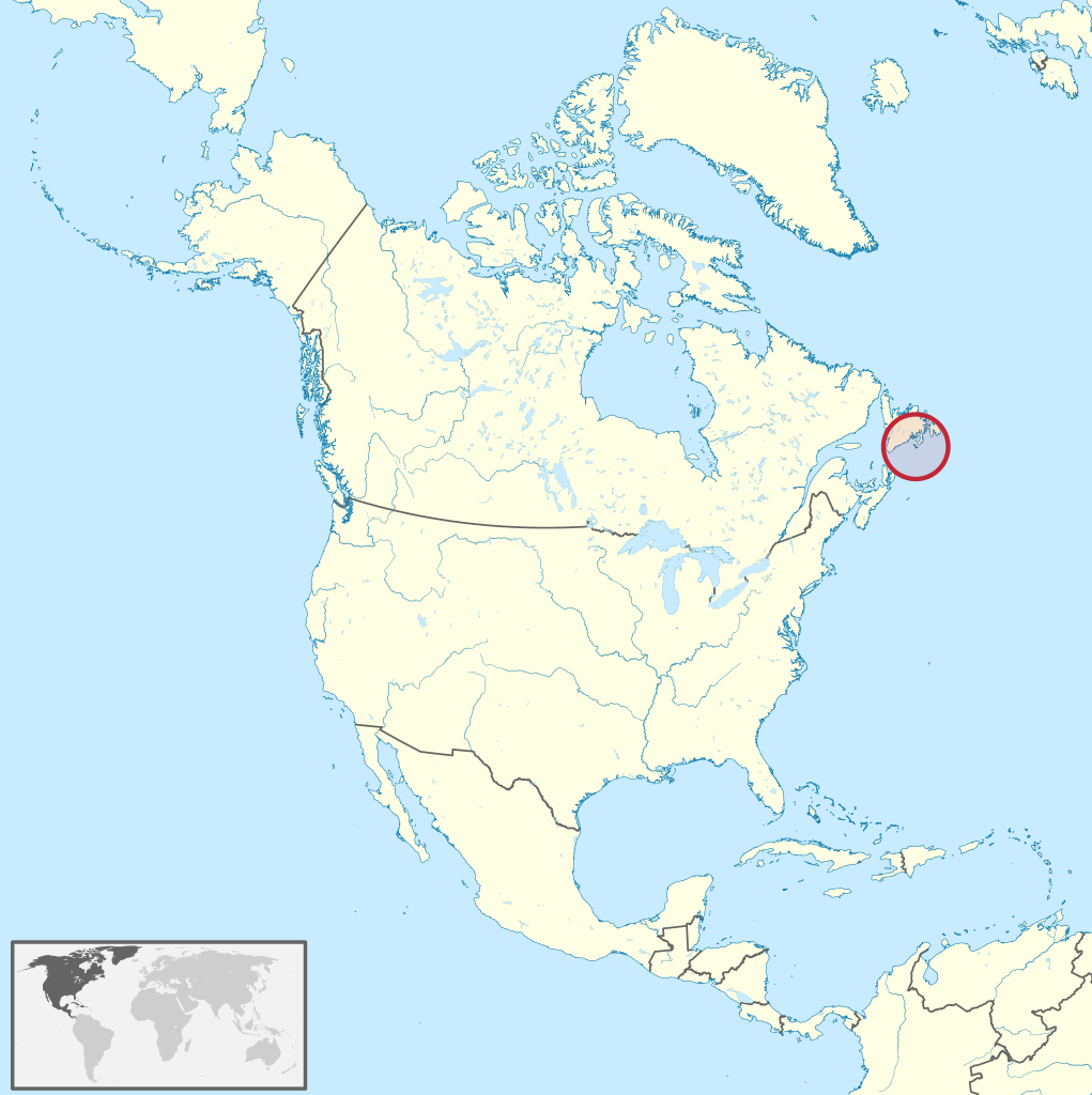
Saint Pierre and Miquelon (/ˈmɪkəlɒn/), officially the Territorial Collectivity of Saint-Pierre and Miquelon (French: Collectivité territoriale de Saint-Pierre et Miquelon [sɛ̃ pjɛʁ e miklɔ̃]), is a self-governing territorial overseas collectivity of France in the northwestern Atlantic Ocean near the Canadian province of Newfoundland and Labrador. Saint Pierre and Miquelon is a remaining vestige of the once-vast territory of New France. Its residents are French citizens; the collectivity elects its own deputy to the National Assembly and participates in senatorial and presidential elections. It covers 242 km2 (93 sq mi) of land and had a population of 6,008 as of the March 2016 census. The islands are in the Gulf of St. Lawrence near the entrance of Fortune Bay, which extends into the southwestern coast of Newfoundland, near the Grand Banks of Newfoundland. St. Pierre is 19 km (12 mi) from Point May on the Burin Peninsula of Newfoundland and 3,819 km (2,373 mi) from Brest, the nearest city in Metropolitan France. The tiny Canadian Green Island lies 10 km (6 mi) east of St. Pierre, roughly halfway to Point May. (Source: Wikipedia.org, CC BY-SA)
Saint Vincent and the Grenadines (/ˌɡrɛnəˈdiːnz/ ) is an island country in the Caribbean. It is located in the southeast Windward Islands of the Lesser Antilles, which lie in the West Indies at the southern end of the eastern border of the Caribbean Sea where the latter meets the Atlantic Ocean. Its 369 km2 (142 sq mi) territory consists of the main island of Saint Vincent and, south of that, two-thirds of the northern part of the Grenadines, a chain of 32 smaller islands. Some of the Grenadines are inhabited—Bequia, Mustique, Union Island, Canouan, Petit Saint Vincent, Palm Island, Mayreau, Young Island—while others are not: Tobago Cays, Baliceaux, Battowia, Quatre, Petite Mustique, Savan and Petit Nevis. Most of Saint Vincent and the Grenadines lies within the Hurricane Alley. To the north of Saint Vincent lies Saint Lucia, to the east is Barbados, and Grenada lies to the south. Saint Vincent and the Grenadines has a population density of over 300 inhabitants/km2 (700 per sq. mi.), with approximately 104,332 total inhabitants. (Source: Wikipedia.org, CC BY-SA)

Time for recess! Post a comment, ask a question or write a review. Feel free to let us know what you think!
look at the sign on the road to avoid accidents and horrible driving conditions
 -3
-3
I received a 300$ ticket because I passed a police control of other cars/drivers on the right lane of a highway (the control was on the hard shoulder of the highway). Is it really true, that you have to change the lane in such cases? Thanks!
I am an American living in Italy. The Italian Drivers License theory test is the hardest test I have ever studied for and I am in my 70s have multiple degrees, multiple professional certifications. Have to take the Italian Drivers Theory test in Italian. No english. So many rules. More signs in small medieval Italian town I live in then in major US cities I have lived in. No Italian license no driving. No buying or renting a car. Test here was good, clean. Lots of tricky questions on many practice and real official tests. Thanks
Most problems are a result of higher than safe driving speeds. Please just slow down and be patient.
Question 121: Poor translation: Vehicles with polluted fluids prohibited Should be translated as: Vehicles with dangerous liquids prohibited
Question 83: Poor translation: Vehicles with polluted fluids prohibited Should be translated as: Vehicles with dangerous liquids prohibited
0
Want even more practice? Visit similar websites offering realistic practice driving knowledge tests. Visit us to see what sets our tests apart! https://dkttest.com/capital-territory/
Cool tool! And fun to check whether I remember the rules :) Two things I noticed: Warning for a crossroad side roads on the left and right. While technically that might be the correct translation, this sign tells you, that you are on the main road and have the right of way for the next crossroad and only the next crossroad. Usually (if no sign specifies otherwise) you have to give way to drivers coming from the right at every intersection, which can get a bit annoying in communal areas, so seeing this sign feels less like a warning and more like relief :). A Fahrradstraße is not a lane for cyclists but a street for cyclists, meaning the (whole!) street is intended predominantly for cyclists, who are then allowed to ride next to each other. Cars are allowed to drive there (unless another sign prohibits such), but have to adjust their speed to the cyclists. I believe they are not allowed to pass at all, even if the oncoming lane is empty.


More community