

Here you can study for the exam. Look up keywords and learn definitions about all kind of subjects.
More subjects
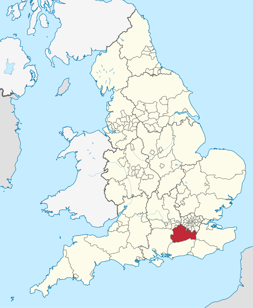
Surrey (/ˈsʌri/) is a ceremonial county in South East England. It is bordered by Greater London to the north east, Kent to the east, East and West Sussex to the south, and Hampshire and Berkshire to the west. The largest settlement is Woking. The county has an area of 1,663 km2 (642 sq mi) and a population of 1,196,236. Much of the north of the county forms part of the Greater London Built-up Area, which includes the suburbs within the M25 motorway as well as Woking (103,900), Guildford (77,057), and Leatherhead (32,522). The west includes part of the Farnborough/Aldershot built-up area, which extends into Hampshire and Berkshire and has a total population of 252,397. The south of the county is rural, and its largest settlements are Horley (22,693) and Godalming (22,689). For administrative purposes the county is two-tier and governed by Surrey County Council and eleven borough councils. The county historically included much of south-west Greater London and excluded Staines-upon-Thames, which was part of Middlesex. (Source: Wikipedia.org, CC BY-SA)
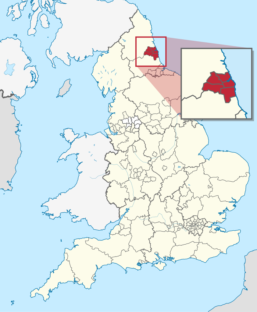
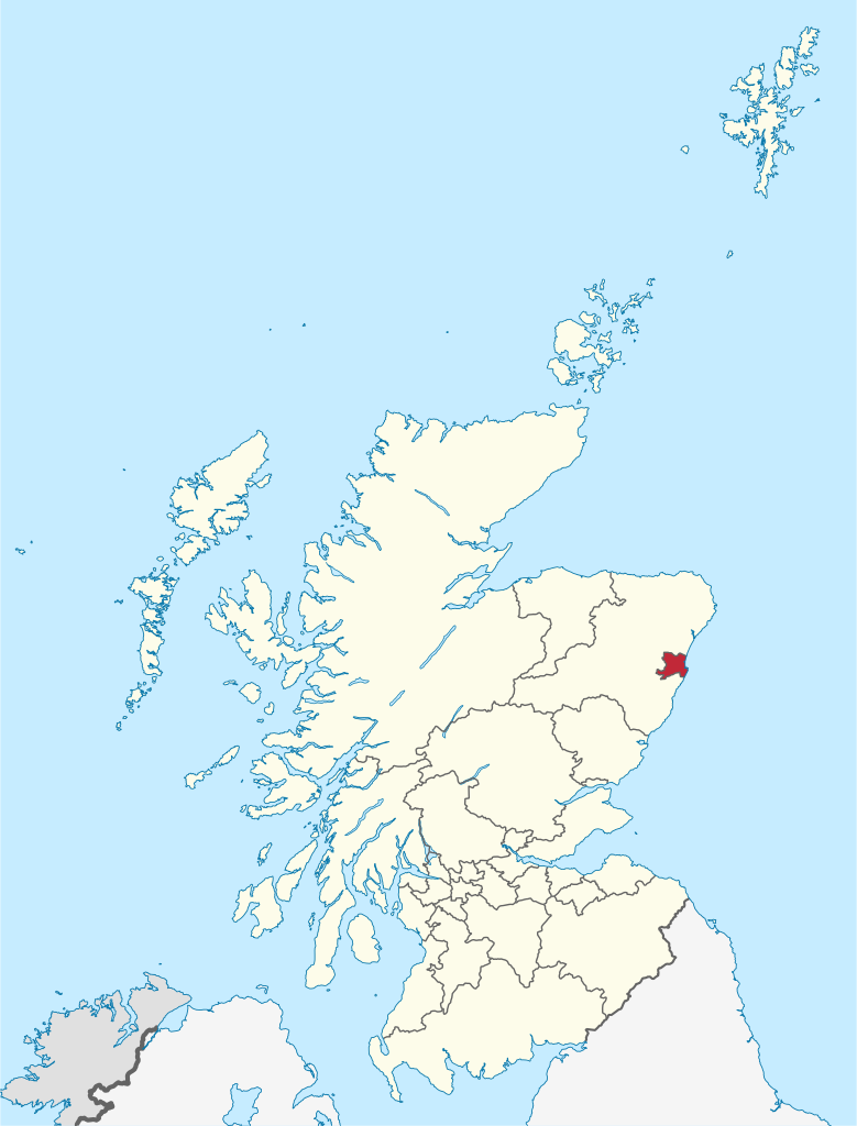
Tyne and Wear (/ˌtaɪn ... ˈwɪər/) is ceremonial county in North East England. It borders Northumberland to the north and County Durham to the south, and the largest settlement is the city of Newcastle-upon-Tyne. The county is heavily urbanised, with a population of 1.14 million in 2021. After Newcastle (300,125) the largest settlements are Sunderland (170,134), Gateshead (120,046), and South Shields (75,337). Nearly all of the county's settlements belong to either the Tyneside or Wearside conurbations, the latter of which also extends into County Durham. The county is governed by five metropolitan boroughs: Gateshead, Newcastle upon Tyne, Sunderland, North Tyneside and South Tyneside. The boroughs collaborate through two combined authorities: North of Tyne consists of Newcastle, North Tyneside, and Northumberland, and North East consists of the remaining boroughs and County Durham. The county was historically part of Northumberland and County Durham, with the River Tyne forming the border. (Source: Wikipedia.org, CC BY-SA)
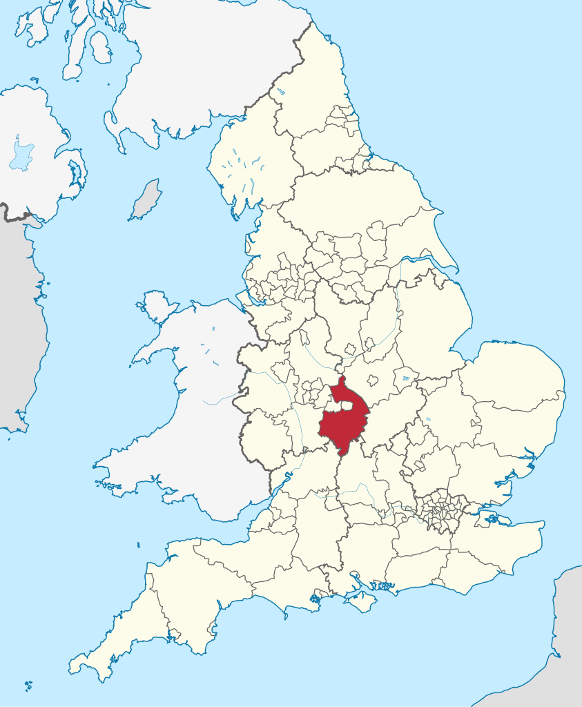
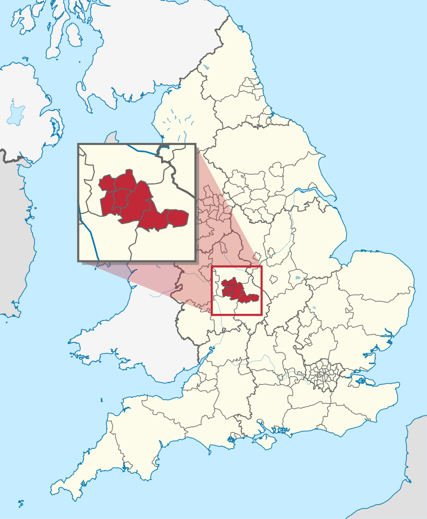
Warwickshire (/ˈwɒrɪkʃər, -ʃɪər/ ; abbreviated Warks) is a ceremonial county in the West Midlands of England. It borders Staffordshire and Leicestershire to the north, Northamptonshire to the east, Oxfordshire and Gloucestershire to the south, and Worcestershire and the West Midlands county to the west. The largest settlement is Nuneaton. The county is largely rural, and has an area of 1,975 km2 (763 sq mi) and population of 571,010. After Nuneaton (94,364) the largest settlements are Rugby (78,125), Royal Leamington Spa (57,512) and Warwick (37,267). For administrative purposes Warwickshire is a non-metropolitan county governed by Warwickshire County Council and five district councils. The historic county included the city of Coventry and the area to its west, including Sutton Coldfield, Solihull, and much of Birmingham. (Source: Wikipedia.org, CC BY-SA)
West Midlands is a ceremonial county in the larger West Midlands region of England. A landlocked county, it borders Staffordshire to the north and west, Worcestershire to the south, and is surrounded by Warwickshire to the east. The largest settlement is the city of Birmingham. The county is almost entirely urban, with an area of 902 square kilometres (348 sq mi) and a population of 2,919,600, making it the second most populous county in England after Greater London. After Birmingham (1,144,919) the largest settlements are the cities of Coventry (345,324) and Wolverhampton (263,700), Solihull (126,577), and Sutton Coldfield (109,899). Nearly all of the county's settlements belong to the West Midlands and Coventry built-up areas, though the 'Meriden Gap' between them is rural. The county is governed by its seven metropolitan boroughs, which collaborate through the West Midlands Combined Authority. The county was historically part of Staffordshire, Warwickshire, and Worcestershire. (Source: Wikipedia.org, CC BY-SA)
West Sussex is a ceremonial county in South East England. It is bordered by Surrey to the north, East Sussex to the east, the English Channel to the south, and Hampshire to the west. The county town is the city of Chichester, and the largest settlement is Worthing. The county has an area of 1,991 km2 (769 sq mi) and a population of 858,852. Along the south coast is a near-continuous urban area which includes the towns of Bognor Regis (63,855), Littlehampton (55,706), and Worthing (111,338); the latter two are part of the Brighton and Hove built-up area, which extends into East Sussex and has a total population of 474,485. The interior of the county is generally rural; the largest towns are Crawley (118,493) and Horsham (50,934), both in the north-east, and the city of Chichester in the south-west has a population of 26,795. For administrative purposes West Sussex is a two-tier non-metropolitan county governed by West Sussex County Council and seven district councils. West Sussex was historically united with East Sussex to form a single county. (Source: Wikipedia.org, CC BY-SA)
West Yorkshire is a ceremonial county in the Yorkshire and the Humber region of England. It borders North Yorkshire to the north and east, South Yorkshire and Derbyshire to the south, Greater Manchester to the south-west, and Lancashire to the west. The city of Leeds is the largest settlement. The county has an area of 2,029 km2 (783 sq mi) and a population of 2.3 million, making it the fourth-largest ceremonial county by population. Large parts of West Yorkshire are urban; many settlements are part of the West Yorkshire built-up area, which has a population of 1.78 million. The largest settlements are the cities of Leeds (516,298) and Bradford (366,187), Huddersfield (162,949), and the city of Wakefield (109,766). The west of the county is more rural. The county is governed by five metropolitan boroughs: City of Bradford, Calderdale, Kirklees, City of Leeds and City of Wakefield, which collaborate through West Yorkshire Combined Authority. (Source: Wikipedia.org, CC BY-SA)
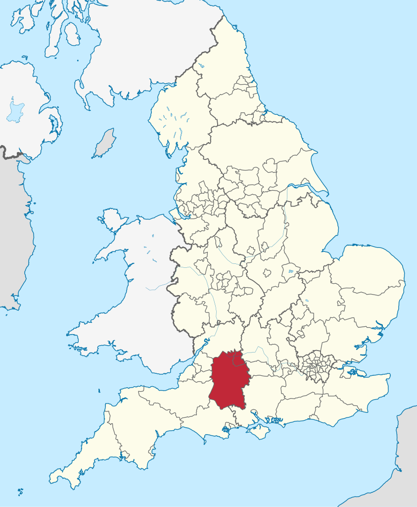
Wiltshire (/ˈwɪlt.ʃər, -ʃɪər/; abbreviated Wilts) is a ceremonial county in South West England. It borders Gloucestershire to the north, Oxfordshire and Berkshire to the east, Hampshire to the south-east, Dorset to the south, and Somerset to the west. The largest settlement is Swindon. The county has an area of 3,485 km2 (1,346 sq mi) and a population of 720,060. The county is mostly rural, and the centre and south-west are sparsely populated. After Swindon (183,638) the largest settlements are the city of Salisbury (41,820) and the towns of Chippenham (37,548) and Trowbridge (37,169). For administrative purposes the county is governed by two unitary authorities, Wiltshire Council and Swindon Borough Council. (Source: Wikipedia.org, CC BY-SA)
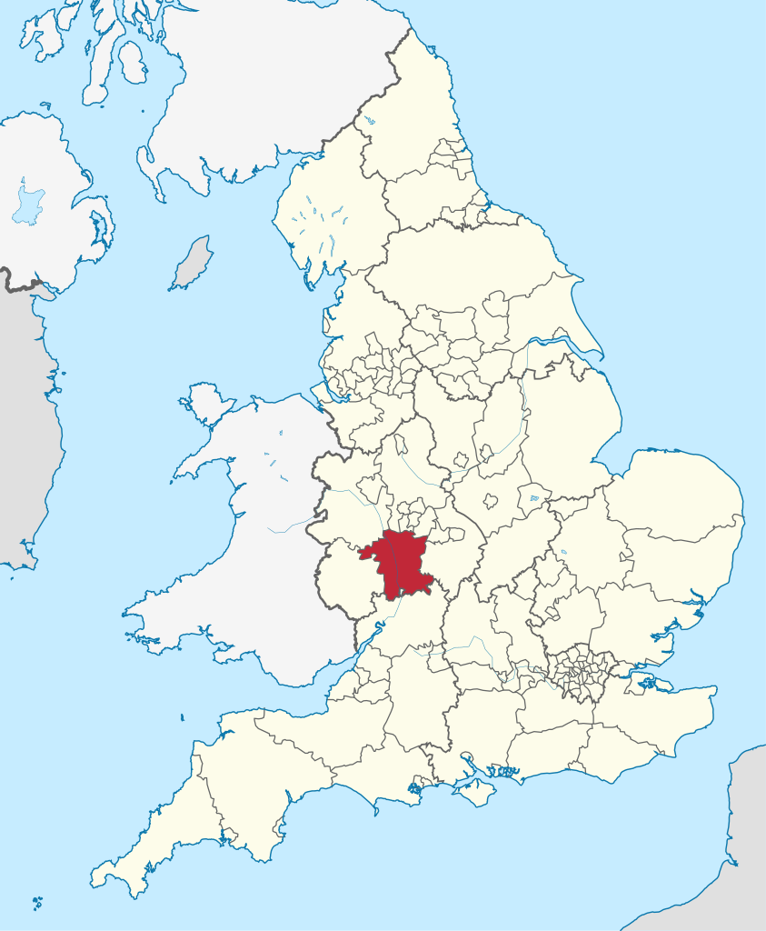
Worcestershire (/ˈwʊstərʃər/ WUSS-tər-shər, /-ʃɪər/ -sheer; written abbreviation: Worcs) is a ceremonial county in the West Midlands of England. It borders Shropshire, Staffordshire, and the West Midlands county to the north, Warwickshire to the east, Gloucestershire to the south, and Herefordshire to the west. The largest settlement is the city of Worcester. The county is largely rural, and has an area of 1,741 km2 (672 sq mi) and a population of 592,057. After Worcester (103,872) the largest settlements are Redditch (87,036), Kidderminster (57,400), and Malvern (30,462). For administrative purposes Worcestershire is a non-metropolitan county governed by Worcestershire County Council and six district councils. The historic county had complex boundaries, and included Stourbridge and the southwestern suburbs of Birmingham. (Source: Wikipedia.org, CC BY-SA)
Antrim and Newtownabbey is a local government district in Northern Ireland. The district was created on 1 April 2015 by merging the Borough of Antrim with the Borough of Newtownabbey. The local authority is Antrim and Newtownabbey Borough Council. The district stretches 274 square miles (710 km2) from the lower River Bann and Lough Neagh to the shores of Belfast Lough. It has a population of 142,492. The name of the new district was recommended on 17 September 2008. (Source: Wikipedia.org, CC BY-SA)
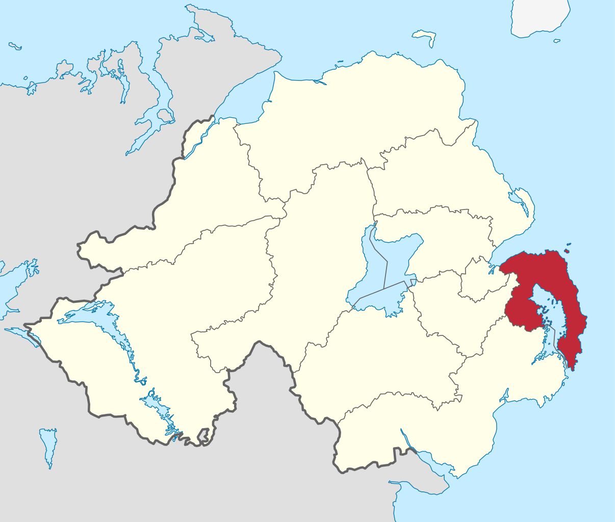
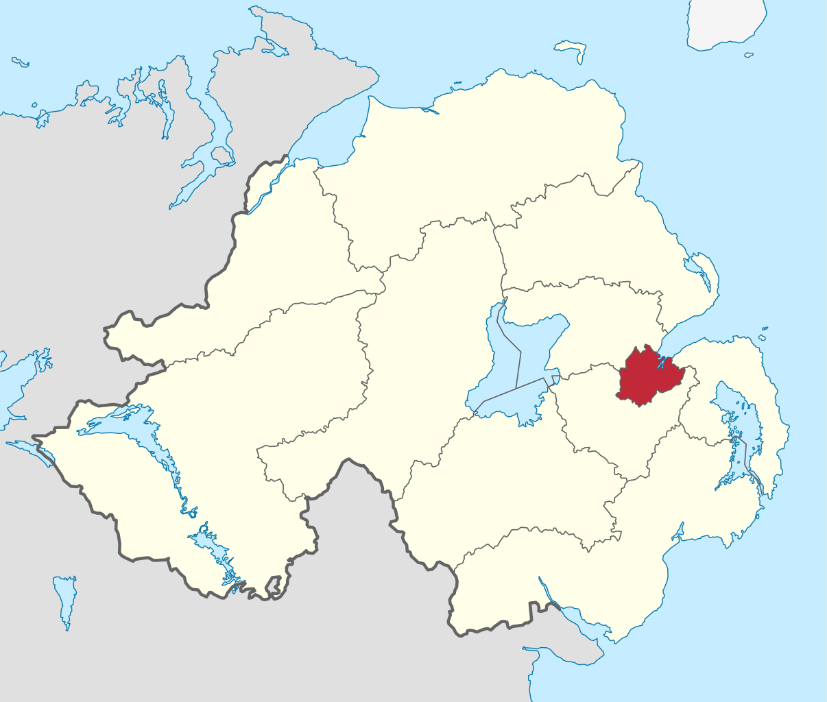
Ards and North Down is a local government district in Northern Ireland. It was created on 1 April 2015 by merging the Borough of Ards and the Borough of North Down. The local authority is Ards and North Down Borough Council. The new district is in the East of Northern Ireland, covering the Ards Peninsula, most of Strangford Lough and the southern shore of Belfast Lough. It has an estimated population of 160,864. The original name of the new district was recommended on 17 September 2008. (Source: Wikipedia.org, CC BY-SA)
Armagh City, Banbridge and Craigavon is a local government district in Northern Ireland. The district was created as Armagh, Banbridge and Craigavon on 1 April 2015 by merging the City and District of Armagh, Banbridge District and most of the Borough of Craigavon. The word 'City' was added to the name on 24 February 2016, to reflect Armagh's city status. The local authority is Armagh City, Banbridge and Craigavon Borough Council. The district covers parts of counties Armagh and Down, taking in the upper Bann valley and much of the southern shore of Lough Neagh as well as Armagh city. It has a population of 214,090. The name of the new district was announced on 17 September 2008. (Source: Wikipedia.org, CC BY-SA)
Belfast (/ˈbɛlfæst/ BEL-fast, /-fɑːst/ -fahst; from Irish: Béal Feirste [bʲeːlˠ ˈfʲɛɾˠ(ə)ʃtʲə], meaning 'mouth of the sand-bank ford') is the capital and largest city of Northern Ireland, standing on the banks of the River Lagan on the east coast. It is the 10th-largest primary urban area in the United Kingdom and the second-largest city in Ireland. The population of Belfast metropolitan area was 671,559 in 2011 and the City of Belfast had a population of 345,418 in 2021. (Source: Wikipedia.org, CC BY-SA)
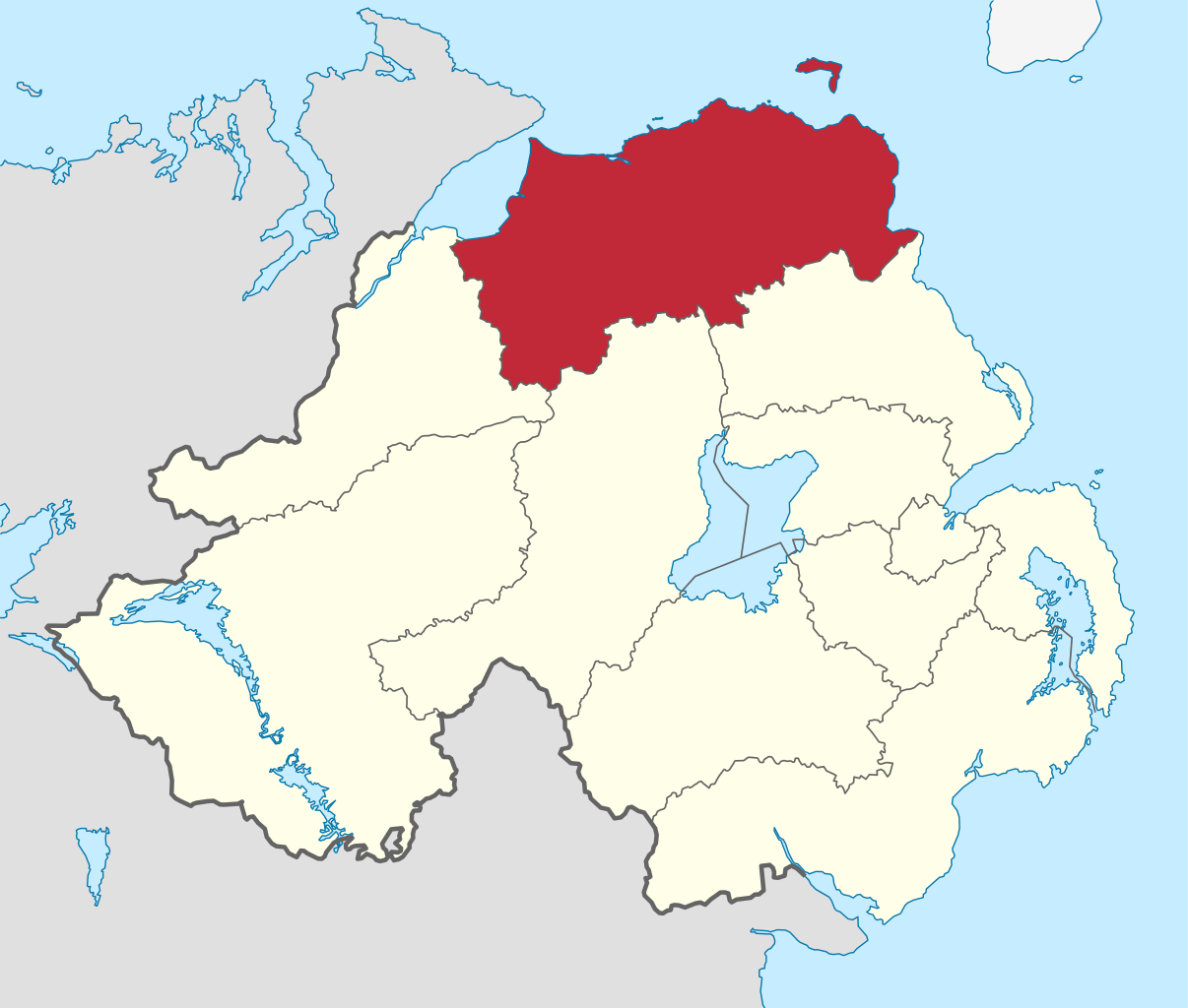
Causeway Coast and Glens is a local government district covering most of the northern part of Northern Ireland. It was created on 1 April 2015 by merging the Borough of Ballymoney, the Borough of Coleraine, the Borough of Limavady and the District of Moyle. The local authority is Causeway Coast and Glens Borough Council. The district covers most of the northern part of Northern Ireland; an area totalling 1796 km2 spanning parts of Counties Antrim and Londonderry. It has a population of around 144,246. The name of the new district was announced on 17 September 2008 as 'Causeway Coast' and was revised in February 2009. (Source: Wikipedia.org, CC BY-SA)
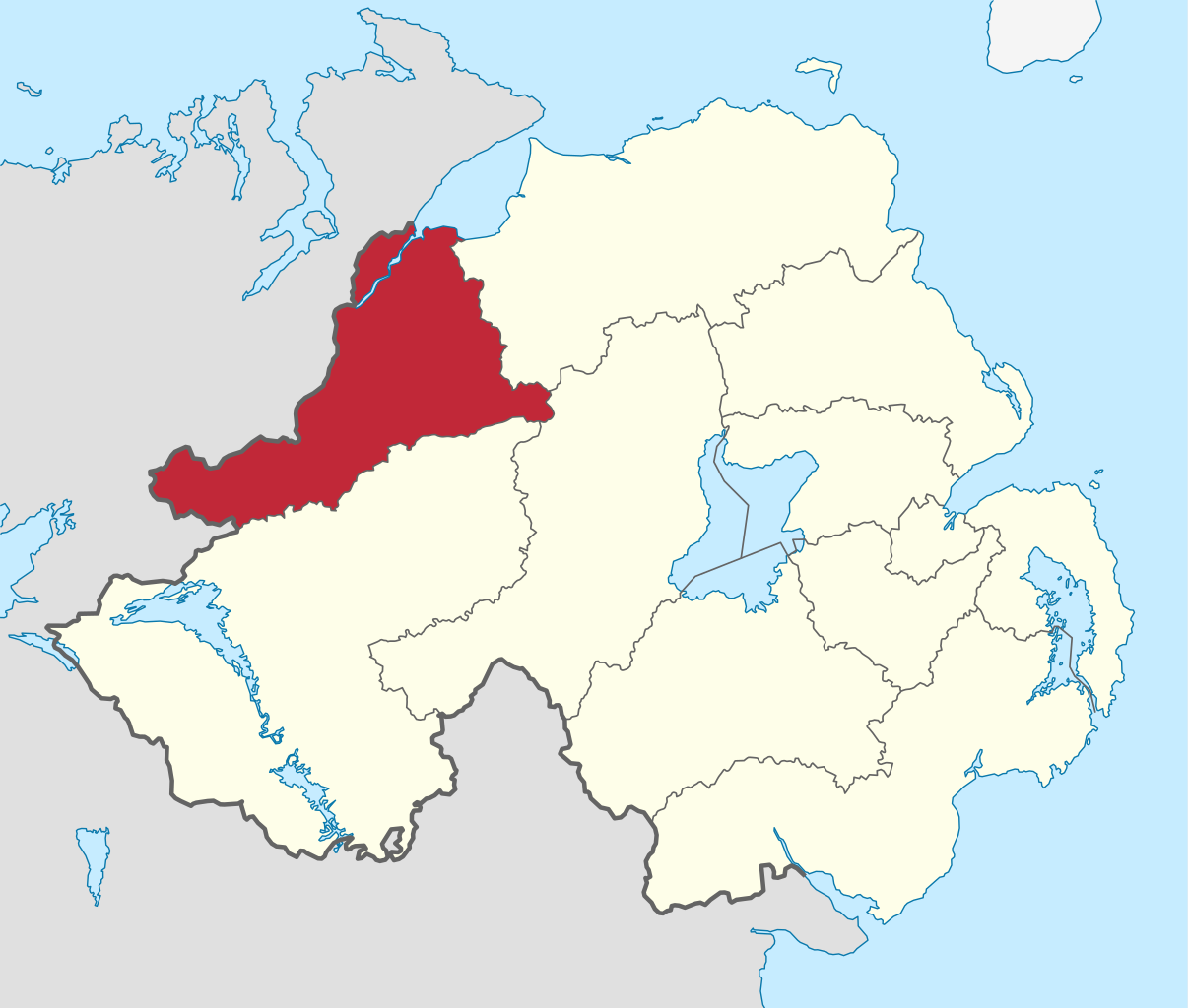
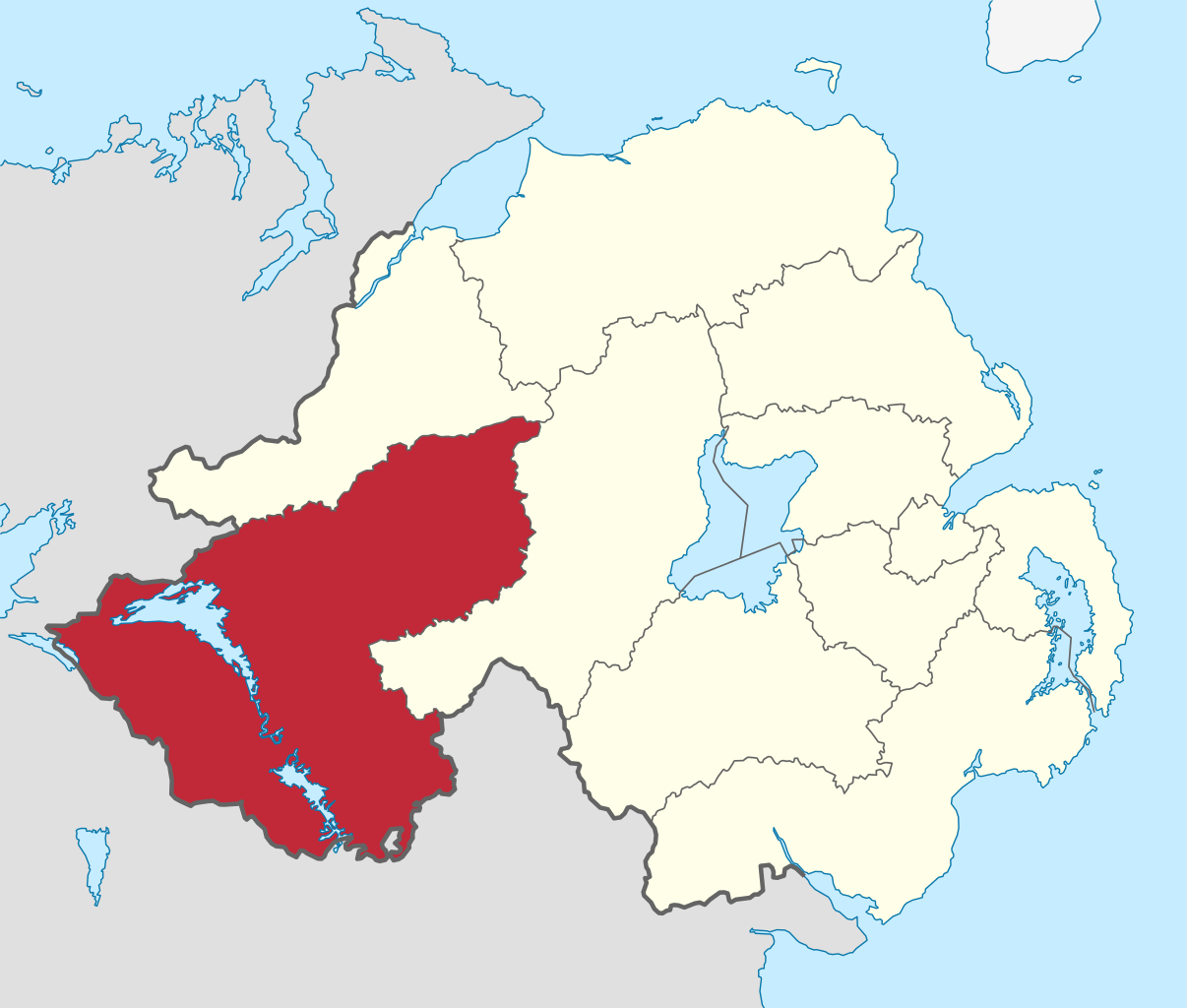
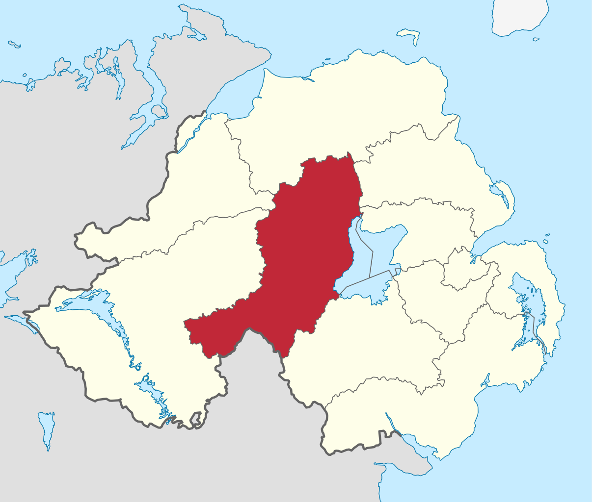
Derry City and Strabane is a local government district that was created on 1 April 2015 by merging the City of Derry District and Strabane District. It covers most of the northwest of Northern Ireland. The local authority is Derry City and Strabane District Council. It is located in the northwest of Northern Ireland and includes parts of counties Londonderry and Tyrone, and borders County Donegal in the Republic of Ireland. The district has a population of 150,679. The name of the new district was announced on 17 September 2008. Outside of Derry City the district is largely rural, containing a large swathe of the Sperrin Mountains which start at the market town of Strabane in County Tyrone. (Source: Wikipedia.org, CC BY-SA)
Fermanagh and Omagh (Irish: Comhairle Ceantair Fhear Manach agus na hÓmaí) is a local government district that was created on 1 April 2015 by merging Fermanagh District and Omagh District. It covers most of the Southwest of Northern Ireland. The local authority is Fermanagh and Omagh District Council, which likewise replaced Fermanagh District Council and Omagh District Council. It is located in the southwest of Northern Ireland, covering all of County Fermanagh and parts of County Tyrone. It borders counties Donegal, Leitrim, Cavan and Monaghan in the Republic of Ireland. The name of the new district was announced on 17 September 2008. (Source: Wikipedia.org, CC BY-SA)
Lisburn and Castlereagh is a local government district in Northern Ireland. The district was created on 1 April 2015. It consists of the combined area of the City of Lisburn with the Borough of Castlereagh, but not including 'the localities of Gilnahirk, Tullycarnet, Braniel, Castlereagh, Merok, Cregagh, Wynchurch, Glencregagh and Belvoir, Collin Glen, Poleglass, Lagmore, Twinbrook, Kilwee and Dunmurry' which transferred to Belfast. The local authority is Lisburn and Castlereagh City Council. The district takes in many of the outer suburbs of Belfast and had an electorate of 83,369 prior to its formation. The name of the new district was recommended on 17 September 2008. The area covered by the new Council has an estimated population of 144,381 residents. (Source: Wikipedia.org, CC BY-SA)
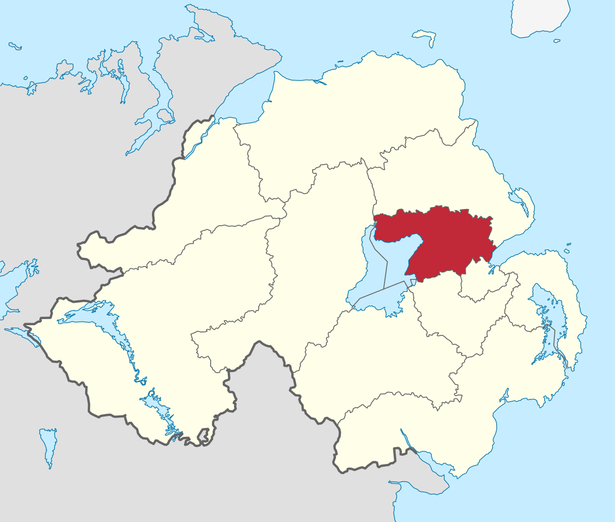
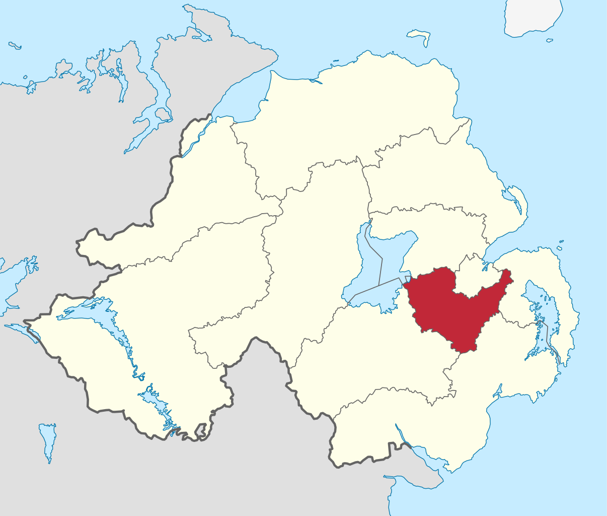
Mid Ulster (Irish: Ceantar Lár Uladh) is a local government district in Northern Ireland. The district was created on 1 April 2015 by merging Magherafelt District, Cookstown District, and the Borough of Dungannon and South Tyrone. The local authority is Mid Ulster District Council. The district covers parts of counties Londonderry, Tyrone, and Armagh, taking in the entire western shore of Lough Neagh, and bordering County Monaghan in the Republic of Ireland. The district has a population of 147,392. The name of the new district was announced on 17 September 2008. (Source: Wikipedia.org, CC BY-SA)
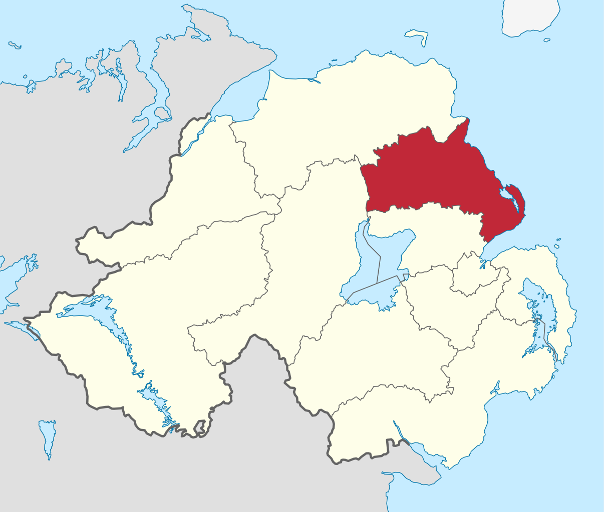
Mid and East Antrim is a local government district in Northern Ireland. The district was created on 1 April 2015 by merging the Borough of Ballymena, the Borough of Larne and the Borough of Carrickfergus. The local authority is Mid and East Antrim Borough Council. The district is wholly located in County Antrim, and stretches from the River Bann in the west to the Antrim Coast, taking in the southern part of the Antrim Coast and Glens Area of Outstanding Natural Beauty, as well as the major towns of Ballymena and Carrickfergus, and the important port of Larne. The district has a population of 138,773. The name of the new district was announced on 17 September 2008. (Source: Wikipedia.org, CC BY-SA)
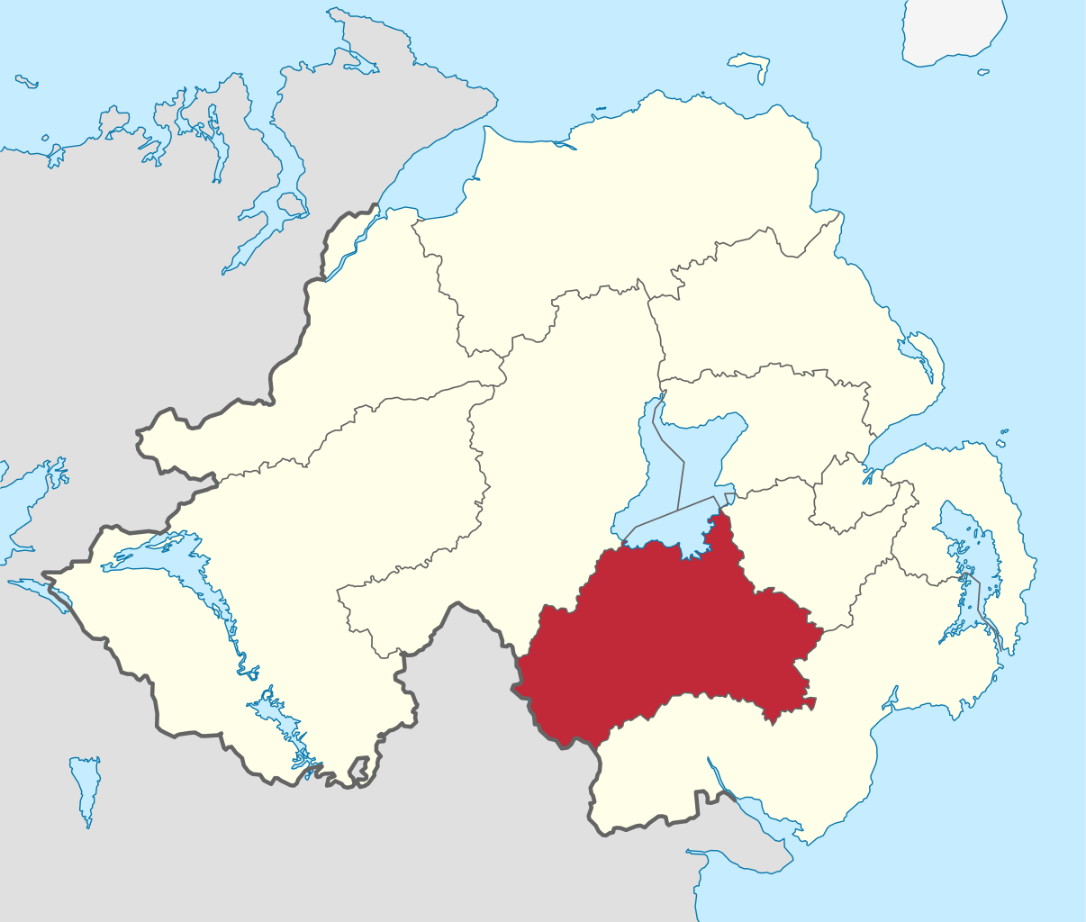
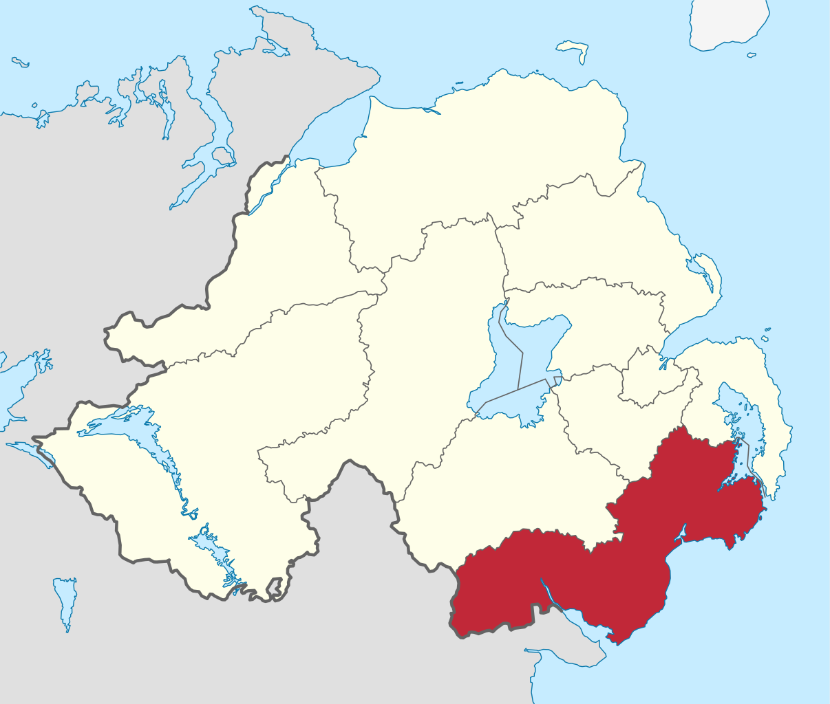
Newry, Mourne and Down is a local government district in Northern Ireland that was created on 1 April 2015 by merging Newry and Mourne District and Down District. It covers most of the southeastern part of Northern Ireland. The local authority is Newry, Mourne and Down District Council. The principle population centres are Newry in the south of the district, and Downpatrick in the north; both these urban areas were seats of previous council areas. It covers the Southeast of Northern Ireland, including southern County Armagh and large parts of County Down. It incorporates all of the Mourne Mountains and much of the Ring of Gullion, both designated as an Area of Outstanding Natural Beauty. The area has an extensive coastline stretching from Strangford Lough in the north to Carlingford Lough, in the south and borders counties Louth and Monaghan in the Republic of Ireland. The district has a population of 180,012. The name of the new district was announced on 17 September 2008. (Source: Wikipedia.org, CC BY-SA)
Aberdeen (/ˌæbərˈdiːn/ ; Scots: Aiberdeen [ˌeːbərˈdin] ; Scottish Gaelic: Obar Dheathain [ˈopəɾ ˈʝɛ.ɪɲ]; Latin: Aberdonia) is a city in North East Scotland, and is the third most populous city in the country. Aberdeen is one of Scotland's 32 local government council areas (as Aberdeen City), and has a 2020 population estimate of 198,590 for the city of Aberdeen, and 227,560 for the local council area making it the United Kingdom's 39th most populous built-up area. The city is 93 mi (150 km) northeast of Edinburgh and 398 mi (641 km) north of London, and is the northernmost major city in the United Kingdom. Aberdeen has a long, sandy coastline and features an oceanic climate, with cool summers and mild, rainy winters. (Source: Wikipedia.org, CC BY-SA)
Aberdeenshire (Scots: Aiberdeenshire; Scottish Gaelic: Siorrachd Obar Dheathain) is one of the 32 council areas of Scotland. It takes its name from the County of Aberdeen, which has substantially different boundaries. The Aberdeenshire Council area includes all of the area of the historic counties of Aberdeenshire and Kincardineshire (except the area making up Aberdeen City council area), as well as part of Banffshire. The county boundaries are officially used for a few purposes, namely land registration and lieutenancy. (Source: Wikipedia.org, CC BY-SA)
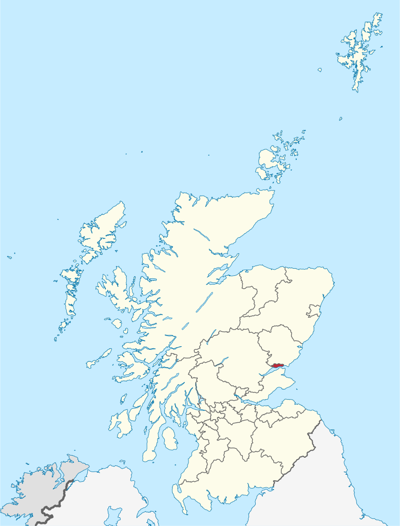
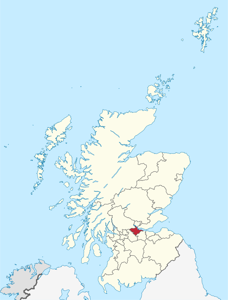
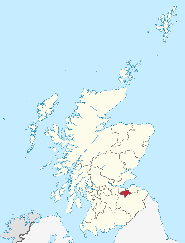
Angus (Scots: Angus; Scottish Gaelic: Aonghas) is one of the 32 local government council areas of Scotland, a registration county and a lieutenancy area. The council area borders Aberdeenshire, Dundee City and Perth and Kinross. Main industries include agriculture and fishing. Global pharmaceuticals company GSK has a significant presence in Montrose in the north of the county. Angus was historically a province, and later a sheriffdom and county (known officially as Forfarshire from the 18th century until 1928), bordering Kincardineshire to the north-east, Aberdeenshire to the north and Perthshire to the west; southwards it faced Fife across the Firth of Tay; these remain the borders of Angus, minus Dundee which now forms its own small separate council area. Angus remains a registration county and a lieutenancy area. In 1975 some of its administrative functions were transferred to the council district of the Tayside Region, and in 1995 further reform resulted in the establishment of the unitary Angus Council. (Source: Wikipedia.org, CC BY-SA)
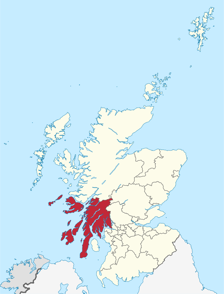
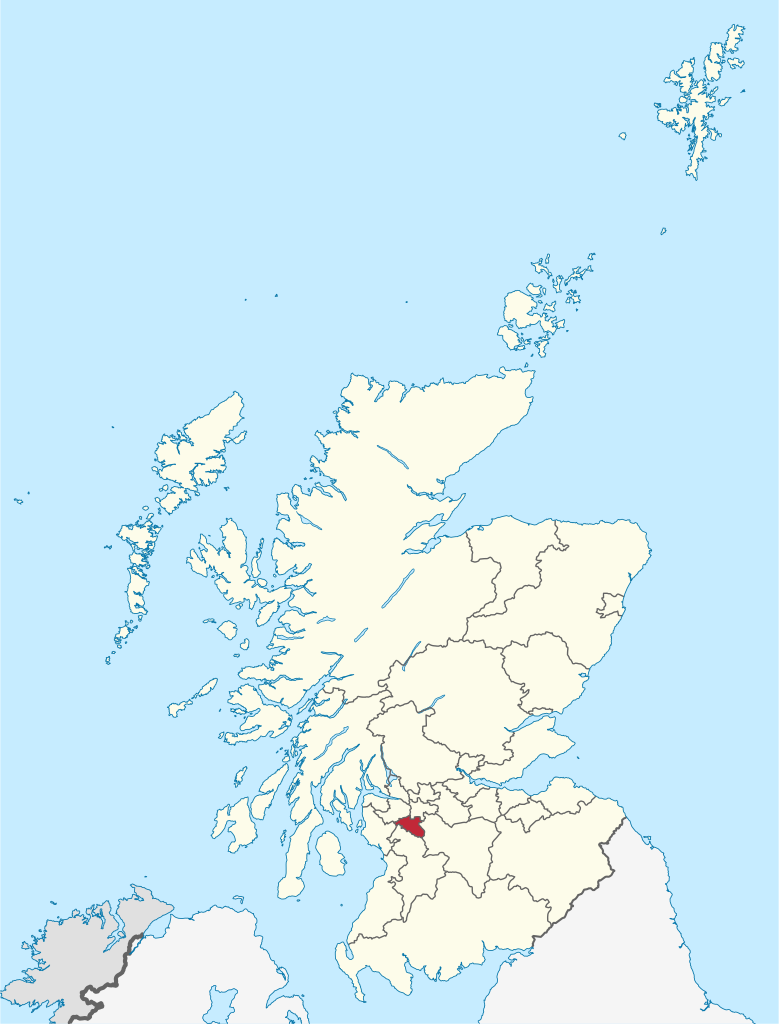
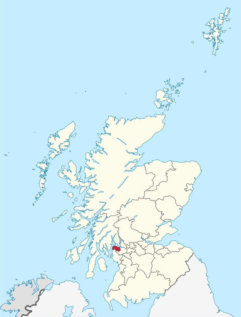
Argyll and Bute (Scots: Argyll an Buit; Scottish Gaelic: Earra-Ghàidheal agus Bòd, pronounced [ɛrˠəˈɣɛːəlˠ̪ akəs̪ ˈpɔːtʲ]) is one of 32 unitary council areas in Scotland and a lieutenancy area. The current lord-lieutenant for Argyll and Bute is Jane Margaret MacLeod (14 July 2020). The administrative centre for the council area is in Lochgilphead at Kilmory Castle, a 19th-century Gothic Revival building and estate. The current council leader is Robin Currie, a councillor for Kintyre and the Islands. Argyll and Bute covers the second-largest administrative area of any Scottish council. The council area adjoins those of Highland, Perth and Kinross, Stirling and West Dunbartonshire. (Source: Wikipedia.org, CC BY-SA)
Edinburgh (/ˈɛdɪnbərə/ ED-in-bər-ə, Scots: [ˈɛdɪnbʌrə]; Scottish Gaelic: Dùn Èideann [ˌt̪un ˈeːtʲən̪ˠ]) is the capital city of Scotland and one of its 32 council areas. The city was historically part of the county of Midlothian (formally called the 'county of Edinburgh' or Edinburghshire until 1947), but was administered separately from the surrounding county from 1482. It is located in Lothian on the southern shore of the Firth of Forth. Edinburgh is Scotland's second-most populous city, after Glasgow, and the seventh-most populous city in the United Kingdom. (Source: Wikipedia.org, CC BY-SA)
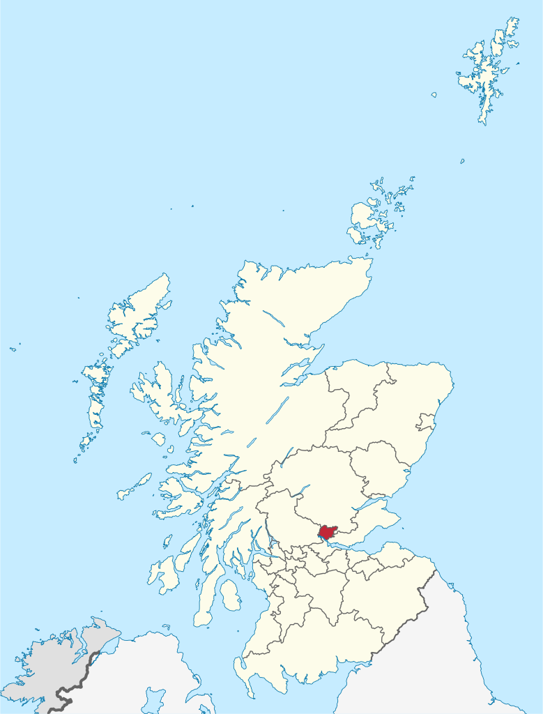
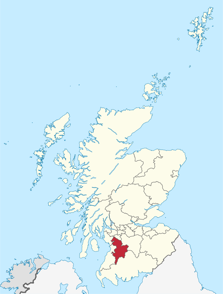
Clackmannanshire (/klækˈmænənˌʃɪər, -ʃər/ ; Scots: Clackmannanshire; Scottish Gaelic: Siorrachd Chlach Mhanann), or the County of Clackmannan, is a historic county, council area, registration county and lieutenancy area in Scotland, bordering the council areas of Stirling, Fife, and Perth and Kinross. In terms of historic counties it borders Perthshire, Stirlingshire and Fife. The name consists of elements from three languages. The first element is from Scottish Gaelic: Clach meaning 'Stone'. Mannan is a derivative of the Brythonic name of the Manaw, the Iron Age tribe who inhabited the area. The final element is the English word shire. As Britain's smallest historic county, it is often nicknamed 'The Wee County'. When written, Clackmannanshire is commonly abbreviated to Clacks. (Source: Wikipedia.org, CC BY-SA)
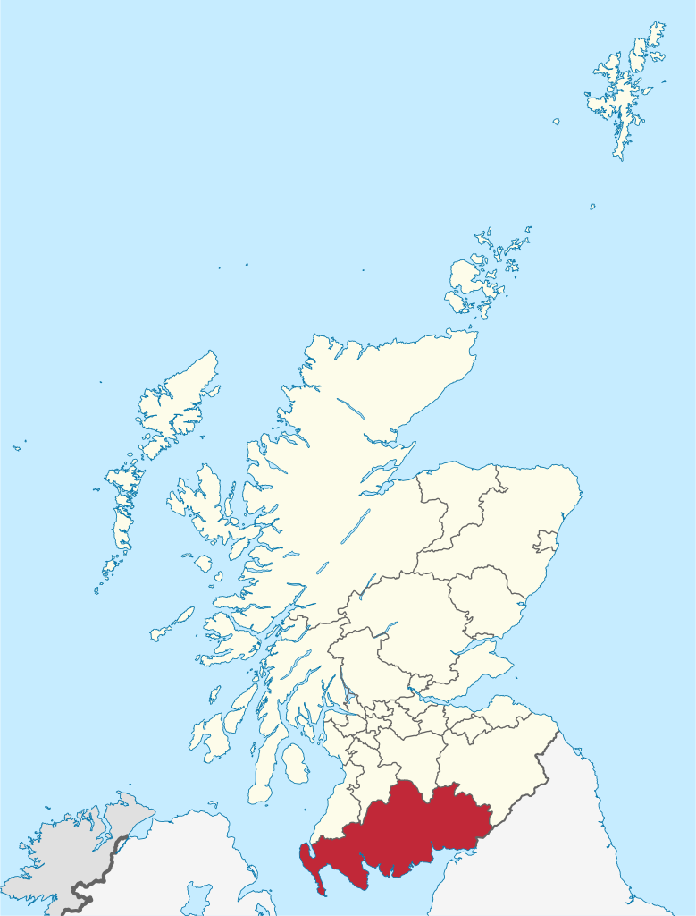
Dumfries and Galloway (Scots: Dumfries an Gallowa; Scottish Gaelic: Dùn Phrìs is Gall-Ghaidhealaibh) is one of 32 unitary council areas of Scotland and is located in the western Southern Uplands. It covers the historic counties of Dumfriesshire, Kirkcudbrightshire, and Wigtownshire, the latter two of which are collectively known as Galloway. The administrative centre and largest settlement is the town of Dumfries. The second largest town is Stranraer, on the North Channel coast, some 57 miles (92 km) to the west of Dumfries. Following the 1975 reorganisation of local government in Scotland, the three counties were joined to form a single region of Dumfries and Galloway, with four districts within it. The districts were abolished in 1996, since when Dumfries and Galloway has been a unitary local authority. For lieutenancy purposes, the area is divided into three lieutenancy areas called Dumfries, Wigtown and the Stewartry of Kirkcudbright, broadly corresponding to the three historic counties. (Source: Wikipedia.org, CC BY-SA)
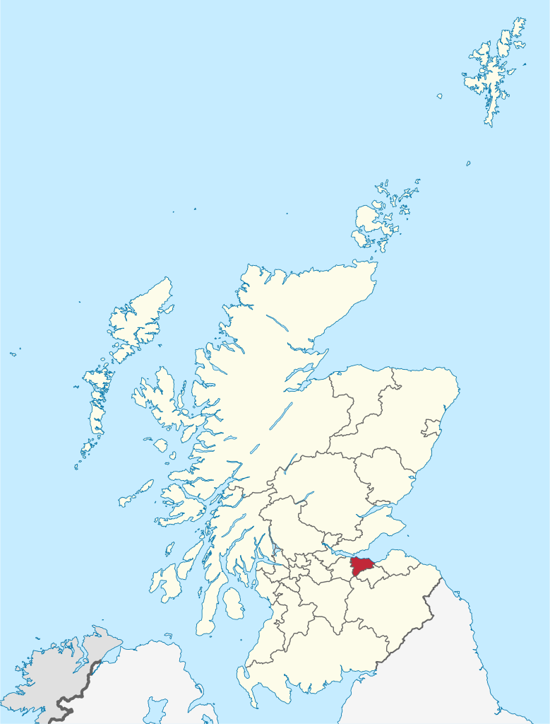
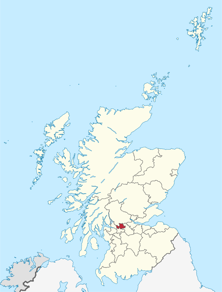
Dundee City Council is the local government authority for the City of Dundee. It was created in 1996 under the Local Government etc. (Scotland) Act 1994. Dundee City became a single-tier council in 1996, under the Local Government etc. (Scotland) Act 1994, with the boundaries of the City of Dundee district of the Tayside region, minus a Monifieth area and part of a Sidlaw area, which were transferred from the city area to the new council area of Angus. The city district was also the administrative centre for the region. (Source: Wikipedia.org, CC BY-SA)
East Ayrshire (Scots: Aest Ayrshire; Scottish Gaelic: Siorrachd Àir an Ear) is one of 32 unitary council areas of Scotland. It shares borders with Dumfries and Galloway, East Renfrewshire, North Ayrshire, South Ayrshire and South Lanarkshire. The headquarters of the council are located on London Road, Kilmarnock. With South Ayrshire and the mainland areas of North Ayrshire, it formed the former county of Ayrshire. East Ayrshire had a population of 122,100 at the 2011 census, making it the 16th most populous local authority in Scotland. Spanning a geographical area of 1,262 km2 (487 sq mi), East Ayrshire is the 14th-largest local authority in Scotland in terms of geographical area. The majority of the population of East Ayrshire live within and surrounding the main town, Kilmarnock. Other large population areas in East Ayrshire include Cumnock, the second-largest town, and smaller towns and villages such as Stewarton, Darvel and Hurlford. (Source: Wikipedia.org, CC BY-SA)
East Dunbartonshire (Scots: Aest Dunbartanshire; Scottish Gaelic: Siorrachd Dhùn Bhreatainn an Ear) is one of the 32 council areas of Scotland. It borders Glasgow City council area to the south, North Lanarkshire to the east, Stirling to the north and West Dunbartonshire to the west. East Dunbartonshire contains many of the affluent areas north of Glasgow, including Bearsden, Milngavie, Milton of Campsie, Balmore and Torrance, as well as many of the Glasgow's commuter towns and villages. The council area covers parts of the historic counties of Dunbartonshire, Lanarkshire and Stirlingshire. (Source: Wikipedia.org, CC BY-SA)
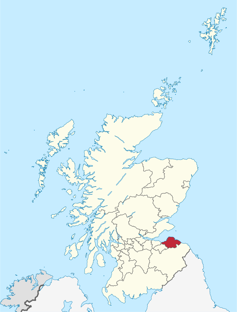
East Lothian (/ˈloʊðiən/; Scots: East Lowden; Scottish Gaelic: Lodainn an Ear) is one of the 32 council areas of Scotland, as well as a historic county, registration county and lieutenancy area. The county was called Haddingtonshire until 1921. In 1975, the historic county was incorporated for local government purposes into Lothian Region as East Lothian District, with some slight alterations of its boundaries. The Local Government etc. (Scotland) Act 1994 later created East Lothian as one of 32 modern council areas. East Lothian lies south of the Firth of Forth in the eastern central Lowlands of Scotland. It borders Edinburgh to the west, Midlothian to the south-west and the Scottish Borders to the south. Its administrative centre and former county town is Haddington while the largest town is Musselburgh. (Source: Wikipedia.org, CC BY-SA)
East Renfrewshire (Scots: Aest Renfrewshire; Scottish Gaelic: Siorrachd Rinn Friù an Ear) is one of 32 council areas of Scotland. It was formed in 1996, as a successor to the Eastwood district of the Strathclyde region. The northeastern part of the council area is close to Glasgow and many of the council area's northern settlements fall into the Greater Glasgow urban area. Clockwise, East Renfrewshire borders Glasgow City council area to the northeast, South Lanarkshire to the southeast, East Ayrshire to the southwest, North Ayrshire to the west and Renfrewshire to the northwest. (Source: Wikipedia.org, CC BY-SA)
Falkirk (/ˈfɔːlkɜːrk/; Scots: Fawkirk; Scottish Gaelic: An Eaglais Bhreac) is one of 32 unitary authority council areas of Scotland. It was formed on 1 April 1996 by way of the Local Government etc. (Scotland) Act 1994 from the exact boundaries of Falkirk District, one of three parts of the Central region created in 1975, which was abolished at that time. Prior to the 1975 reorganisation, the majority of the council area was part of the historic county of Stirlingshire, and a small part, namely Bo'ness and Blackness, was part of the former county of West Lothian. The council area borders with North Lanarkshire, Stirling and West Lothian, and, across the Firth of Forth to the northeast, Clackmannanshire and Fife. The largest town is Falkirk; other settlements, most of which surround Falkirk within 6 miles (9.7 km) of its centre, include Bo'ness, Bonnybridge, Denny, Grangemouth, Larbert, Polmont, Shieldhill, Camelon and Stenhousemuir. (Source: Wikipedia.org, CC BY-SA)
Fife (/faɪf/ FYFE, Scottish English: [fɐi̯f]; Scottish Gaelic: Fìobha, IPA: [fiːvə]; Scots: Fife) is a council area, historic county, registration county and lieutenancy area of Scotland. It is situated between the Firth of Tay and the Firth of Forth, with inland boundaries with Perth and Kinross (i.e. the historic counties of Perthshire and Kinross-shire) and Clackmannanshire. By custom it is widely held to have been one of the major Pictish kingdoms, known as Fib, and is still commonly known as the Kingdom of Fife within Scotland. A person from Fife is known as a Fifer. In older documents the county was very occasionally known by the anglicisation Fifeshire. Fife is Scotland's third largest local authority area by population. It has a resident population of just under 367,000, over a third of whom live in the three principal settlements, Dunfermline, Kirkcaldy and Glenrothes. (Source: Wikipedia.org, CC BY-SA)
Glasgow (UK: /ˈɡlɑːzɡoʊ, ˈɡlæz-, ˈɡlɑːs-, ˈɡlæs-/ GLA(H)Z-goh, GLA(H)SS-; Scots: Glesca [ˈɡleskə] or Glesga [ˈɡlezɡə]; Scottish Gaelic: Glaschu [ˈkl̪ˠas̪əxu]) is the most populous city in Scotland and the fourth-most populous city in the United Kingdom, as well as being the 27th largest city by population in Europe. In 2020, it had an estimated metro population of 1,861,315, The city was made a county of itself in 1893, prior to which it had been in the historic county of Lanarkshire. The city now forms the Glasgow City Council area, one of the 32 council areas of Scotland, and is governed by Glasgow City Council. It is situated on the River Clyde in the country's West Central Lowlands. (Source: Wikipedia.org, CC BY-SA)
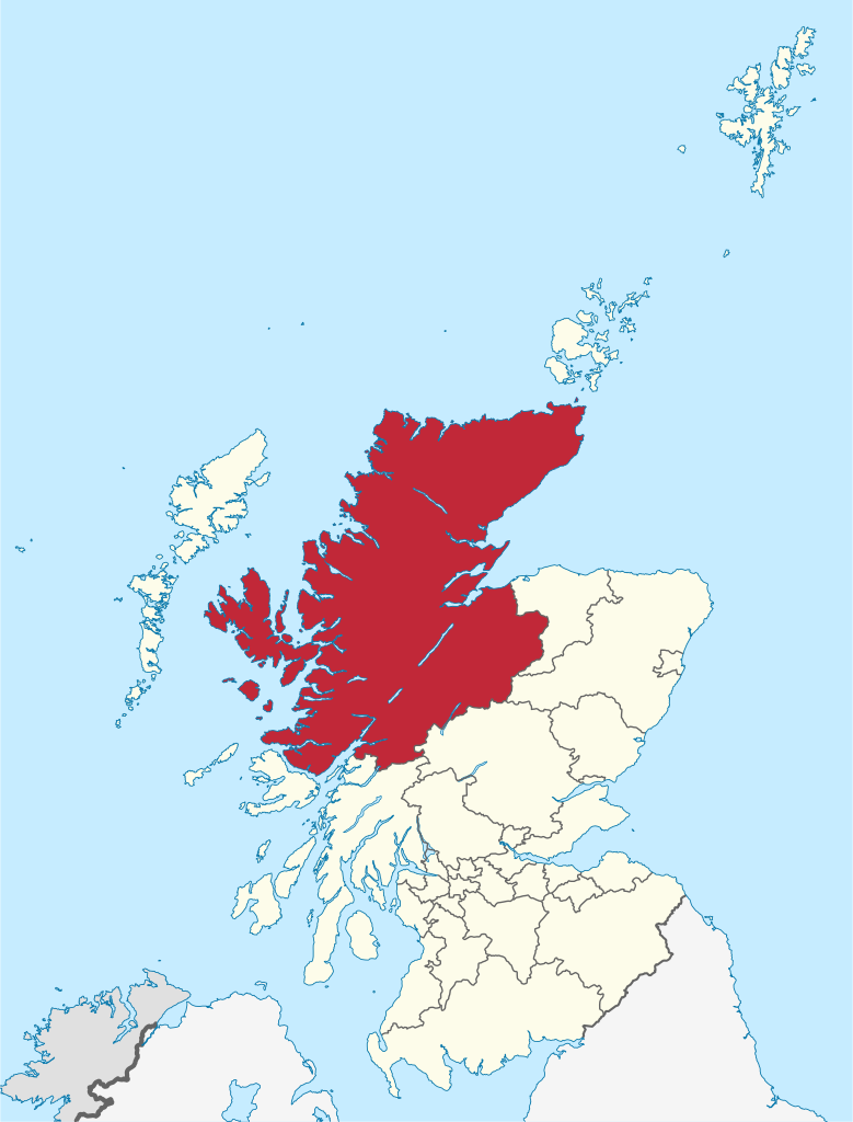
Highland (Scottish Gaelic: Gàidhealtachd, pronounced [ˈkɛːəl̪ˠt̪əxk]; Scots: Hieland) is a council area in the Scottish Highlands and is the largest local government area in the United Kingdom. It was the 7th most populous council area in Scotland at the 2011 census. It shares borders with the council areas of Aberdeenshire, Argyll and Bute, Moray and Perth and Kinross. Their councils, and those of Angus and Stirling, also have areas of the Scottish Highlands within their administrative boundaries. The Highland area covers most of the mainland and inner-Hebridean parts of the historic counties of Inverness-shire and Ross and Cromarty, all of Caithness, Nairnshire and Sutherland and small parts of Argyll and Moray. Despite its name, the area does not cover the entire Scottish Highlands. (Source: Wikipedia.org, CC BY-SA)
Inverclyde (Scots: Inerclyde, Scottish Gaelic: Inbhir Chluaidh, pronounced [iɲiɾʲˈxlˠ̪uəj], 'mouth of the Clyde') is one of 32 council areas used for local government in Scotland. Together with the East Renfrewshire and Renfrewshire council areas, Inverclyde forms part of the historic county of Renfrewshire, which currently exists as a registration county and lieutenancy area. Inverclyde is located in the west central Lowlands. It borders the North Ayrshire and Renfrewshire council areas, and is otherwise surrounded by the Firth of Clyde. (Source: Wikipedia.org, CC BY-SA)
Midlothian (/mɪdˈloʊðiən/; Scottish Gaelic: Meadhan Lodainn) is an historic county, registration county, lieutenancy area and one of 32 council areas of Scotland used for local government. Midlothian lies in the east-central Lowlands, bordering the City of Edinburgh council area, East Lothian and the Scottish Borders. Midlothian emerged as a county in the Middle Ages under larger boundaries than the modern council area, including Edinburgh itself. The county was formally called the 'shire of Edinburgh' or Edinburghshire until the twentieth century. It bordered West Lothian to the west, Lanarkshire, Peeblesshire and Selkirkshire to the south, and East Lothian, Berwickshire and Roxburghshire to the east. Traditional industries included mining, agriculture and fishing – although the modern council area is now landlocked. (Source: Wikipedia.org, CC BY-SA)
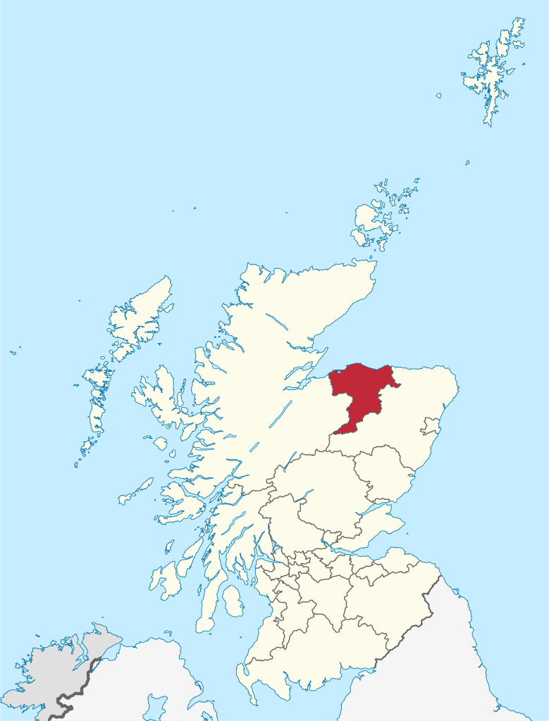
Moray (/ˈmʌri/ listen (help·info)) Scottish Gaelic: Moireibh or Moireabh) is one of the 32 local government council areas of Scotland. It lies in the north-east of the country, with a coastline on the Moray Firth, and borders the council areas of Aberdeenshire and Highland. Between 1975 and 1996 Moray, with similar boundaries, was a district of the then Grampian Region. (Source: Wikipedia.org, CC BY-SA)
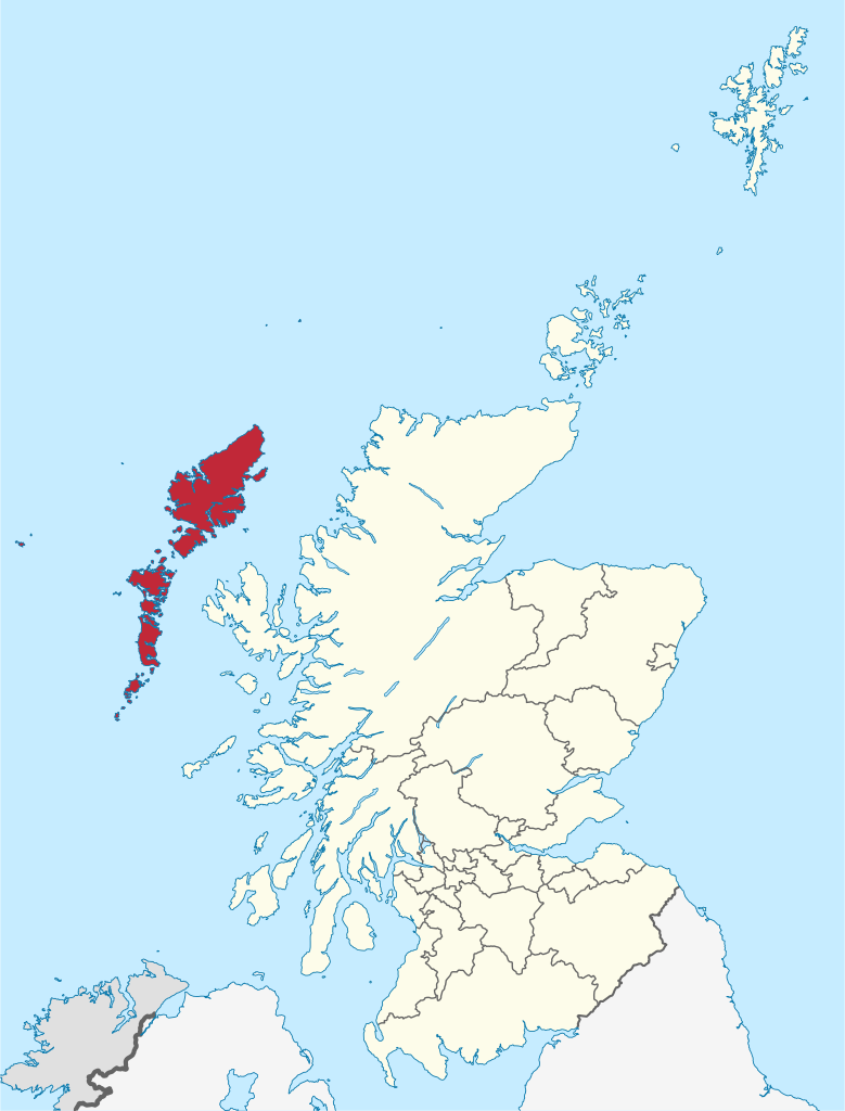
The Outer Hebrides (/ˈhɛbrɪdiːz/) or Western Isles (Scottish Gaelic: Na h-Eileanan Siar [nə ˈhelanən ˈʃiəɾ] or Na h-Eileanan an Iar [nə ˈhelanən əˈɲiəɾ] or Na h-Innse Gall ('islands of the strangers'); Scots: Waster Isles), sometimes known as the Long Isle/Long Island (Scottish Gaelic: An t-Eilean Fada), is an island chain off the west coast of mainland Scotland. The islands are geographically coextensive with Comhairle nan Eilean Siar, one of the 32 unitary council areas of Scotland. They form part of the archipelago of the Hebrides, separated from the Scottish mainland and from the Inner Hebrides by the waters of the Minch, the Little Minch, and the Sea of the Hebrides. Scottish Gaelic is the predominant spoken language, although in a few areas English speakers form a majority. (Source: Wikipedia.org, CC BY-SA)
North Ayrshire (Scottish Gaelic: Siorrachd Àir a Tuath, pronounced [ˈʃirˠəxk aːɾʲ ə t̪ʰuə]) is one of 32 council areas in Scotland. The council area borders Inverclyde to the north, Renfrewshire and East Renfrewshire to the northeast, and East Ayrshire and South Ayrshire to the east and south respectively. The local authority is North Ayrshire Council, formed in 1996 with the same boundaries as the district of Cunninghame which existed from 1975 to 1996. Located in the west central Lowlands with the Firth of Clyde to its west, the council area covers the northern portion of the historic county of Ayrshire, in addition to the islands of Arran and The Cumbraes from the historic county of Buteshire. North Ayrshire has a population of roughly 135,280 people. Its largest towns are Irvine and Kilwinning. (Source: Wikipedia.org, CC BY-SA)

Time for recess! Post a comment, ask a question or write a review. Feel free to let us know what you think!
Want even more practice? Visit similar websites offering realistic practice driving knowledge tests. Visit us to see what sets our tests apart! https://dkttest.com/capital-territory/
 0
0
Cool tool! And fun to check whether I remember the rules :) Two things I noticed: Warning for a crossroad side roads on the left and right. While technically that might be the correct translation, this sign tells you, that you are on the main road and have the right of way for the next crossroad and only the next crossroad. Usually (if no sign specifies otherwise) you have to give way to drivers coming from the right at every intersection, which can get a bit annoying in communal areas, so seeing this sign feels less like a warning and more like relief :). A Fahrradstraße is not a lane for cyclists but a street for cyclists, meaning the (whole!) street is intended predominantly for cyclists, who are then allowed to ride next to each other. Cars are allowed to drive there (unless another sign prohibits such), but have to adjust their speed to the cyclists. I believe they are not allowed to pass at all, even if the oncoming lane is empty.
-1
this website is a simpy website i love this its fat and im in my mums basement rn help sui u r a mothr fker
3
Hi i am such fat fan of this great gaming website. Im so hangry for the cause mate! Liking the simps eating on yall tho nott gonna lie to ya!
0
The system is now changed and they use some type of tablet for the exam now. Do anyone have the questions which they ask in the tablet because the questions are different. I still didn’t pass my provisional driving knowledge test. It would be great if someone could help
0
Good exercise !! Looking for some drift friends, hit to my email Funnyparts@gmail.com
The exercise of the activity of TVDE driver, without it being registered on an electronic platform, incurs:
0
Who will be responsible for infractions that may be committed and for damages caused to third parties, without prejudice to the corresponding administrative sanctions:
0
This answer is incorrect. What does this traffic sign mean? Square sign with a circular not parking inside. Choices: Begin of a zone where parking is allowed, Being of a zone with a speed limit, Begin of zone where parking is prohibited, Begin of a residential area. The correct answer should be Begin of a zone where parking is allowed NOT Begin of zone where parking is prohibited. It is a Controlled parking Zone.
0
Hi! Anyone please suggest me some personal driving tutors in Vantaa for few days.
0


More community