

Here you can study for the exam. Look up keywords and learn definitions about all kind of subjects.
More subjects
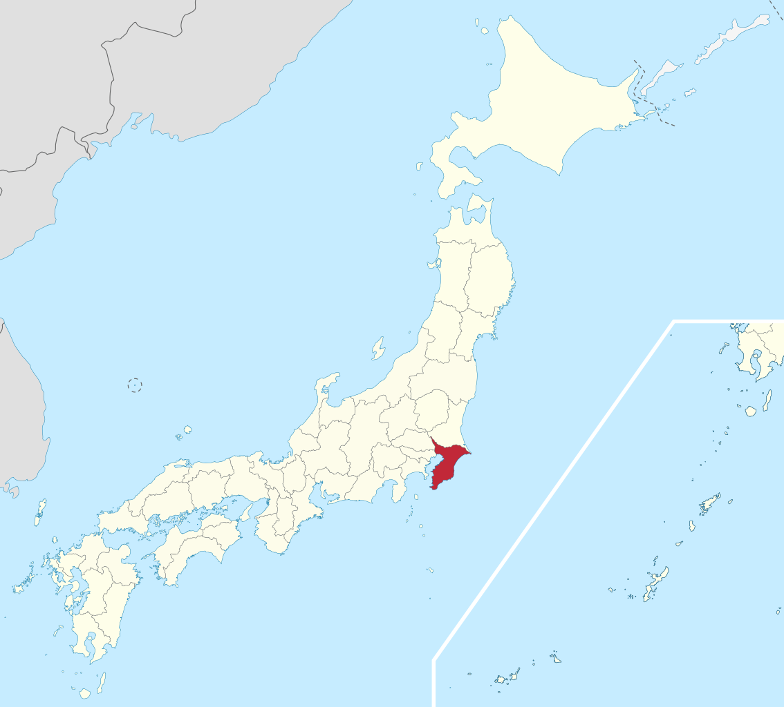
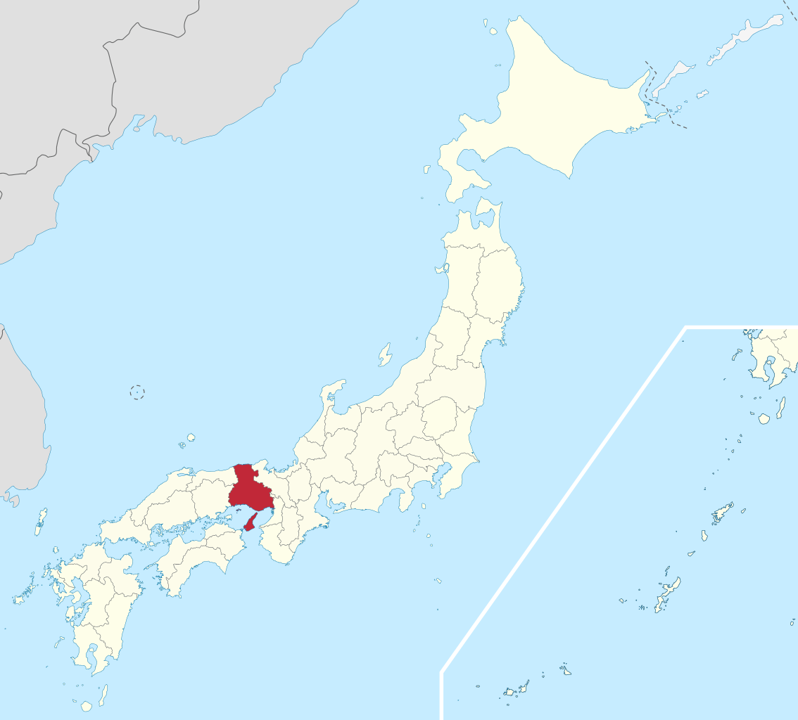
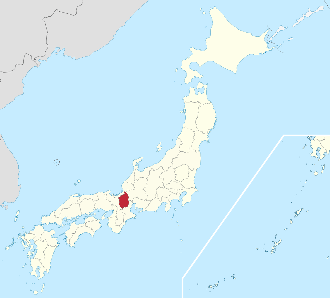
Aichi Prefecture (愛知県, Aichi-ken, Japanese pronunciation: [aitɕi̥ꜜkeɴ]) is a prefecture of Japan located in the Chūbu region of Honshū.: 11, 126 Aichi Prefecture has a population of 7,552,873 (as of 1 October 2019) and a geographic area of 5,172.92 square kilometres (1,997.28 sq mi) with a population density of 1,460 inhabitants per square kilometre (3,800/sq mi). Aichi Prefecture borders Mie Prefecture to the west, Gifu Prefecture and Nagano Prefecture to the north, and Shizuoka Prefecture to the east. (Source: Wikipedia.org, CC BY-SA)
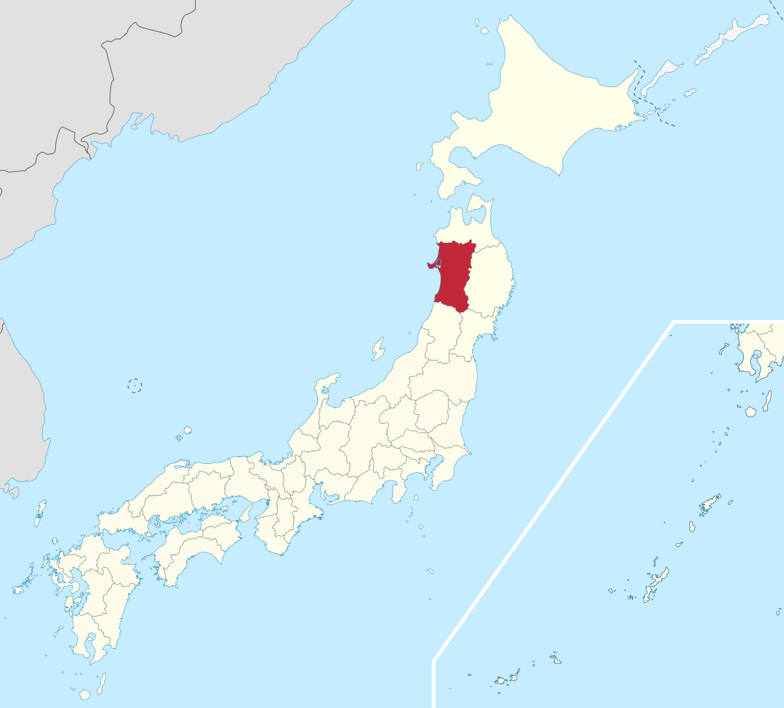
Akita Prefecture (秋田県, Akita-ken) [a̠kʲita̠] is a prefecture of Japan located in the Tōhoku region of Honshu. Its population is approximately 919,000 (as of 1 April 2023) and its geographic area is 11,637 km2 (4,493 sq mi). Akita Prefecture is bordered by Aomori Prefecture to the north, Iwate Prefecture to the east, Miyagi Prefecture to the southeast, and Yamagata Prefecture to the south. Akita is the capital and largest city of Akita Prefecture. Other major cities include Yokote, Daisen, and Yurihonjō. Akita Prefecture is located on the coast of the Sea of Japan and extends east to the Ōu Mountains, the longest mountain range in Japan, at the border with Iwate Prefecture. Akita Prefecture formed the northern half of the historic Dewa Province with Yamagata Prefecture. (Source: Wikipedia.org, CC BY-SA)
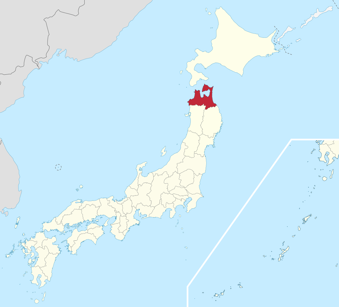
Aomori Prefecture (青森県, Aomori-ken) [a̠o̞mo̞ɾʲikẽ̞ɴ] is a prefecture of Japan in the Tōhoku region. The prefecture's capital, largest city, and namesake is the city of Aomori. Aomori is the northernmost prefecture on Japan's main island, Honshu, and is bordered by the Pacific Ocean to the east, Iwate Prefecture to the southeast, Akita Prefecture to the southwest, the Sea of Japan to the west, and Hokkaido across the Tsugaru Strait to the north. Aomori Prefecture is the 8th-largest prefecture, with an area of 9,645.64 km2 (3,724.20 sq mi), and the 31st-most populous prefecture, with more than 1.2 million people. Approximately 45 percent of Aomori Prefecture's residents live in its two core cities, Aomori and Hachinohe, which lie on coastal plains. The majority of the prefecture is covered in forested mountain ranges, with population centers occupying valleys and plains. Aomori is the third-most populous prefecture in the Tōhoku region, after Miyagi Prefecture and Fukushima Prefecture. Mount Iwaki, an active stratovolcano, is the prefecture's highest point, at almost 1,624.7 m (5,330 ft). (Source: Wikipedia.org, CC BY-SA)
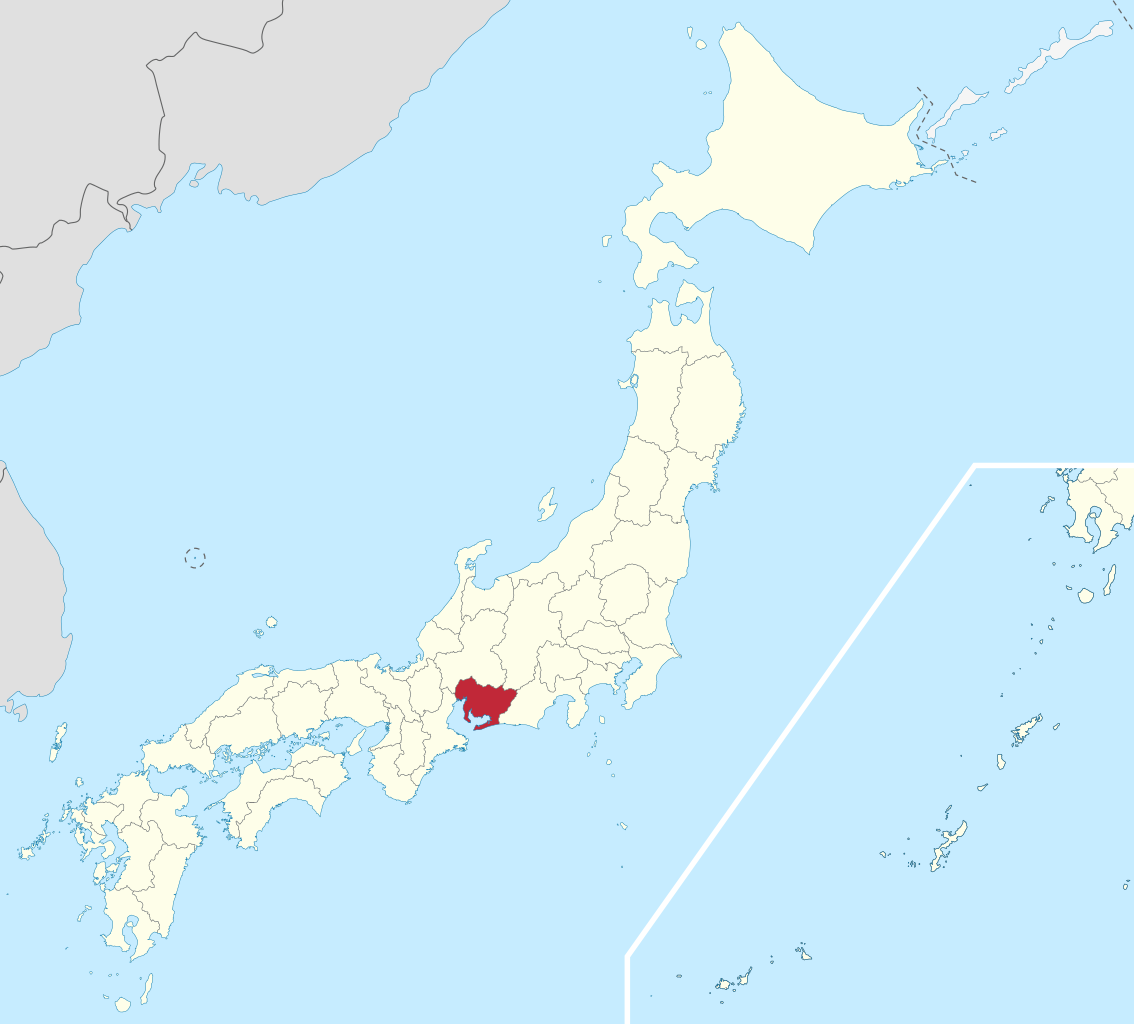
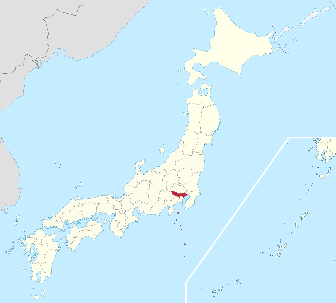
Chiba Prefecture (千葉県, Chiba-ken) is a prefecture of Japan located in the Kantō region of Honshu. Chiba Prefecture has a population of 6,278,060 (1 June 2019) and has a geographic area of 5,157 km2 (1,991 sq mi). Chiba Prefecture borders Ibaraki Prefecture to the north, Saitama Prefecture to the northwest, and Tokyo to the west. Chiba is the capital and largest city of Chiba Prefecture, with other major cities including Funabashi, Matsudo, Ichikawa and Kashiwa. Chiba Prefecture is located on Japan's eastern Pacific coast to the east of Tokyo, and is part of the Greater Tokyo Area, the most populous metropolitan area in the world. Chiba Prefecture largely consists of the Bōsō Peninsula, which encloses the eastern side of Tokyo Bay and separates it from Kanagawa Prefecture. Chiba Prefecture is home to Narita International Airport, the Tokyo Disney Resort, and the Keiyō Industrial Zone. (Source: Wikipedia.org, CC BY-SA)
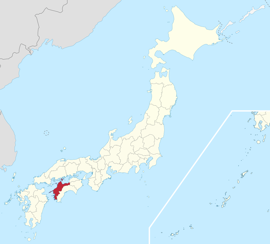
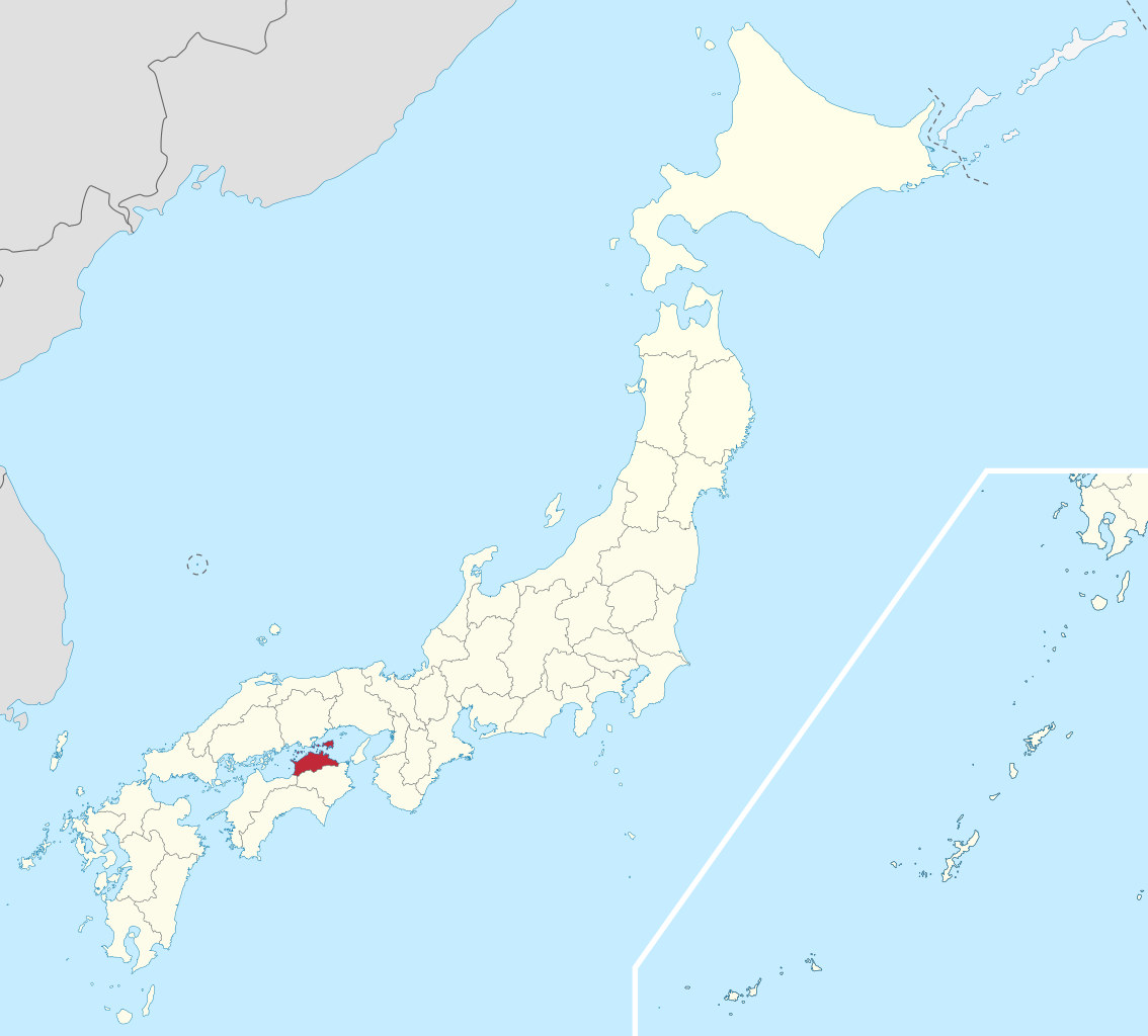
Ehime Prefecture (愛媛県, Ehime-ken) is a prefecture of Japan located on the island of Shikoku. Ehime Prefecture has a population of 1,342,011 (1 June 2019) and has a geographic area of 5,676 km2 (2,191 sq mi). Ehime Prefecture borders Kagawa Prefecture to the northeast, Tokushima Prefecture to the east, and Kōchi Prefecture to the southeast. Matsuyama is the capital and largest city of Ehime Prefecture and the largest city on Shikoku, with other major cities including Imabari, Niihama, and Saijō. Notable past Ehime residents include three Nobel Prize winners: they are Kenzaburo Oe (1994 Nobel Prize in Literature), Shuji Nakamura (2014 Nobel Prize in Physics), and Syukuro Manabe (2021 Nobel Prize in Physics). (Source: Wikipedia.org, CC BY-SA)
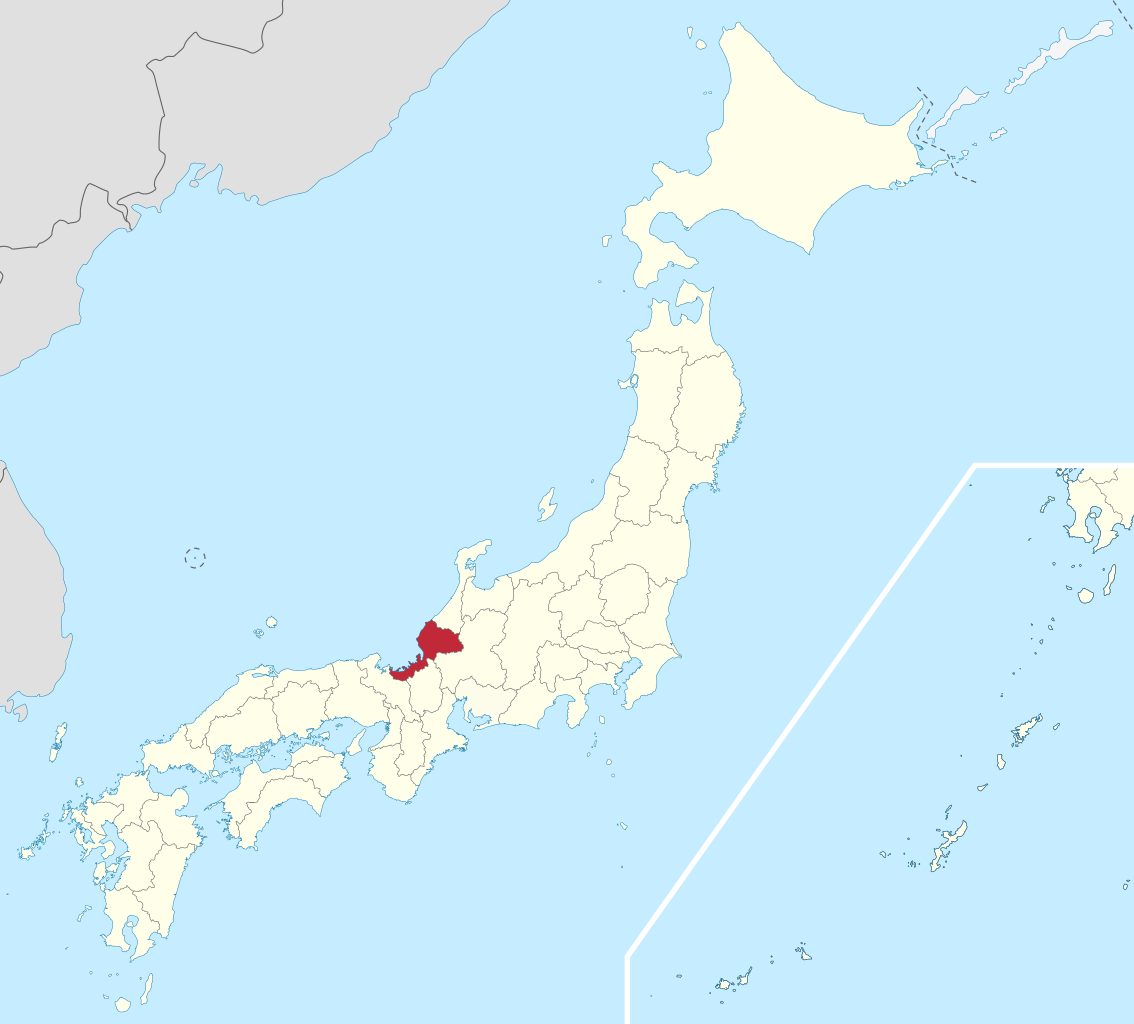
Fukui Prefecture (福井県, Fukui-ken) is a prefecture of Japan located in the Chūbu region of Honshū. Fukui Prefecture has a population of 778,943 (1 June 2017) and has a geographic area of 4,190 km2 (1,617 sq mi). Fukui Prefecture borders Ishikawa Prefecture to the north, Gifu Prefecture to the east, Shiga Prefecture to the south, and Kyoto Prefecture to the southwest. Fukui is the capital and largest city of Fukui Prefecture, with other major cities including Sakai, Echizen, and Sabae. Fukui Prefecture is located on the Sea of Japan coast and is part of the historic Hokuriku region of Japan. The Matsudaira clan, a powerful samurai clan during the Edo period that became a component of the Japanese nobility after the Meiji Restoration, was headquartered at Fukui Castle on the site of the modern prefectural offices. Fukui Prefecture is home to the Kitadani Formation, the Ichijōdani Asakura Family Historic Ruins, and the Tōjinbō cliff range. (Source: Wikipedia.org, CC BY-SA)
Fukuoka Prefecture (Japanese: 福岡県, Hepburn: Fukuoka-ken) is a prefecture of Japan located on the island of Kyūshū. Fukuoka Prefecture has a population of 5,109,323 (1 June 2019) and has a geographic area of 4,986 km2 (1,925 sq mi). Fukuoka Prefecture borders Saga Prefecture to the southwest, Kumamoto Prefecture to the south, and Ōita Prefecture to the southeast. Fukuoka is the capital and largest city of Fukuoka Prefecture, and the largest city on Kyūshū, with other major cities including Kitakyushu, Kurume, and Ōmuta. Fukuoka Prefecture is located at the northernmost point of Kyūshū on the Kanmon Straits, connecting the Tsushima Strait and the Seto Inland Sea across from Yamaguchi Prefecture on the island of Honshu, and extends south towards the Ariake Sea. (Source: Wikipedia.org, CC BY-SA)
Fukushima Prefecture (/ˌfuːkuːˈʃiːmə/; Japanese: 福島県, romanized: Fukushima-ken, pronounced [ɸɯ̥kɯɕimaꜜkeɴ]) is a prefecture of Japan located in the Tōhoku region of Honshu. Fukushima Prefecture has a population of 1,810,286 (as of 1 May 2021) and has a geographic area of 13,783 square kilometres (5,322 sq mi). Fukushima Prefecture borders Miyagi Prefecture and Yamagata Prefecture to the north, Niigata Prefecture to the west, Gunma Prefecture to the southwest, and Tochigi Prefecture and Ibaraki Prefecture to the south. Fukushima is the capital and Iwaki is the largest city of Fukushima Prefecture, with other major cities including Kōriyama, Aizuwakamatsu, and Sukagawa. Fukushima Prefecture is located on Japan's eastern Pacific coast at the southernmost part of the Tōhoku region, and is home to Lake Inawashiro, the fourth-largest lake in Japan. Fukushima Prefecture is the third-largest prefecture of Japan (after Hokkaido and Iwate Prefecture) and divided by mountain ranges into the three regions of Aizu, Nakadōri, and Hamadōri. (Source: Wikipedia.org, CC BY-SA)
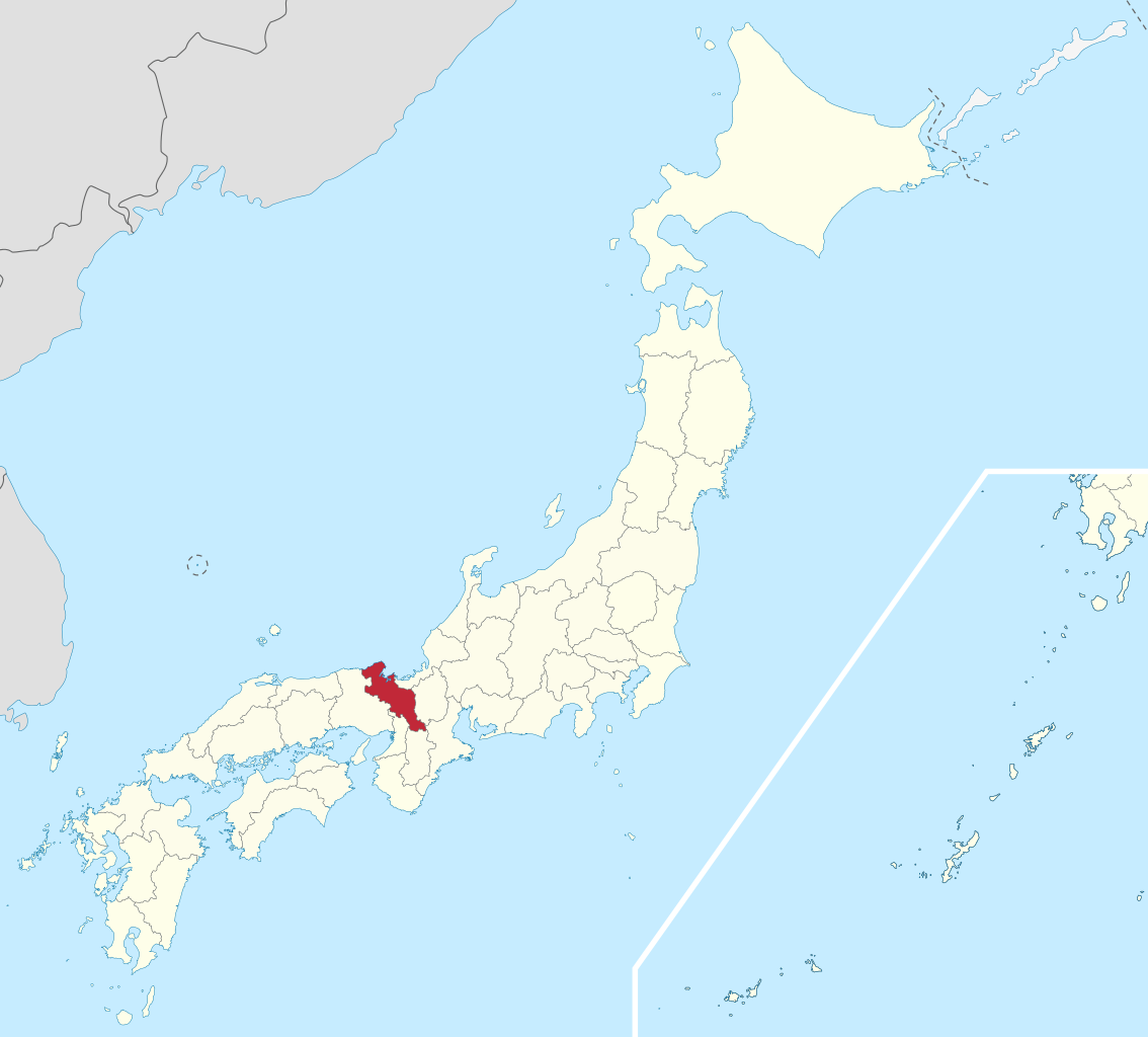
Gifu Prefecture (岐阜県, Gifu-ken) is a prefecture of Japan located in the Chūbu region of Honshu.: 246 : 126 Gifu Prefecture has a population of 1,991,390 (as of 1 June 2019) and has a geographic area of 10,621 square kilometres (4,101 sq mi). Gifu Prefecture borders Toyama Prefecture to the north; Ishikawa Prefecture to the northwest, Fukui Prefecture and Shiga Prefecture to the west, Mie Prefecture to the southwest, Aichi Prefecture to the south, and Nagano Prefecture to the east. Gifu is the capital and largest city of Gifu Prefecture, with other major cities including Ōgaki, Kakamigahara, and Tajimi.: 246 (Source: Wikipedia.org, CC BY-SA)
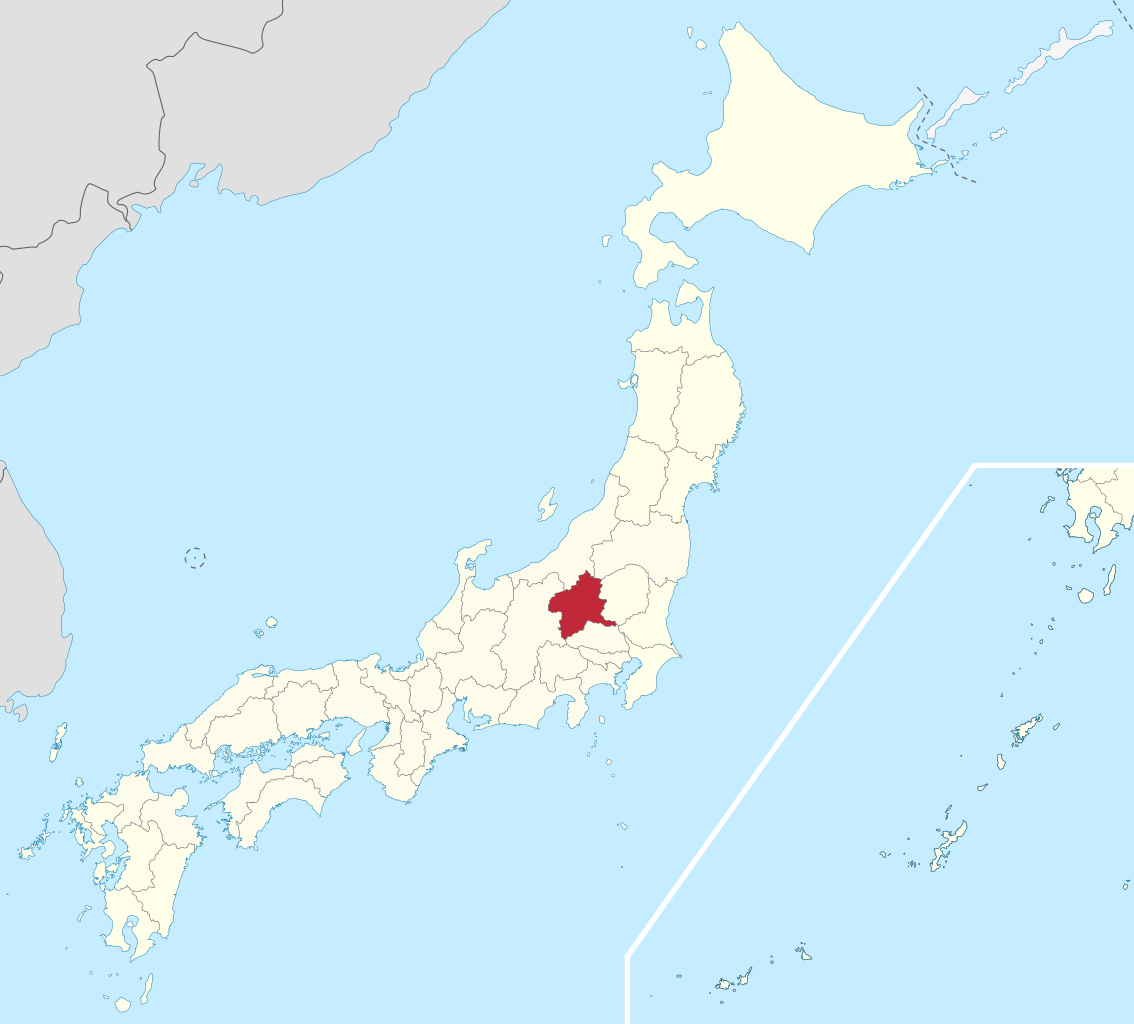
Gunma Prefecture (群馬県, Gunma-ken) is a prefecture of Japan located in the Kantō region of Honshu. Gunma Prefecture has a population of 1,937,626 (1 October 2019) and has a geographic area of 6,362 km2 (2,456 sq mi). Gunma Prefecture borders Niigata Prefecture and Fukushima Prefecture to the north, Nagano Prefecture to the southwest, Saitama Prefecture to the south, and Tochigi Prefecture to the east. Maebashi is the capital and Takasaki is the largest city of Gunma Prefecture, with other major cities including Ōta, Isesaki, and Kiryū. Gunma Prefecture is one of only eight landlocked prefectures, located on the northwestern corner of the Kantō Plain with 14% of its total land being designated as natural parks. (Source: Wikipedia.org, CC BY-SA)
Hiroshima Prefecture (広島県, Hiroshima-ken) is a prefecture of Japan located in the Chūgoku region of Honshu. Hiroshima Prefecture has a population of 2,811,410 (1 June 2019) and has a geographic area of 8,479 km² (3,274 sq mi). Hiroshima Prefecture borders Okayama Prefecture to the east, Tottori Prefecture to the northeast, Shimane Prefecture to the north, and Yamaguchi Prefecture to the southwest. Hiroshima is the capital and largest city of Hiroshima Prefecture, and the largest city in the Chūgoku region, with other major cities including Fukuyama, Kure, and Higashihiroshima. Hiroshima Prefecture is located on the Seto Inland Sea across from the island of Shikoku, and is bounded to the north by the Chūgoku Mountains. Hiroshima Prefecture is one of the three prefectures of Japan with more than one UNESCO World Heritage Site. (Source: Wikipedia.org, CC BY-SA)
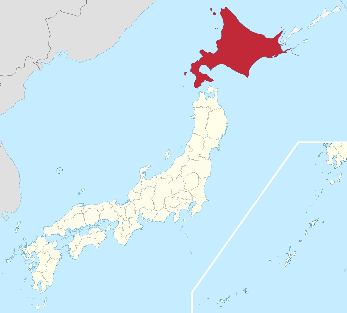
Hokkaido (Japanese: 北海道, Hepburn: Hokkaidō, pronounced [hokkaꜜidoː] ; lit. 'Northern Sea Circuit') is Japan's second largest island and comprises the largest and northernmost prefecture, making up its own region. The Tsugaru Strait separates Hokkaidō from Honshu; the two islands are connected by the undersea railway Seikan Tunnel. The largest city on Hokkaidō is its capital, Sapporo, which is also its only ordinance-designated city. Sakhalin lies about 43 kilometers (26 mi) to the north of Hokkaidō, and to the east and northeast are the Kuril Islands, which are administered by Russia, though the four most southerly are claimed by Japan. Hokkaidō was formerly known as Ezo, Yezo, Yeso, or Yesso. (Source: Wikipedia.org, CC BY-SA)
Hyōgo Prefecture (兵庫県, Hyōgo-ken) is a prefecture of Japan located in the Kansai region of Honshu. Hyōgo Prefecture has a population of 5,469,762 (as of 1 June 2019) and has a geographic area of 8,400 square kilometres (3,200 sq mi). Hyōgo Prefecture borders Kyoto Prefecture to the east, Osaka Prefecture to the southeast, and Okayama Prefecture and Tottori Prefecture to the west. Kōbe is the capital and largest city of Hyōgo Prefecture, and the seventh-largest city in Japan, with other major cities including Himeji, Nishinomiya, and Amagasaki. Hyōgo Prefecture's mainland stretches from the Sea of Japan to the Seto Inland Sea, where Awaji Island and a small archipelago of islands belonging to the prefecture are located. Hyōgo Prefecture is a major economic center, transportation hub, and tourist destination in western Japan, with 20% of the prefecture's land area designated as Natural Parks. Hyōgo Prefecture forms part of the Keihanshin metropolitan area, the second-most-populated urban region in Japan after the Greater Tokyo area and one of the world's most productive regions by GDP. (Source: Wikipedia.org, CC BY-SA)
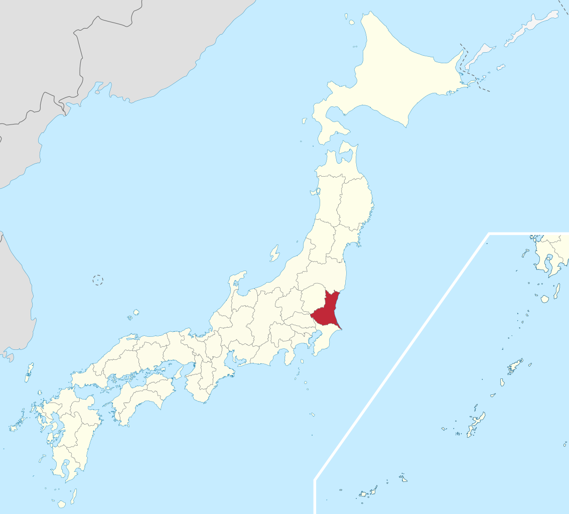
Ibaraki Prefecture (茨城県, Ibaraki-ken) is a prefecture of Japan located in the Kantō region of Honshu. Ibaraki Prefecture has a population of 2,871,199 (1 June 2019) and has a geographic area of 6,097.19 square kilometres (2,354.14 square miles). Ibaraki Prefecture borders Fukushima Prefecture to the north, Tochigi Prefecture to the northwest, Saitama Prefecture to the southwest, Chiba Prefecture to the south, and the Pacific Ocean to the east. Mito, the capital, is the largest city in Ibaraki Prefecture. Other major cities include Tsukuba, Hitachi, and Hitachinaka. Ibaraki Prefecture is located on Japan's eastern Pacific coast to the northeast of Tokyo, and is part of the Greater Tokyo Area, the most populous metropolitan area in the world. Ibaraki Prefecture features Lake Kasumigaura, the second-largest lake in Japan; the Tone River, Japan's second-longest river and largest drainage basin; and Mount Tsukuba, one of the most famous mountains in Japan. Ibaraki Prefecture is also home to Kairaku-en, one of the Three Great Gardens of Japan, and is an important center for the martial art of Aikido. (Source: Wikipedia.org, CC BY-SA)
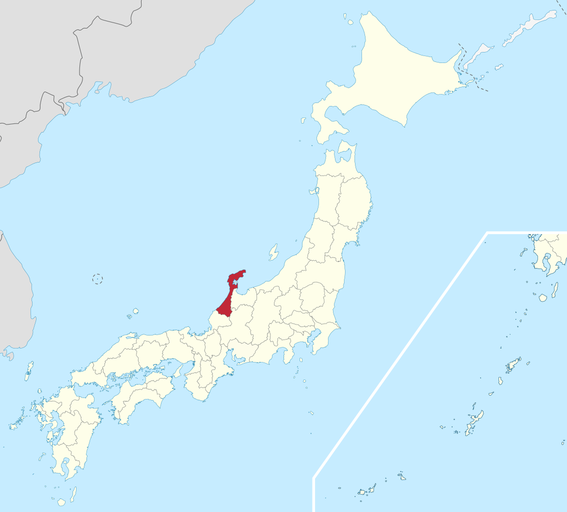
Ishikawa Prefecture (石川県, Ishikawa-ken) is a prefecture of Japan located in the Chūbu region of Honshu island. Ishikawa Prefecture has a population of 1,140,573 (31 October 2019) and has a geographic area of 4,186 km2 (1,616 sq mi). Ishikawa Prefecture borders Toyama Prefecture to the east, Gifu Prefecture to the southeast, and Fukui Prefecture to the south. Kanazawa is the capital and largest city of Ishikawa Prefecture, with other major cities including Hakusan, Komatsu, and Kaga. Ishikawa is located on the Sea of Japan coast and features the most of the Noto Peninsula which forms Toyama Bay, one of the largest bays in Japan. Ishikawa Prefecture is part of the historic Hokuriku region and formerly an important populated center that contained some of the wealthiest han (domains) of the Japanese feudal era. Ishikawa Prefecture is home to Kanazawa Castle, Kenroku-en one of the Three Great Gardens of Japan, Nyotaimori ('body sushi'), and Kutani ware. (Source: Wikipedia.org, CC BY-SA)
Iwate Prefecture (岩手県, Iwate-ken) is a prefecture of Japan located in the Tōhoku region of Honshu. It is the second-largest Japanese prefecture at 15,275 square kilometres (5,898 sq mi), with a population of 1,210,534 (as of October 1, 2020). Iwate Prefecture borders Aomori Prefecture to the north, Akita Prefecture to the west, and Miyagi Prefecture to the south. Morioka is the capital and largest city of Iwate Prefecture; other major cities include Ichinoseki, Ōshū, and Hanamaki. Located on Japan's Pacific Ocean coast, Iwate Prefecture features the easternmost point of Honshu at Cape Todo, and shares the highest peaks of the Ōu Mountains—the longest mountain range in Japan—at the border with Akita Prefecture. Iwate Prefecture is home to famous attractions such as Morioka Castle, the Buddhist temples of Hiraizumi including Chūson-ji and Mōtsū-ji, the Fujiwara no Sato movie lot and theme park in Ōshū, and the Tenshochi park in Kitakami known for its huge, ancient cherry trees. Iwate has the lowest population density of any prefecture outside Hokkaido, 5% of its total land area having been designated as National Parks. (Source: Wikipedia.org, CC BY-SA)
Kagawa Prefecture (香川県, Kagawa-ken) is a prefecture of Japan located on the island of Shikoku. Kagawa Prefecture has a population of 949,358 (as of 2020) and is the smallest prefecture by geographic area at 1,877 square kilometres (725 sq mi). Kagawa Prefecture borders Ehime Prefecture to the southwest and Tokushima Prefecture to the south. Takamatsu is the capital and largest city of Kagawa Prefecture, with other major cities including Marugame, Mitoyo, and Kan'onji. Kagawa Prefecture is located on the Seto Inland Sea across from Okayama Prefecture on the island of Honshu, which is connected by the Great Seto Bridge. Kagawa Prefecture includes Shōdoshima, the second-largest island in the Seto Inland Sea, and the prefecture's southern land border with Tokushima Prefecture is formed by the Sanuki Mountains. (Source: Wikipedia.org, CC BY-SA)
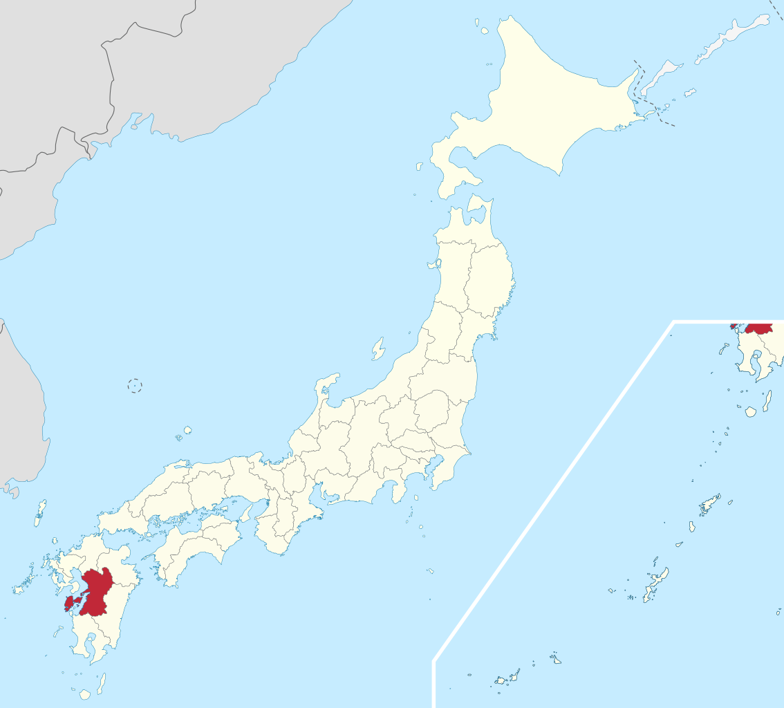
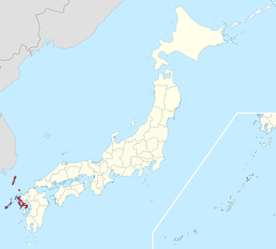
Kagoshima Prefecture (鹿児島県, Kagoshima-ken) is a prefecture of Japan located on the island of Kyushu and the Ryukyu Islands. Kagoshima Prefecture has a population of 1,599,779 (1 January 2020) and has a geographic area of 9,187 km2 (3,547 sq mi). Kagoshima Prefecture borders Kumamoto Prefecture to the north and Miyazaki Prefecture to the northeast. Kagoshima is the capital and largest city of Kagoshima Prefecture, with other major cities including Kirishima, Kanoya, and Satsumasendai. Kagoshima Prefecture is located at the southernmost point of Kyūshū and includes the Satsunan Islands group of the Ryukyu Islands. Kagoshima Prefecture's mainland territory extends from the Ariake Sea to Shibushi Bay on the Pacific Ocean coast, and is characterized by two large peninsulas created by Kagoshima Bay. Kagoshima Prefecture formed the core of the Satsuma Domain, ruled from Kagoshima Castle, one of the most important Japanese domains of the Edo period and the Meiji Restoration. (Source: Wikipedia.org, CC BY-SA)
Kanagawa Prefecture (神奈川県, Kanagawa-ken) is a prefecture of Japan located in the Kantō region of Honshu. Kanagawa Prefecture is the second-most populous prefecture of Japan at 9,221,129 (1 April 2022) and third-densest at 3,800 inhabitants per square kilometre (9,800/sq mi). Its geographic area of 2,415 km2 (932 sq mi) makes it fifth-smallest. Kanagawa Prefecture borders Tokyo to the north, Yamanashi Prefecture to the northwest and Shizuoka Prefecture to the west. (Source: Wikipedia.org, CC BY-SA)
Kumamoto Prefecture (熊本県, Kumamoto-ken) is a prefecture of Japan located on the island of Kyūshū. Kumamoto Prefecture has a population of 1,748,134 (as of 1 June 2019) and has a geographic area of 7,409 square kilometres (2,861 sq mi). Kumamoto Prefecture borders Fukuoka Prefecture to the north, Ōita Prefecture to the northeast, Miyazaki Prefecture to the southeast, and Kagoshima Prefecture to the south. Kumamoto is the capital and largest city of Kumamoto Prefecture, with other major cities including Yatsushiro, Amakusa, and Tamana. Kumamoto Prefecture is located in the center of Kyūshū on the coast of the Ariake Sea, across from Nagasaki Prefecture, with the mainland separated from the East China Sea by the Amakusa Archipelago. Kumamoto Prefecture is home to Mount Aso, the largest active volcano in Japan and among the largest in the world, with its peak 1,592 metres (5,223 ft) above sea level. (Source: Wikipedia.org, CC BY-SA)
Kyoto Prefecture (京都府, Kyōto-fu) is a prefecture of Japan located in the Kansai region of Honshu.: 477, 587 Kyoto Prefecture has a population of 2,561,358 (as of October 2021) and has a geographic area of 4,612 square kilometres (1,781 sq mi). Kyoto Prefecture borders Fukui Prefecture to the northeast, Shiga Prefecture to the east, Mie Prefecture to the southeast, Nara Prefecture and Osaka Prefecture to the south, and Hyōgo Prefecture to the west. (Source: Wikipedia.org, CC BY-SA)
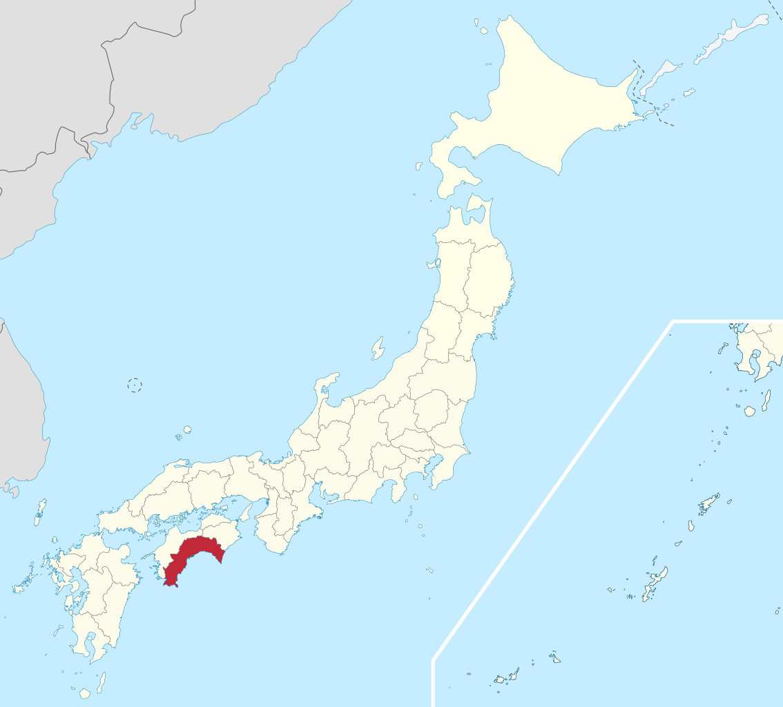
Kōchi Prefecture (高知県, Kōchi-ken, pronounced [koːtɕi ꜜkeɴ]; /ˈkoʊtʃi/) is a prefecture of Japan located on the island of Shikoku. Kōchi Prefecture has a population of 757,914 (1 December 2011) and has a geographic area of 7,103 km2 (2,742 sq mi). Kōchi Prefecture borders Ehime Prefecture to the northwest and Tokushima Prefecture to the northeast. Kōchi is the capital and largest city of Kōchi Prefecture, with other major cities including Nankoku, Shimanto, and Kōnan. Kōchi Prefecture is located on Japan's Pacific coast surrounding a large bay in the south of Shikoku, with the southernmost point of the island located at Cape Ashizuri in Tosashimizu. Kōchi Prefecture is home to Kōchi Castle, considered the most intact Japanese castle, and the Shimanto River, one of the few undammed rivers in Japan. (Source: Wikipedia.org, CC BY-SA)
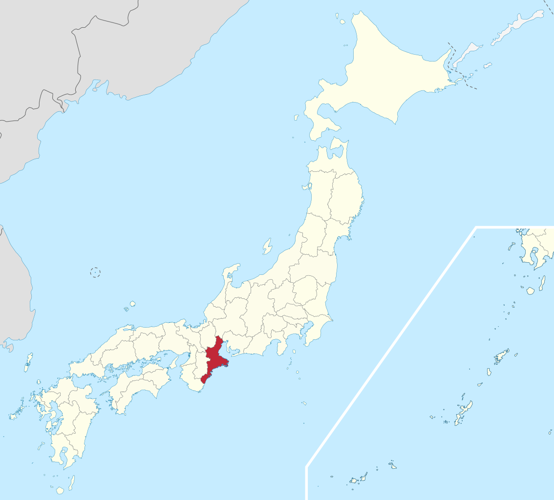
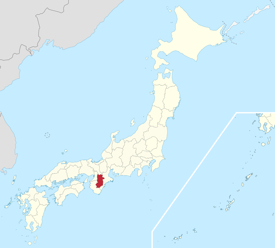
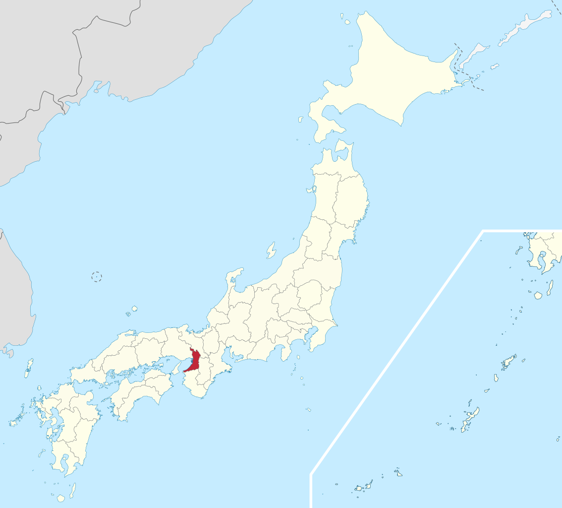
Mie Prefecture (三重県, Mie-ken) is a prefecture of Japan located in the Kansai region of Honshu. Mie Prefecture has a population of 1,781,948 (as of 1 June 2019) and has a geographic area of 5,774 square kilometers (2,229 sq mi). Mie Prefecture is bordered by Gifu Prefecture to the north, Shiga Prefecture and Kyoto Prefecture to the northwest, Nara Prefecture to the west, Wakayama Prefecture to the southwest, and Aichi Prefecture to the east. Tsu is the capital and Yokkaichi is the largest city of Mie Prefecture, with other major cities including Suzuka, Matsusaka, Ise, and Kuwana.: 995 Mie Prefecture is located on the eastern coast of the Kii Peninsula, forming the western side of Ise Bay which features the mouths of the Kiso Three Rivers. Mie Prefecture is a popular tourism destination home to Nagashima Spa Land, Suzuka International Racing Course, and some of the oldest and holiest sites in Shinto, the traditional religion of Japan, including the Ise Grand Shrine and the Tsubaki Grand Shrine. (Source: Wikipedia.org, CC BY-SA)
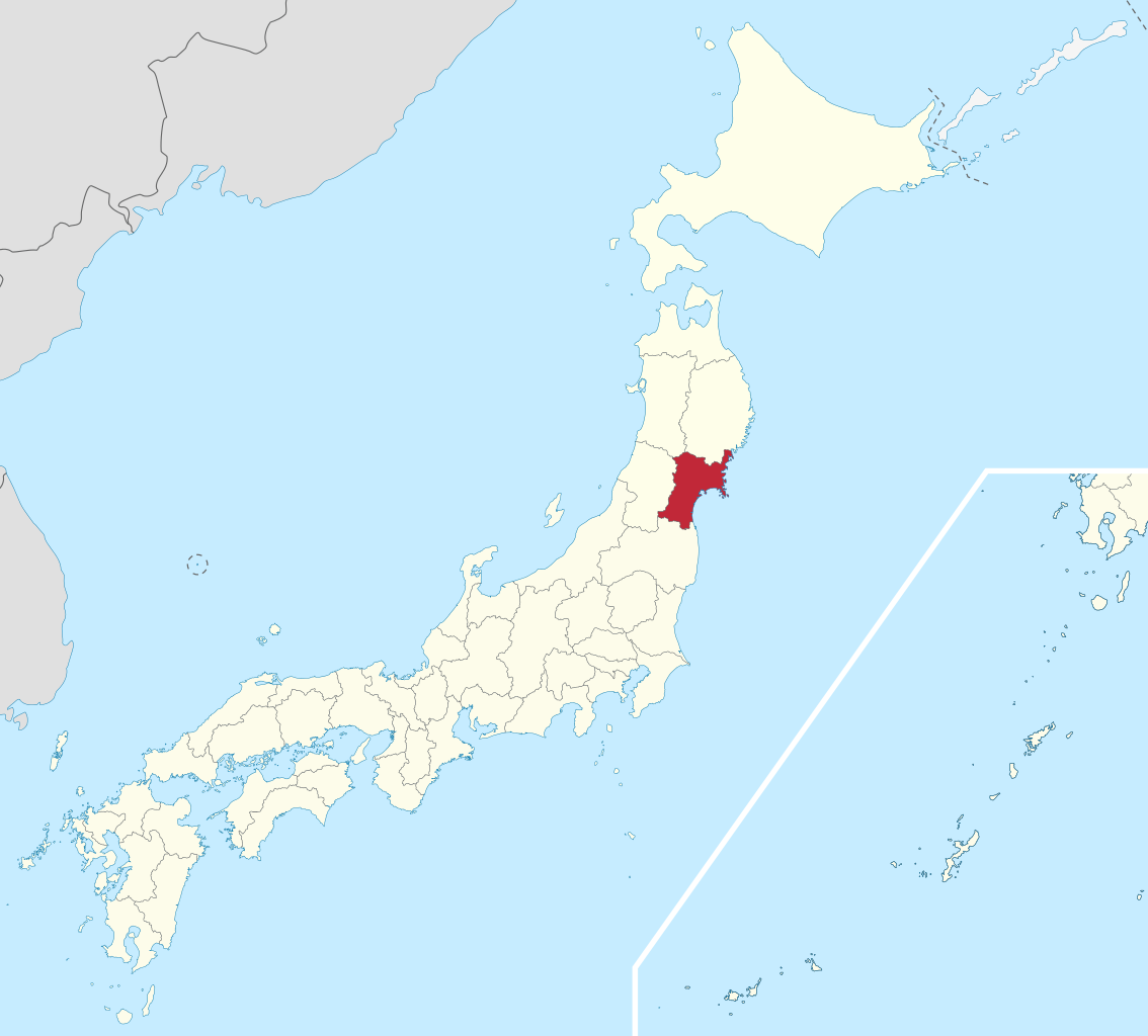
Miyagi Prefecture (宮城県, Miyagi-ken) is a prefecture of Japan located in the Tōhoku region of Honshu. Miyagi Prefecture has a population of 2,305,596 (1 June 2019) and has a geographic area of 7,282 km2 (2,812 sq mi). Miyagi Prefecture borders Iwate Prefecture to the north, Akita Prefecture to the northwest, Yamagata Prefecture to the west, and Fukushima Prefecture to the south. Sendai is the capital and largest city of Miyagi Prefecture, and the largest city in the Tōhoku region, with other major cities including Ishinomaki, Ōsaki, and Tome. Miyagi Prefecture is located on Japan's eastern Pacific coast and bounded to the west by the Ōu Mountains, the longest mountain range in Japan, with 24% of its total land area being designated as Natural Parks. Miyagi Prefecture is home to Matsushima Islands, a group of islands ranked as one of the Three Views of Japan, near the town of Matsushima. (Source: Wikipedia.org, CC BY-SA)
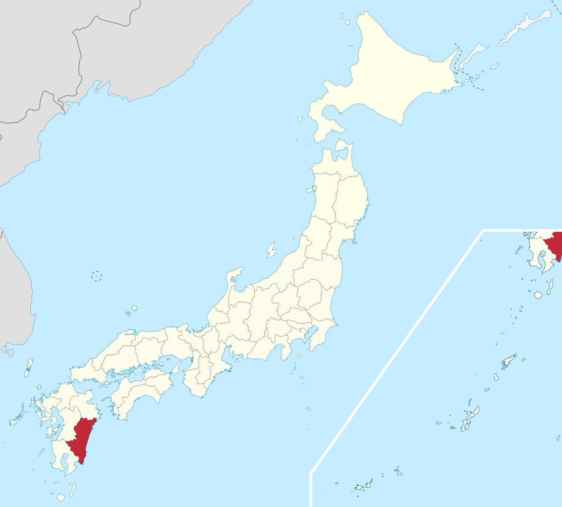
Miyazaki Prefecture (宮崎県, Miyazaki-ken) is a prefecture of Japan located on the island of Kyūshū. Miyazaki Prefecture has a population of 1,073,054 (1 June 2019) and has a geographic area of 7,735 km2 (2,986 sq mi). Miyazaki Prefecture borders Ōita Prefecture to the north, Kumamoto Prefecture to the northwest, and Kagoshima Prefecture to the southwest. Miyazaki is the capital and largest city of Miyazaki Prefecture, with other major cities including Miyakonojō, Nobeoka, and Hyūga. Miyazaki Prefecture is located in southeastern Kyūshū on Japan's Pacific coast, with its coastline extending from Nobeoka near the entrance to the Bungo Channel to Shibushi Bay in Kushima. (Source: Wikipedia.org, CC BY-SA)
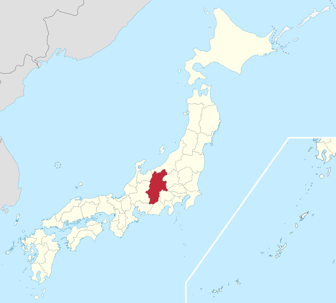
Nagano Prefecture (長野県, Nagano-ken) is a landlocked prefecture of Japan located in the Chūbu region of Honshū. Nagano Prefecture has a population of 2,052,493 (as of 1 June 2019) and has a geographic area of 13,561 square kilometres (5,236 sq mi). Nagano Prefecture borders Niigata Prefecture to the north, Gunma Prefecture to the northeast, Saitama Prefecture to the east, Yamanashi Prefecture to the southeast, Shizuoka Prefecture and Aichi Prefecture to the south, and Gifu Prefecture and Toyama Prefecture to the west. (Source: Wikipedia.org, CC BY-SA)
Nagasaki Prefecture (長崎県, Nagasaki-ken) is a prefecture of Japan located on the island of Kyūshū. Nagasaki Prefecture has a population of 1,314,078 (1 June 2020) and has a geographic area of 4,130 km2 (1,594 sq mi). Nagasaki Prefecture borders Saga Prefecture to the northeast. Nagasaki is the capital and largest city of Nagasaki Prefecture, with other major cities including Sasebo, Isahaya, and Ōmura. Nagasaki Prefecture is located in western Kyūshū with a territory consisting of many mainland peninsulas centered around Ōmura Bay, as well as islands and archipelagos including Tsushima and Iki in the Korea Strait and the Gotō Islands in the East China Sea. Nagasaki Prefecture is known for its century-long trading history with the Europeans and as the sole place of direct trade and exchange between Japan and the outside world during the Sakoku period. Nagasaki Prefecture is home to several of the Hidden Christian Sites in the Nagasaki Region which have been declared a UNESCO World Heritage Site. (Source: Wikipedia.org, CC BY-SA)
Nara Prefecture (奈良県, Nara-ken) is a prefecture of Japan located in the Kansai region of Honshu. As of 2020, Nara Prefecture has a population of 1,321,805 and has a geographic area of 3,691 square kilometres (1,425 sq mi). Nara Prefecture borders Kyoto Prefecture to the north, Osaka Prefecture to the northwest, Wakayama Prefecture to the southwest, and Mie Prefecture to the east. Nara is the capital and largest city of Nara Prefecture, with other major cities including Kashihara, Ikoma, and Yamatokōriyama. Nara Prefecture is located in the center of the Kii Peninsula on Japan's Pacific Ocean coast, and is one of only eight landlocked prefectures. Nara Prefecture has the distinction of having more UNESCO World Heritage listings than any other prefecture in Japan. (Source: Wikipedia.org, CC BY-SA)
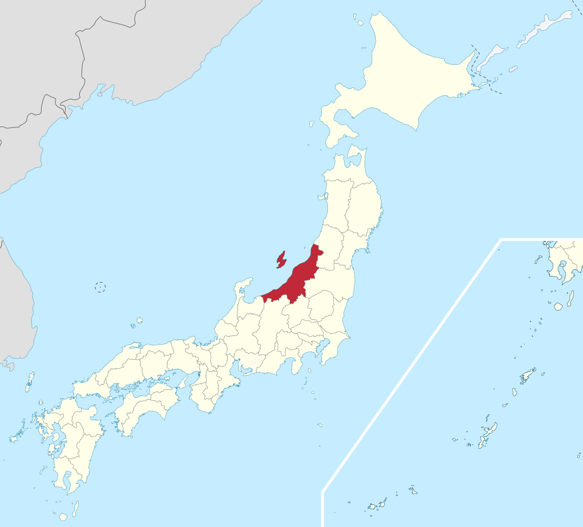
Niigata Prefecture (新潟県, Niigata-ken) is a prefecture in the Chūbu region of Honshu of Japan. Niigata Prefecture has a population of 2,227,496 (1 July 2019) and is the fifth-largest prefecture of Japan by geographic area at 12,584.18 km2 (4,858.78 sq mi). Niigata Prefecture borders Toyama Prefecture and Nagano Prefecture to the southwest, Gunma Prefecture to the south, Fukushima Prefecture to the east, and Yamagata Prefecture to the northeast. Niigata is the capital and largest city of Niigata Prefecture, with other major cities including Nagaoka, Jōetsu, and Sanjō. Niigata Prefecture contains the Niigata Major Metropolitan Area centered on Niigata with a population of 1,395,612, the largest metropolitan area on the Sea of Japan coast and the twelfth-largest in Japan. Niigata Prefecture is part of the historic Hokuriku region and features Sado Island, the sixth largest island of Japan in area following the four main islands and Okinawa Island. (Source: Wikipedia.org, CC BY-SA)
Okayama Prefecture (岡山県, Okayama-ken) is a prefecture of Japan located in the Chūgoku region of Honshu. Okayama Prefecture has a population of 1,906,464 (1 February 2018) and has a geographic area of 7,114 km2 (2,746 sq mi). Okayama Prefecture borders Tottori Prefecture to the north, Hyōgo Prefecture to the east, and Hiroshima Prefecture to the west. Okayama is the capital and largest city of Okayama Prefecture, with other major cities including Kurashiki, Tsuyama, and Sōja. Okayama Prefecture's south is located on the Seto Inland Sea coast across from Kagawa Prefecture on the island of Shikoku, which are connected by the Great Seto Bridge, while the north is characterized by the Chūgoku Mountains. (Source: Wikipedia.org, CC BY-SA)
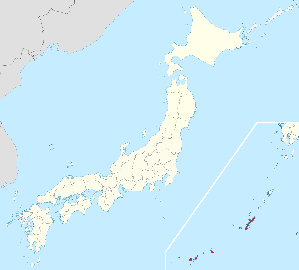
Okinawa Prefecture (沖縄県, Japanese: Okinawa-ken) is a prefecture of Japan. Okinawa Prefecture is the southernmost and westernmost prefecture of Japan and has a population of 1,457,162 (as of 2 February 2020) and a geographic area of 2,281 km2 (880 sq mi). Naha is the capital and largest city, with other major cities including Okinawa, Uruma, and Urasoe. Okinawa Prefecture encompasses two thirds of the Ryukyu Islands, including the Okinawa, Daitō and Sakishima groups, extending 1,000 kilometres (620 mi) southwest from the Satsunan Islands of Kagoshima Prefecture to Taiwan (Hualien and Yilan Counties). Okinawa Prefecture's largest island, Okinawa Island, is the home to a majority of Okinawa's population. Okinawa's indigenous ethnic group are the Ryukyuan people, who also live in the Amami Islands of Kagoshima Prefecture. (Source: Wikipedia.org, CC BY-SA)
Osaka Prefecture (大阪府, Ōsaka-fu, pronounced [oːsaka ɸɯ]) is a prefecture of Japan located in the Kansai region of Honshu. Osaka Prefecture has a population of 8,778,035 (as of 1 April 2022) and has a geographic area of 1,905 square kilometres (736 sq mi). Osaka Prefecture borders Hyōgo Prefecture to the northwest, Kyoto Prefecture to the north, Nara Prefecture to the southeast, and Wakayama Prefecture to the south. Osaka is the capital and largest city of Osaka Prefecture, and the third-largest city in Japan, with other major cities including Sakai, Higashiōsaka, and Hirakata. Osaka Prefecture is the third-most-populous prefecture, but by geographic area the second-smallest; at 4,600 inhabitants per square kilometre (12,000/sq mi) it is the second-most densely populated, below only Tokyo. (Source: Wikipedia.org, CC BY-SA)
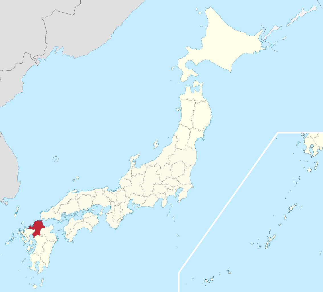
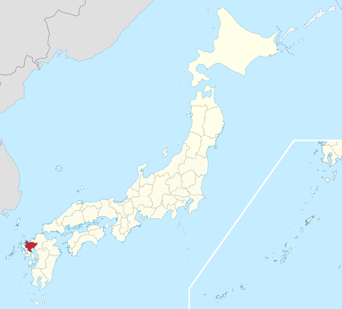
Saga Prefecture (佐賀県, Saga-ken) is a prefecture of Japan located on the island of Kyushu. Saga Prefecture has a population of 809,248 (1 August 2020) and has a geographic area of 2,440 km2 (942 sq mi). Saga Prefecture borders Fukuoka Prefecture to the northeast and Nagasaki Prefecture to the southwest. Saga is the capital and largest city of Saga Prefecture, with other major cities including Karatsu, Tosu, and Imari. Saga Prefecture is located in the northwest of Kyūshū covering an isthmus-like area extending between the Sea of Japan and the Ariake Sea. Saga Prefecture's western region is known for the production of ceramics and porcelain, particularly in the towns of Karatsu, Imari, and Arita. (Source: Wikipedia.org, CC BY-SA)
Saitama Prefecture (埼玉県, Saitama-ken) is a landlocked prefecture of Japan located in the Kantō region of Honshu. Saitama Prefecture has a population of 7,338,536 (1 January 2020) and has a geographic area of 3,797 km2 (1,466 sq mi). Saitama Prefecture borders Tochigi Prefecture and Gunma Prefecture to the north, Nagano Prefecture to the west, Yamanashi Prefecture to the southwest, Tokyo to the south, Chiba Prefecture to the southeast, and Ibaraki Prefecture to the northeast. Saitama is the capital and largest city of Saitama Prefecture, with other major cities including Kawaguchi, Kawagoe, and Tokorozawa. Saitama Prefecture is part of the Greater Tokyo Area, the most populous metropolitan area in the world, and many of its cities are described as bedroom communities and suburbs of Tokyo with many residents commuting into the city each day. (Source: Wikipedia.org, CC BY-SA)
Shiga Prefecture (滋賀県, Shiga-ken) is a landlocked prefecture of Japan located in the Kansai region of Honshu. Shiga Prefecture has a population of 1,412,916 (1 October 2015) and has a geographic area of 4,017 km2 (1,551 sq mi). Shiga Prefecture borders Fukui Prefecture to the north, Gifu Prefecture to the northeast, Mie Prefecture to the southeast, and Kyoto Prefecture to the west. Ōtsu is the capital and largest city of Shiga Prefecture, with other major cities including Kusatsu, Nagahama, and Higashiōmi. Shiga Prefecture encircles Lake Biwa, the largest freshwater lake in Japan, and 37% of the total land area is designated as Natural Parks, the highest of any prefecture. Shiga Prefecture's southern half is located adjacent to the former capital city of Kyoto and forms part of Greater Kyoto, the fourth-largest metropolitan area in Japan. Shiga Prefecture is home to Ōmi beef, the Eight Views of Ōmi, and Hikone Castle, one of four national treasure castles in Japan. (Source: Wikipedia.org, CC BY-SA)
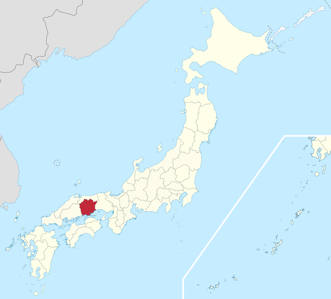
Shimane Prefecture (島根県, Shimane-ken) is a prefecture of Japan located in the Chūgoku region of Honshu. Shimane Prefecture is the second-least populous prefecture of Japan at 665,205 (February 1, 2021) and has a geographic area of 6,708.26 km2. Shimane Prefecture borders Yamaguchi Prefecture to the southwest, Hiroshima Prefecture to the south, and Tottori Prefecture to the east. Matsue is the capital and largest city of Shimane Prefecture, with other major cities including Izumo, Hamada, and Masuda. Shimane Prefecture contains the majority of the Lake Shinji-Nakaumi metropolitan area centered on Matsue, and with a population of approximately 600,000 is Japan's third-largest metropolitan area on the Sea of Japan coast after Niigata and Greater Kanazawa. (Source: Wikipedia.org, CC BY-SA)
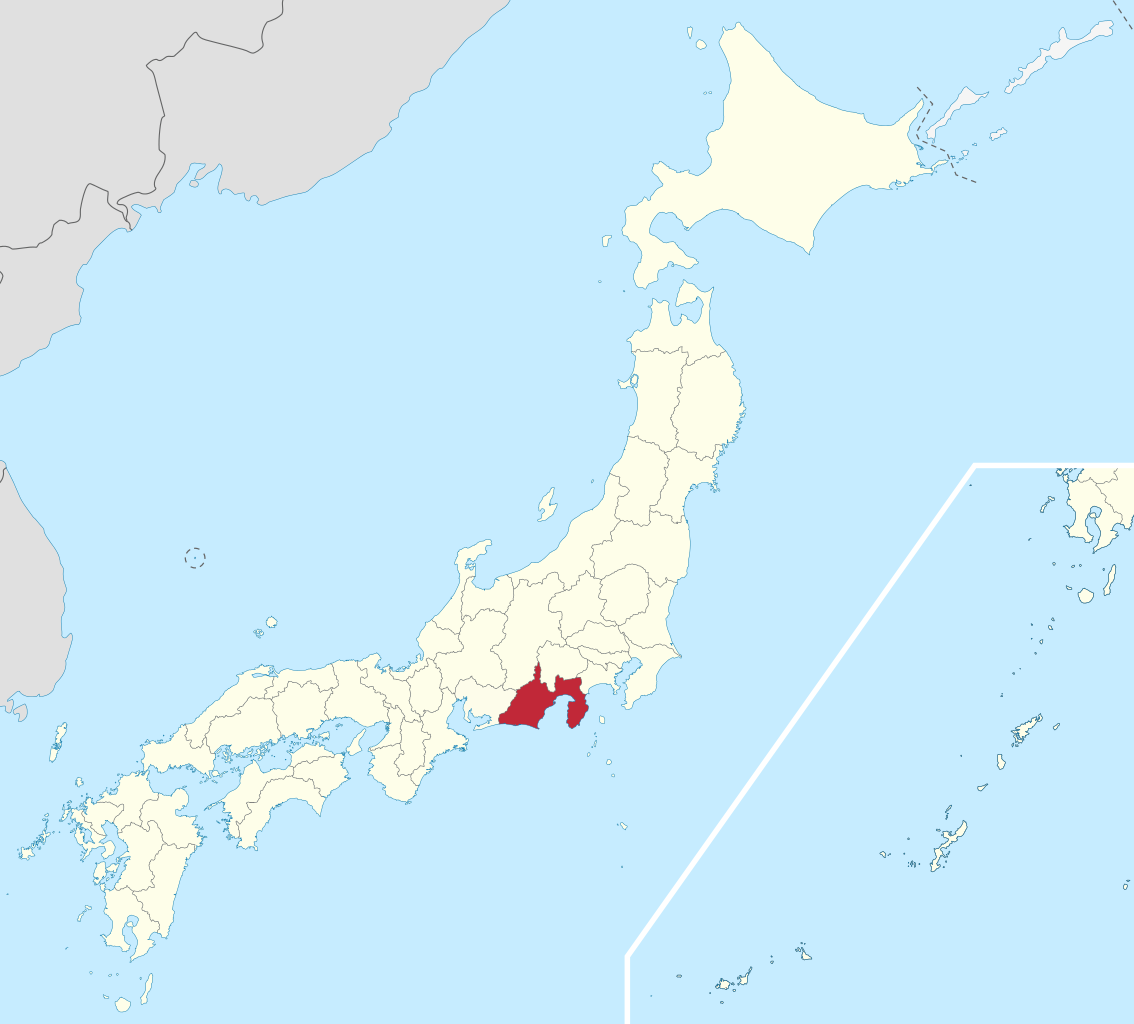
Shizuoka Prefecture (静岡県, Shizuoka-ken) is a prefecture of Japan located in the Chūbu region of Honshu. As of December 2019, Shizuoka Prefecture has a population of 3,637,998 and has a geographic area of 7,777.42 km2 (3,002.88 sq mi). Shizuoka Prefecture borders Kanagawa Prefecture to the east, Yamanashi Prefecture to the northeast, Nagano Prefecture to the north, and Aichi Prefecture to the west. Shizuoka is the capital and Hamamatsu is the largest city in Shizuoka Prefecture, with other major cities including Fuji, Numazu, and Iwata. Shizuoka Prefecture is located on Japan's Pacific Ocean coast and features Suruga Bay formed by the Izu Peninsula, and Lake Hamana which is considered to be one of Japan's largest lakes. Mount Fuji, the tallest volcano in Japan and cultural icon of the country, is partially located in Shizuoka Prefecture on the border with Yamanashi Prefecture. Shizuoka Prefecture has a significant motoring heritage as the founding location of Honda, Suzuki, and Yamaha, and is home to the Fuji International Speedway. (Source: Wikipedia.org, CC BY-SA)
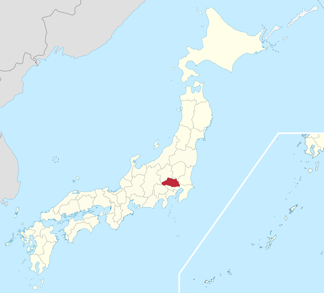
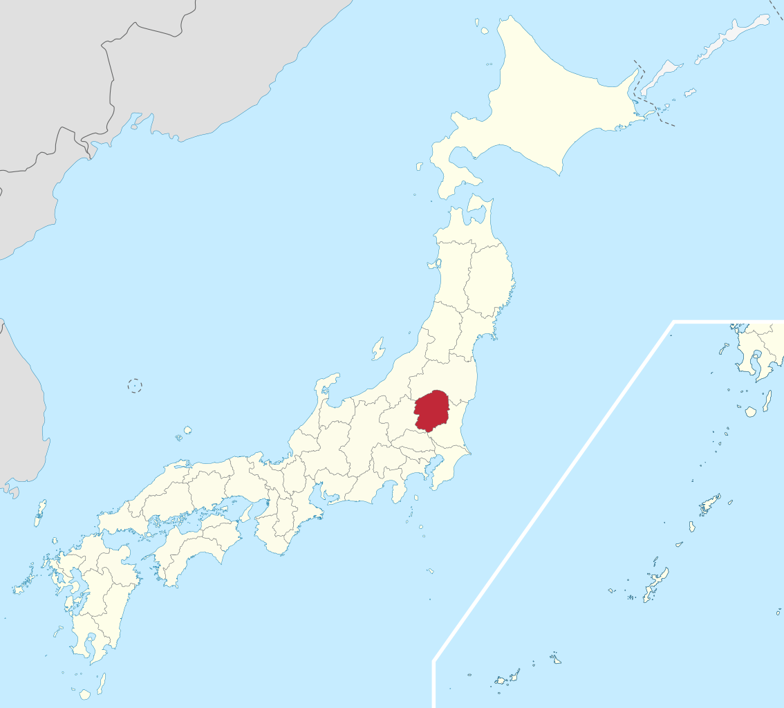
Tochigi Prefecture (栃木県, Tochigi-ken) is a prefecture of Japan located in the Kantō region of Honshu. Tochigi Prefecture has a population of 1,897,649 (1 June 2023) and has a geographic area of 6,408 km² (2,474 sq mi). Tochigi Prefecture borders Fukushima Prefecture to the north, Gunma Prefecture to the west, Saitama Prefecture to the south, and Ibaraki Prefecture to the southeast. Utsunomiya is the capital and largest city of Tochigi Prefecture, with other major cities including Oyama, Tochigi, and Ashikaga. Tochigi Prefecture is one of only eight landlocked prefectures and its mountainous northern region is a popular tourist region in Japan. The Nasu area is known for its onsens, local sake, and ski resorts, the villa of the Imperial Family, and the Nasushiobara station of the Shinkansen railway line. The city of Nikkō, with its ancient Shintō shrines and Buddhist temples, is a UNESCO World Heritage Site. (Source: Wikipedia.org, CC BY-SA)
Tokushima Prefecture (徳島県, Tokushima-ken) is a prefecture of Japan located on the island of Shikoku. Tokushima Prefecture has a population of 728,633 (1 October 2019) and has a geographic area of 4,146 km2 (1,601 sq mi). Tokushima Prefecture borders Kagawa Prefecture to the north, Ehime Prefecture to the west, and Kōchi Prefecture to the southwest. Tokushima is the capital and largest city of Tokushima Prefecture, with other major cities including Anan, Naruto, and Yoshinogawa. Tokushima Prefecture is located on the Kii Channel, connecting the Pacific Ocean and Seto Inland Sea, across from Wakayama Prefecture on the Kii Peninsula of the island of Honshu. Tokushima Prefecture is connected to Awaji Island across the Naruto Strait by the Ōnaruto Bridge as part of the Kobe-Awaji-Naruto Expressway, connecting the prefecture to the city of Kobe and the San'yō Expressway on Honshu. (Source: Wikipedia.org, CC BY-SA)
Tokyo (/ˈtoʊkioʊ/; Japanese: 東京, Tōkyō, [toːkʲoː] ), officially the Tokyo Metropolis (東京都, Tōkyō-to), is the capital and most populous city of Japan. Formerly known as Edo, its metropolitan area (including neighboring prefectures, 13,452 square kilometers or 5,194 square miles) is the most populous in the world, with an estimated 37.468 million residents as of 2018; although this number has been gradually decreasing since then, the prefecture itself has a population of 13.99 million people while the city's central 23 special wards have a population of 9.73 million. Located at the head of Tokyo Bay, the prefecture forms part of the Kantō region on the central coast of Honshu, Japan's largest island. Tokyo serves as Japan's economic center and is the seat of both the Japanese government and the Emperor of Japan. (Source: Wikipedia.org, CC BY-SA)

Time for recess! Post a comment, ask a question or write a review. Feel free to let us know what you think!
this website is a simpy website i love this its fat and im in my mums basement rn help sui u r a mothr fker
 2
2
Hi i am such fat fan of this great gaming website. Im so hangry for the cause mate! Liking the simps eating on yall tho nott gonna lie to ya!
0
The system is now changed and they use some type of tablet for the exam now. Do anyone have the questions which they ask in the tablet because the questions are different. I still didn’t pass my provisional driving knowledge test. It would be great if someone could help
0
Good exercise !! Looking for some drift friends, hit to my email Funnyparts@gmail.com
The exercise of the activity of TVDE driver, without it being registered on an electronic platform, incurs:
0
Who will be responsible for infractions that may be committed and for damages caused to third parties, without prejudice to the corresponding administrative sanctions:
0
This answer is incorrect. What does this traffic sign mean? Square sign with a circular not parking inside. Choices: Begin of a zone where parking is allowed, Being of a zone with a speed limit, Begin of zone where parking is prohibited, Begin of a residential area. The correct answer should be Begin of a zone where parking is allowed NOT Begin of zone where parking is prohibited. It is a Controlled parking Zone.
0
Hi! Anyone please suggest me some personal driving tutors in Vantaa for few days.
0


More community