

Here you can study for the exam. Look up keywords and learn definitions about all kind of subjects.
More subjects
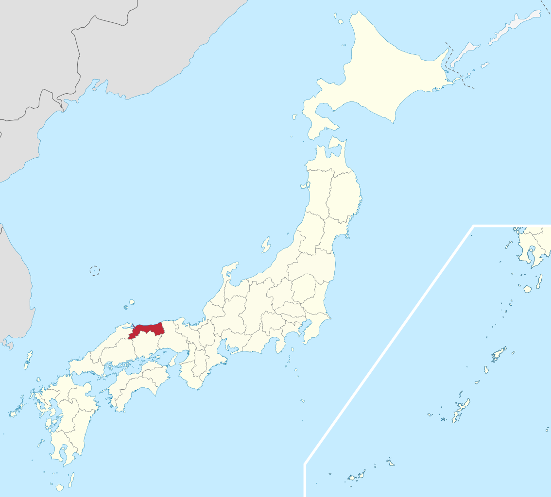
Tottori Prefecture (鳥取県, Tottori-ken) is a prefecture of Japan located in the Chūgoku region of Honshu. Tottori Prefecture is the least populous prefecture of Japan at 570,569 (2016) and has a geographic area of 3,510 square kilometres (1,360 sq mi). Tottori Prefecture borders Shimane Prefecture to the west, Hiroshima Prefecture to the southwest, Okayama Prefecture to the south, and Hyōgo Prefecture to the east. Tottori is the capital and largest city of Tottori Prefecture, with other major cities including Yonago, Kurayoshi, and Sakaiminato. Tottori Prefecture is home to the Tottori Sand Dunes, the largest sand dunes system in Japan, and Mount Daisen, the highest peak in the Chūgoku Mountains. (Source: Wikipedia.org, CC BY-SA)
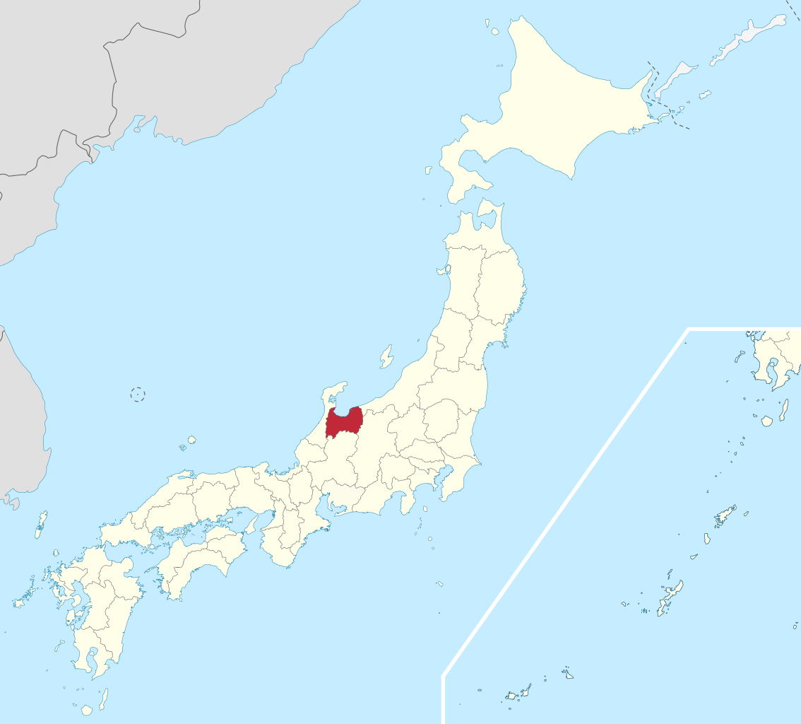
Toyama Prefecture (富山県, Toyama-ken) is a prefecture of Japan located in the Chūbu region of Honshu. Toyama Prefecture has a population of 1,044,588 (1 June 2019) and has a geographic area of 4,247.61 km2 (1,640.01 sq mi). Toyama Prefecture borders Ishikawa Prefecture to the west, Gifu Prefecture to the south, Nagano Prefecture to the east, and Niigata Prefecture to the northeast. Toyama is the capital and largest city of Toyama Prefecture, with other major cities including Takaoka, Imizu, and Nanto. Toyama Prefecture is part of the historic Hokuriku region, and the majority of prefecture's population lives on Toyama Bay, one of the largest bays in Japan. Toyama Prefecture is the leading industrial prefecture on the Japan Sea coast and has the advantage of cheap electricity from abundant hydroelectric resources. Toyama Prefecture contains the only known glaciers in East Asia outside of Russia, first recognized in 2012, and 30% of the prefecture's area is designated as national parks. (Source: Wikipedia.org, CC BY-SA)
Wakayama Prefecture (和歌山県, Wakayama-ken) is a prefecture of Japan located in the Kansai region of Honshu.: 1026 Wakayama Prefecture has a population of 944,320 (as of 1 October 2017) and has a geographic area of 4,724 square kilometres (1,824 sq mi). Wakayama Prefecture borders Osaka Prefecture to the north, and Mie Prefecture and Nara Prefecture to the northeast. Wakayama is the capital and largest city of Wakayama Prefecture, with other major cities including Tanabe, Hashimoto, and Kinokawa.: 1025 Wakayama Prefecture is located on the western coast of the Kii Peninsula on the Kii Channel, connecting the Pacific Ocean and Seto Inland Sea, across from Tokushima Prefecture on the island of Shikoku. (Source: Wikipedia.org, CC BY-SA)
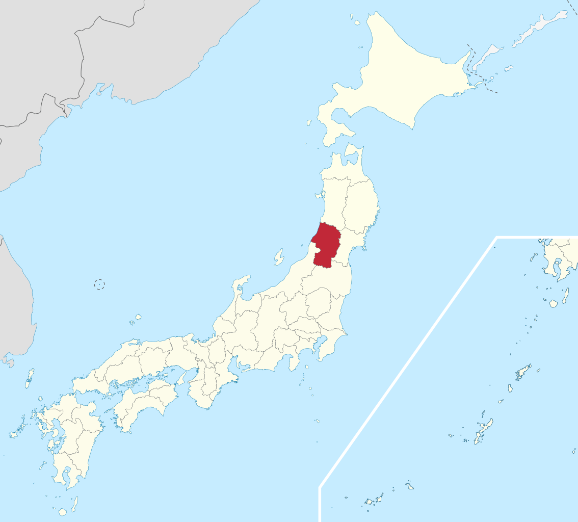
Yamagata Prefecture (山形県, Yamagata-ken) is a prefecture of Japan located in the Tōhoku region of Honshu. Yamagata Prefecture has a population of 1,079,950 (1 June 2019) and has a geographic area of 9,325 km2 (3,600 sq mi). Yamagata Prefecture borders Akita Prefecture to the north, Miyagi Prefecture to the east, Fukushima Prefecture to the south, and Niigata Prefecture to the southwest. Yamagata is the capital and largest city of Yamagata Prefecture, with other major cities including Tsuruoka, Sakata, and Yonezawa. Yamagata Prefecture is located on Japan's western Sea of Japan coast and its borders with neighboring prefectures are formed by various mountain ranges, with 17% of its total land area being designated as Natural Parks. Yamagata Prefecture formed the southern half of the historic Dewa Province with Akita Prefecture and is home to the Three Mountains of Dewa, which includes the Haguro Five-story Pagoda, a recognised National Treasure of Japan. (Source: Wikipedia.org, CC BY-SA)
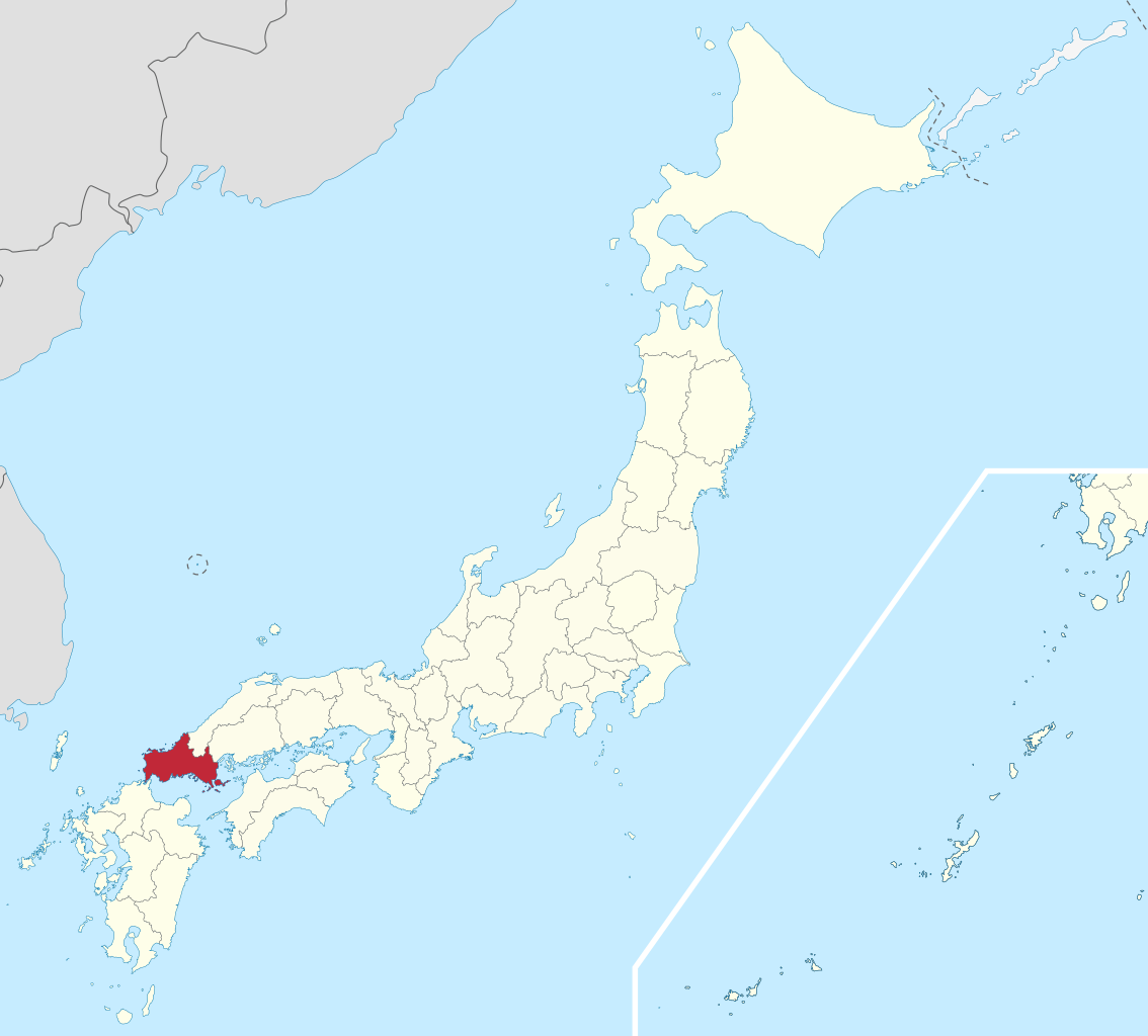
Yamaguchi Prefecture (山口県, Yamaguchi-ken) is a prefecture of Japan located in the Chūgoku region of Honshu. Yamaguchi Prefecture has a population of 1,377,631 (1 February 2018) and has a geographic area of 6,112 km2 (2,359 sq mi). Yamaguchi Prefecture borders Shimane Prefecture to the north and Hiroshima Prefecture to the northeast. Yamaguchi is the capital and Shimonoseki is the largest city of Yamaguchi Prefecture, with other major cities including Ube, Shūnan, and Iwakuni. Yamaguchi Prefecture is located at the western tip of Honshu with coastlines on the Sea of Japan and Seto Inland Sea, and separated from the island of Kyushu by the Kanmon Straits. (Source: Wikipedia.org, CC BY-SA)
Yamanashi Prefecture (山梨県, Yamanashi-ken) is a prefecture of Japan located in the Chūbu region of Honshu. Yamanashi Prefecture has a population of 817,192 (1 January 2019) and has a geographic area of 4,465 km2 (1,724 sq mi). Yamanashi Prefecture borders Saitama Prefecture to the northeast, Nagano Prefecture to the northwest, Shizuoka Prefecture to the southwest, Kanagawa Prefecture to the southeast, and Tokyo to the east. Kōfu is the capital and largest city of Yamanashi Prefecture, with other major cities including Kai, Minamiarupusu, and Fuefuki. Yamanashi Prefecture is one of only eight landlocked prefectures, and the majority of the population lives in the central Kōfu Basin surrounded by the Akaishi Mountains, with 27% of its total land area being designated as Natural Parks. Yamanashi Prefecture is home to many of the highest mountains in Japan, and Mount Fuji, the tallest mountain in Japan and cultural icon of the country, is partially located in Yamanashi Prefecture on the border with Shizuoka Prefecture. (Source: Wikipedia.org, CC BY-SA)
Ōita Prefecture (大分県, Ōita-ken) is a prefecture of Japan located on the island of Kyūshū. Ōita Prefecture has a population of 1,136,245 (1 June 2019) and has a geographic area of 6,340 km2 (2,448 sq mi). Ōita Prefecture borders Fukuoka Prefecture to the northwest, Kumamoto Prefecture to the southwest, and Miyazaki Prefecture to the south. Ōita is the capital and largest city of Ōita Prefecture, with other major cities including Beppu, Nakatsu, and Saiki. Ōita Prefecture is located in the northeast of Kyūshū on the Bungo Channel, connecting the Pacific Ocean and Seto Inland Sea, across from Ehime Prefecture on the island of Shikoku. Ōita Prefecture is famous for its hot springs and is a popular tourist destination in Japan for its onsens and ryokans, particularly in and around the city of Beppu. (Source: Wikipedia.org, CC BY-SA)

Time for recess! Post a comment, ask a question or write a review. Feel free to let us know what you think!
look at the sign on the road to avoid accidents and horrible driving conditions
 -3
-3
I received a 300$ ticket because I passed a police control of other cars/drivers on the right lane of a highway (the control was on the hard shoulder of the highway). Is it really true, that you have to change the lane in such cases? Thanks!
I am an American living in Italy. The Italian Drivers License theory test is the hardest test I have ever studied for and I am in my 70s have multiple degrees, multiple professional certifications. Have to take the Italian Drivers Theory test in Italian. No english. So many rules. More signs in small medieval Italian town I live in then in major US cities I have lived in. No Italian license no driving. No buying or renting a car. Test here was good, clean. Lots of tricky questions on many practice and real official tests. Thanks
Most problems are a result of higher than safe driving speeds. Please just slow down and be patient.
Question 121: Poor translation: Vehicles with polluted fluids prohibited Should be translated as: Vehicles with dangerous liquids prohibited
Question 83: Poor translation: Vehicles with polluted fluids prohibited Should be translated as: Vehicles with dangerous liquids prohibited
0
Want even more practice? Visit similar websites offering realistic practice driving knowledge tests. Visit us to see what sets our tests apart! https://dkttest.com/capital-territory/
Cool tool! And fun to check whether I remember the rules :) Two things I noticed: Warning for a crossroad side roads on the left and right. While technically that might be the correct translation, this sign tells you, that you are on the main road and have the right of way for the next crossroad and only the next crossroad. Usually (if no sign specifies otherwise) you have to give way to drivers coming from the right at every intersection, which can get a bit annoying in communal areas, so seeing this sign feels less like a warning and more like relief :). A Fahrradstraße is not a lane for cyclists but a street for cyclists, meaning the (whole!) street is intended predominantly for cyclists, who are then allowed to ride next to each other. Cars are allowed to drive there (unless another sign prohibits such), but have to adjust their speed to the cyclists. I believe they are not allowed to pass at all, even if the oncoming lane is empty.


More community