

Here you can study for the exam. Look up keywords and learn definitions about all kind of subjects.
More subjects
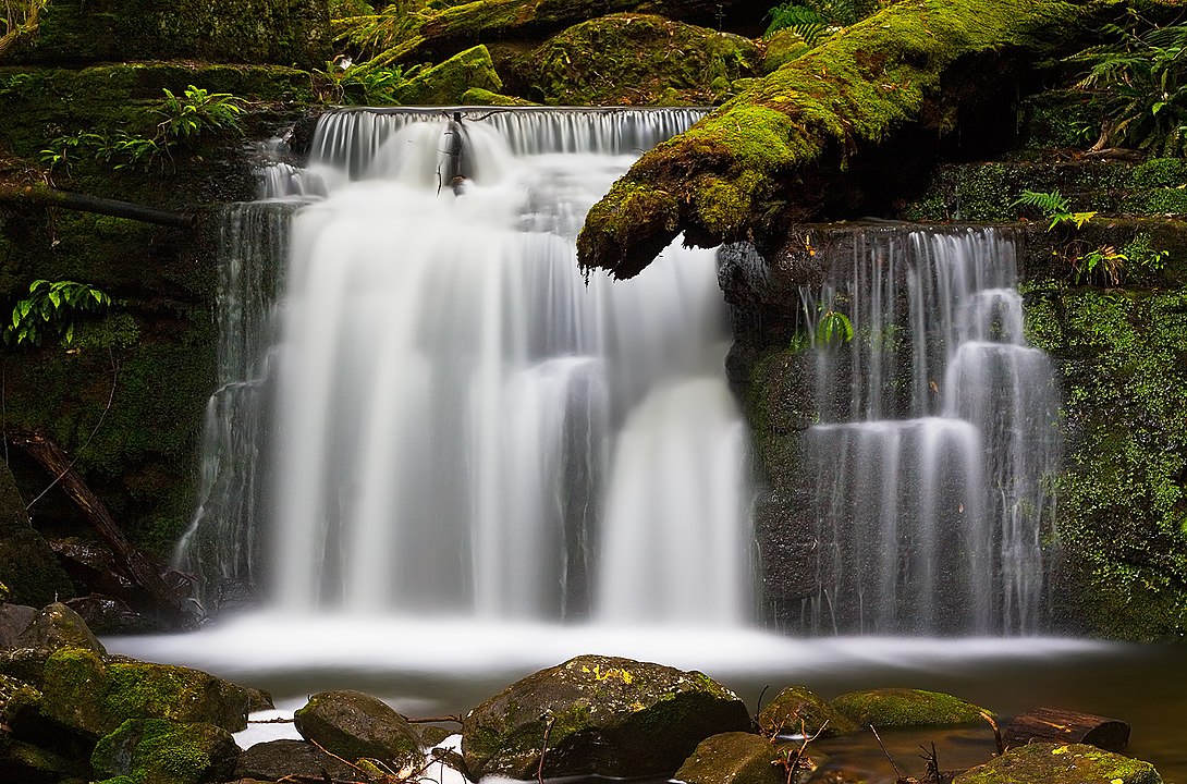
The Hobart Rivulet, part of the River Derwent catchment, is an urban stream located in the Hobart hinterland and flows through and underneath the city, in Tasmania, Australia. The rivulet rises on the slopes of Mount Wellington and flows generally northeast over O'Grady's Falls, Strickland Falls, through South Hobart and past what was known as the World Heritage-listed Cascades Female Factory towards the Hobart central business district. As a result of urban development, the natural course has been altered significantly. The lower portion of the rivulet has been piped through the city and runs below the central city area. The rivulet emerges again near the Royal Hobart Hospital on Collins Street before flowing underneath the Cenotaph and emptying into the Derwent. The rivulet descends 544 metres (1,785 ft) over its 7.3-kilometre (4.5 mi) course. (Source: Wikipedia.org, CC BY-SA)
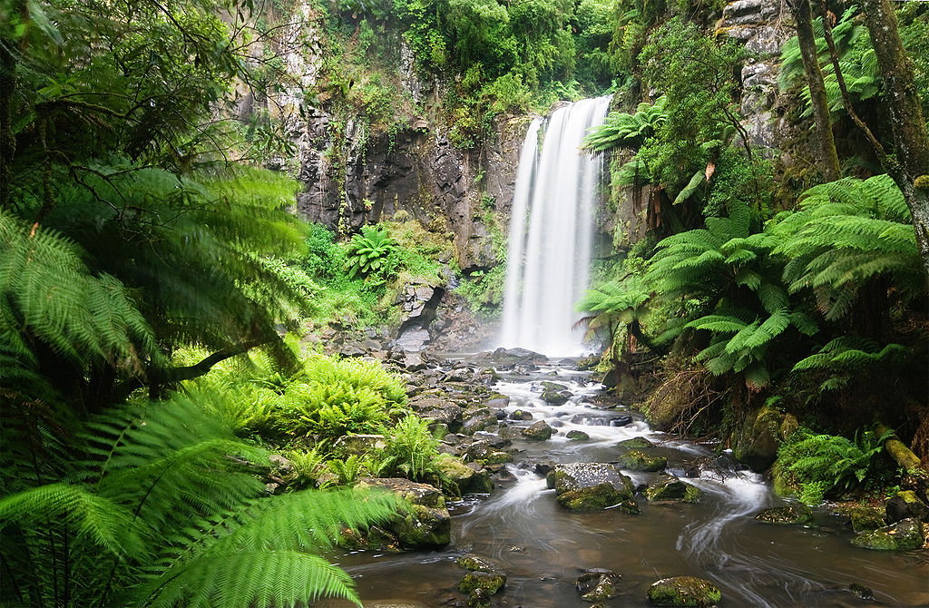
The Hopetoun Falls is a waterfall across the Aire River that is located in the Otways region of Victoria, Australia. The falls are located approximately 5 kilometres (3.1 mi) south of the locality of Beech Forest at an elevation of 314 metres (1,030 ft) above sea level and range between 45–49 metres (148–161 ft) in height. Hopetoun Falls adjacent to the Apollo Bay – Beech Forest Road about 4 kilometres (2.5 mi) south of the Beauchamp Falls turnoff and roughly 20 kilometres (12 mi) northwest of the coastal town of Apollo Bay. Much attention has been given to preserving the natural characteristics of Hopetoun Falls while allowing ample access for visitors. The falls have a large set of well-built and maintained stairs that lead down a natural patio to a viewing platform very close to the foot of the waterfall. Hopetoun Falls plunges 30 m in a rectangular shape. (Source: Wikipedia.org, CC BY-SA)
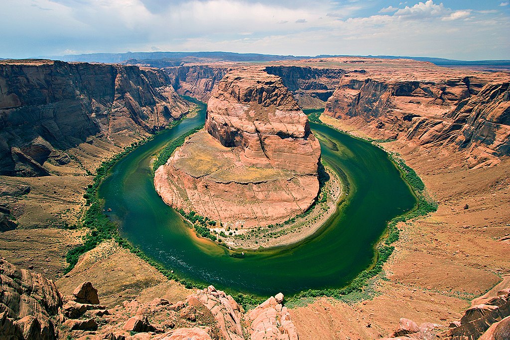
Horseshoe Bend is a horseshoe-shaped incised meander of the Colorado River located near the town of Page, Arizona, United States. It is also referred to as the 'east rim of the Grand Canyon.' Horseshoe Bend is located 5 miles (8 km) downstream from the Glen Canyon Dam and Lake Powell within Glen Canyon National Recreation Area, about 4 miles (6 km) southwest of Page. It is accessible via hiking a 1.5-mile (2.4 km) round trip from a parking area just off U.S. Route 89 within southwestern Page. The land south of the Bend's parking area, trail, and overlook are on the Navajo Nation territory. The overlook is 4,200 feet (1,300 m) above sea level, and the Colorado River is at 3,200 feet (1,000 m) above sea level, making it a 1,000-foot (300 m) drop. (Source: Wikipedia.org, CC BY-SA)
 © Wikimedia.org/Moondigger, CC BY-SA
Jade Dragon Snow Mountain (simplified Chinese: 玉龙雪山; traditional Chinese: 玉龍雪山; pinyin: Yùlóng Xuěshān; Naxi: Jingv'lv or Ngv'lv bbei jjuq) is a mountain massif or small mountain range in Yulong Naxi Autonomous County, Lijiang, in Yunnan province, China. Its highest peak is named Shanzidou or Shan-Tzu-tou (扇子陡) and it is 5,596 m (18,360 ft) above sea level. The Jade Dragon Snow Mountain massif forms the bulk of the larger Yulong Mountains, that stretch further north. The northwestern flank of the massif forms one side of the Tiger Leaping Gorge (Hǔtiào Xiá, 虎跳峡), which has a popular trekking route on the other side. In this gorge, the Jinsha (upper Yangtze) River descends dramatically between Jade Dragon and Haba Snow Mountain. The Yulong Mountains lie to the south of the Yun Range and are part of Southwest China's greater Hengduan Mountains. (Source: Wikipedia.org, CC BY-SA)
Mount Jalovec (pronounced [ˈjaːlɔʋəts]; Italian: Monte Gialuz) is a mountain in the Julian Alps. With an elevation of 2,645 m, it is the sixth-highest peak in Slovenia. It stands between the Tamar, Koritnica, and Trenta Alpine valleys. Nearby peaks include Mangart to the west, Travnik and Mojstrovka to the east, and Ponce to the north. The Log Cliff (Slovene: Loška stena, Italian: Parete di Bretto) stands immediately southwest of Mount Jalovec. Mount Jalovec was attested in written sources as early as 1763–87 as Jellauz and Jelauz. The name is derived from the Slovene adjective jalov 'barren, infertile', referring to the lack of vegetation on the slopes of the mountain. (Source: Wikipedia.org, CC BY-SA)
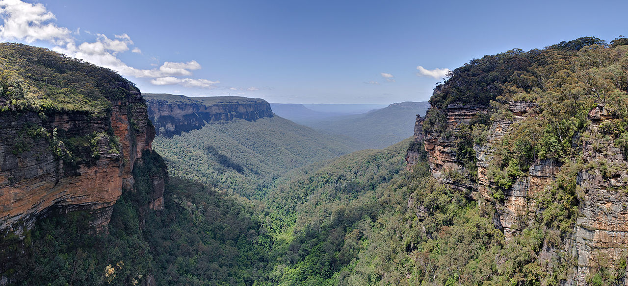
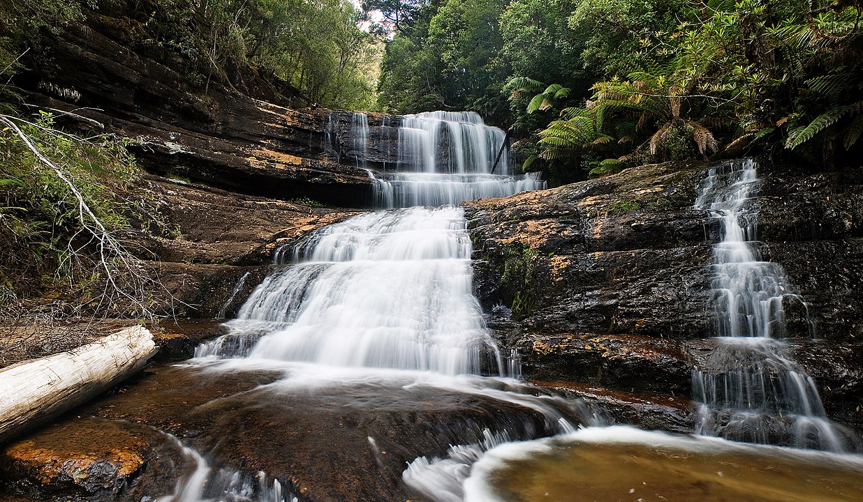
The Jamison Valley forms part of the Coxs River canyon system in the Blue Mountains of New South Wales, Australia. It is situated approximately 100 kilometres west of Sydney, capital of New South Wales, and a few kilometres south of Katoomba, the main town in the Blue Mountains. The Jamison Valley stretches north-south from just outside Katoomba to the Mount Solitary ridge; in this direction it is approximately 4 kilometres (2.5 mi) long. From west to east, it stretches from Narrow Neck Plateau to Kings Tableland, making it approximately 10 kilometres (6.2 mi) wide. Like the entire Sydney and Blue Mountains region, the valley is a sandstone area, characterised by steep sandstone cliffs. Deeper into the soil there is a layer of shale, which is softer than the sandstone. As this layer of shale was eroded by the watercourses, it collapsed and brought the sandstone down with it, creating the characteristic sandstone valleys and canyons of the Blue Mountains, of which the Jamison Valley is one. (Source: Wikipedia.org, CC BY-SA)
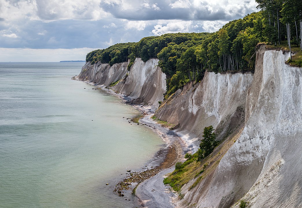
The Jasmund National Park (German: Nationalpark Jasmund) is a nature reserve on the Jasmund peninsula, in the northeast of Rügen island in Mecklenburg-Vorpommern, Germany. It is famous for containing the largest chalk cliffs in Germany, the Königsstuhl (German = 'king's chair'). These cliffs are up to 161 m (528 ft) above the Baltic Sea. The beech forests behind the cliffs are also part of the national park. Consisting of only 30 km2 (12 sq mi), this is the smallest national park in Germany. The park was founded in 1990 by the last government of East Germany (GDR) prior to the German reunification. On June 25, 2011, the beech forest in the park was added to the UNESCO World Heritage List as an extension of the Primeval Beech Forests of Europe site because of its undisturbed nature and its testimony to the ecological history of Europe since the last Ice Age. (Source: Wikipedia.org, CC BY-SA)
Joshua Tree National Park is an American national park in southeastern California, east of San Bernardino and Los Angeles and north of Palm Springs. It is named after the Joshua trees (Yucca brevifolia) native to the Mojave Desert. Originally declared a national monument in 1936, Joshua Tree was redesignated as a national park in 1994 when the U.S. Congress passed the California Desert Protection Act. Encompassing a total of 795,156 acres (1,242.4 sq mi; 3,217.9 km2) – slightly larger than the state of Rhode Island – the park includes 429,690 acres (671.4 sq mi; 1,738.9 km2) of designated wilderness. Straddling San Bernardino and Riverside Counties, the park includes parts of two deserts, each an ecosystem whose characteristics are determined primarily by elevation: the higher Mojave Desert and the lower Colorado Desert. The Little San Bernardino Mountains traverse the southwest edge of the park. (Source: Wikipedia.org, CC BY-SA)
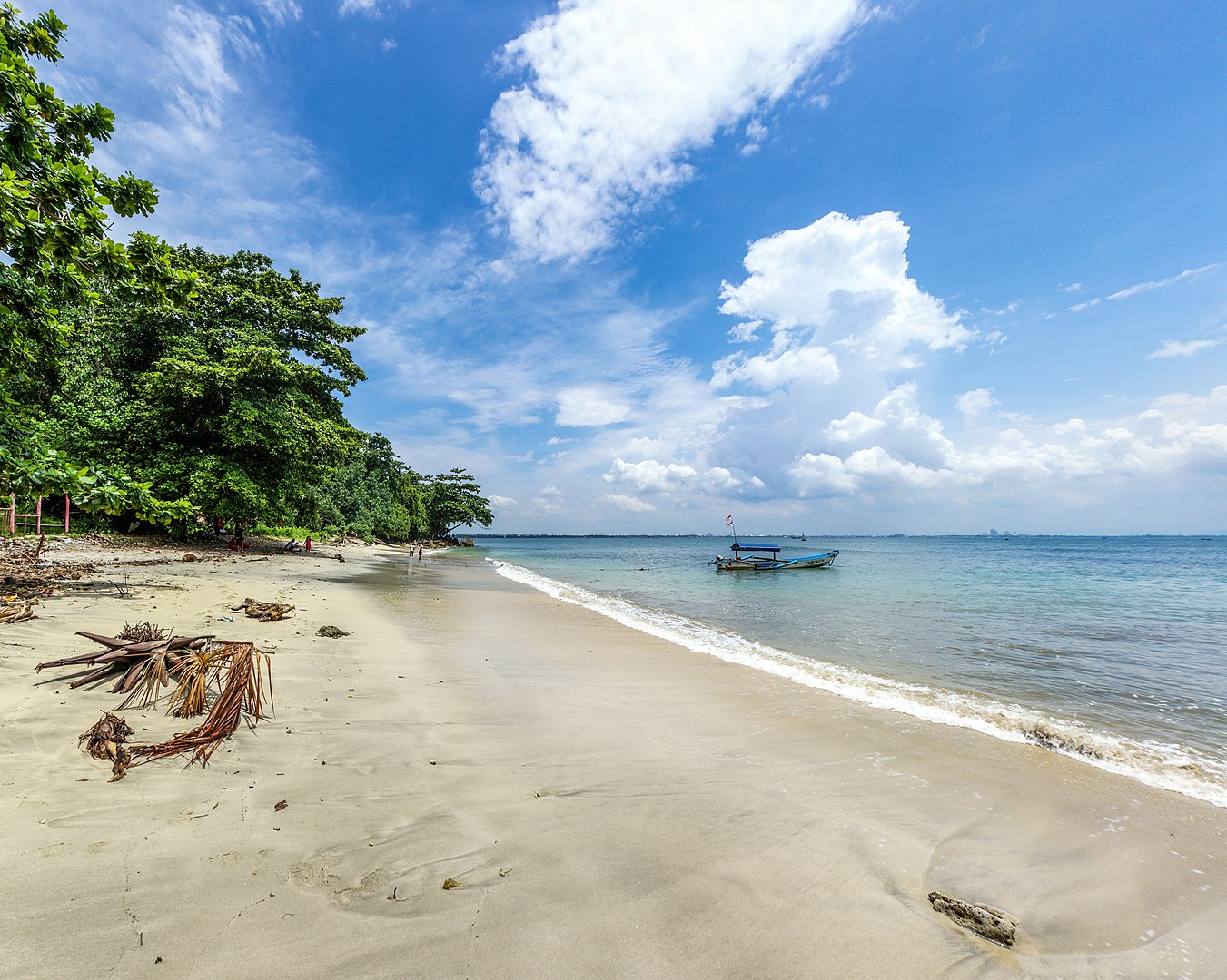
Karang Bolong Beach (Indonesian for 'Holed Coral') is a white-sand beach on the island of Nusa Kambangan in Cilacap Regency, Central Java. Located on the eastern end of the island inside a nature reserve, the beach is situated near an old Dutch fortress, also known as Karang Bolong. On the path between the western and eastern portions of the beach is a fortress, known as Karang Bolong. This fortress was built by the Dutch colonial forces in about 1873, and was given its Indonesian name for its location close to the beach. The fortress, which covers 12,000 square metres (130,000 sq ft), has been damaged by exposure to elements, and is covered in vegetation. Many of its artefacts have been stolen, though cannons can still be found. Near the western edge of the beach is a waterfall, known as Grojogan Sewu. It is so named because it consists of a thousand short drops. (Source: Wikipedia.org, CC BY-SA)
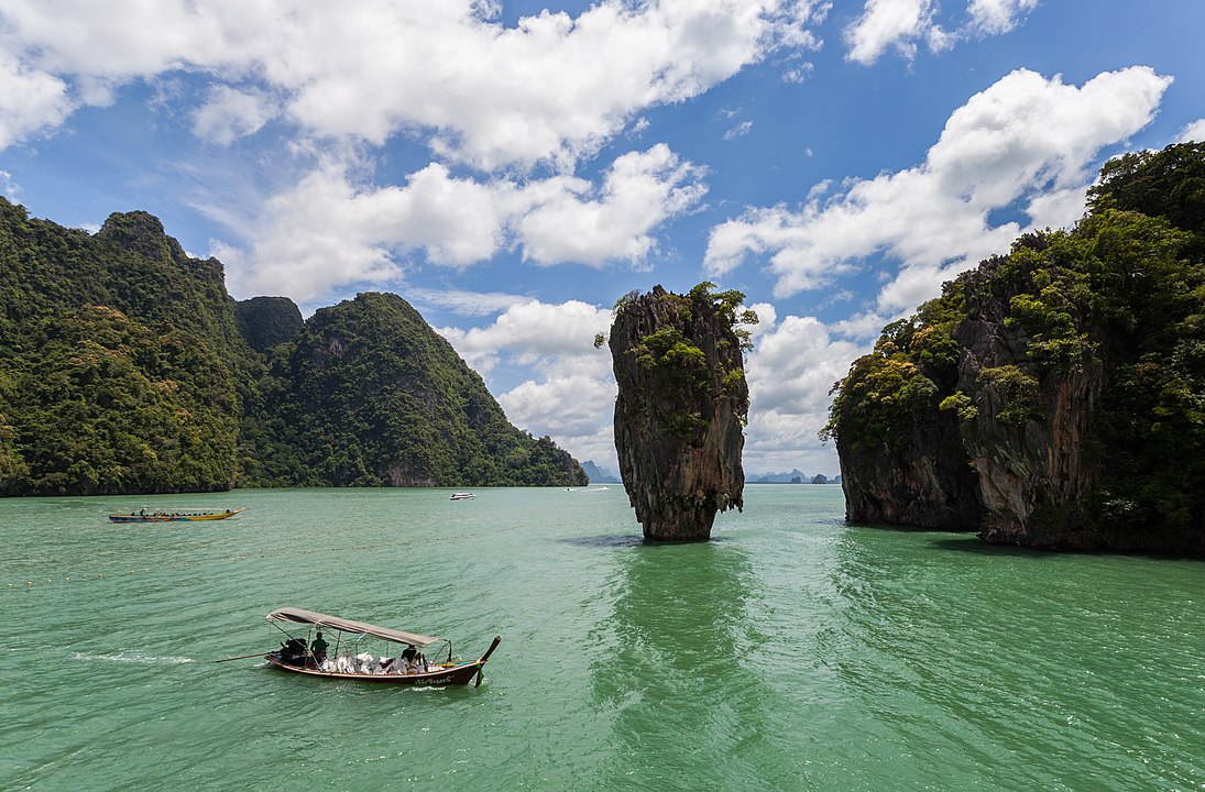
Khao Phing Kan (Thai: เขาพิงกัน, pronounced [kʰǎw pʰīŋ kān]) or Ko Khao Phing Kan (เกาะเขาพิงกัน, [kɔ̀ʔ kʰǎw pʰīŋ kān]) is an island in Thailand, in Phang Nga Bay northeast of Phuket. About 40 metres (130 ft) from the shores of Khao Phing Kan lies a 20-metre (66 ft) tall islet called Ko Ta Pu (เกาะตาปู, [kɔ̀ʔ tāː pūː]) or Ko Tapu (เกาะตะปู, [kɔ̀ʔ tā.pūː]). The islands are limestone karst towers and are a part of Ao Phang Nga National Park. Since 1974, when they were featured in the James Bond movie The Man with the Golden Gun, Khao Phing Kan and Ko Ta Pu – both separately and collectively – have been popularly called James Bond Island. (Source: Wikipedia.org, CC BY-SA)
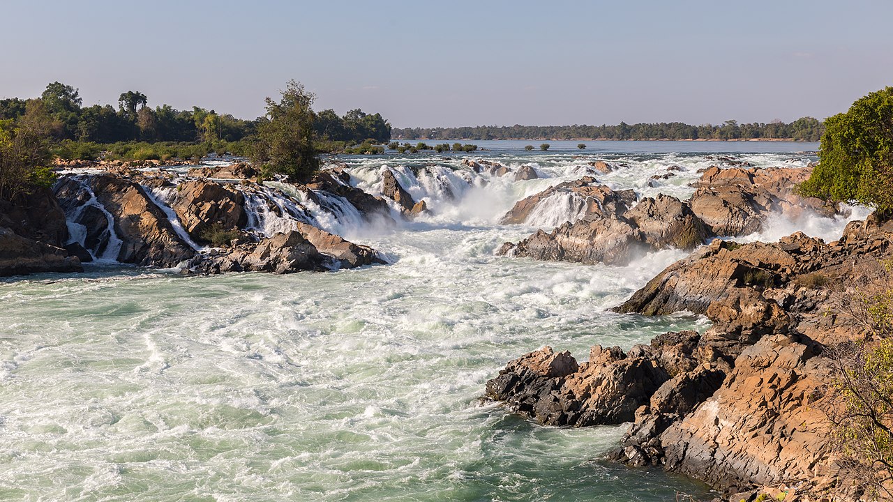
The Khone Phapheng Falls (Lao: ນ້ຳຕົກຕາດຄອນພະເພັງ; Khmer: ល្បាក់ខោន, Lbak Khaon) together form a waterfall located in Champasak Province on the Mekong River in southern Laos, near the border with Cambodia. It is the widest waterfall in the world at 10,783 metres (35,376 feet or 6.7 miles) in width from one edge of its multiple channels to the other. The Khone Falls are the largest in southeast Asia, and are the main reason that the Mekong is not fully navigable into China. The falls are characterised by thousands of islands and countless waterways, giving the area its name Si Phan Don or 'the 4,000 islands'. The highest falls reach to 21 metres (69 ft); the succession of rapids stretch 9.7 km (6.0 mi) of the river's length. The average discharge of the cataract is nearly 11,000 m3/s (390,000 cu ft/s), with the highest flow on record at over 49,000 m3/s (1,700,000 cu ft/s). (Source: Wikipedia.org, CC BY-SA)
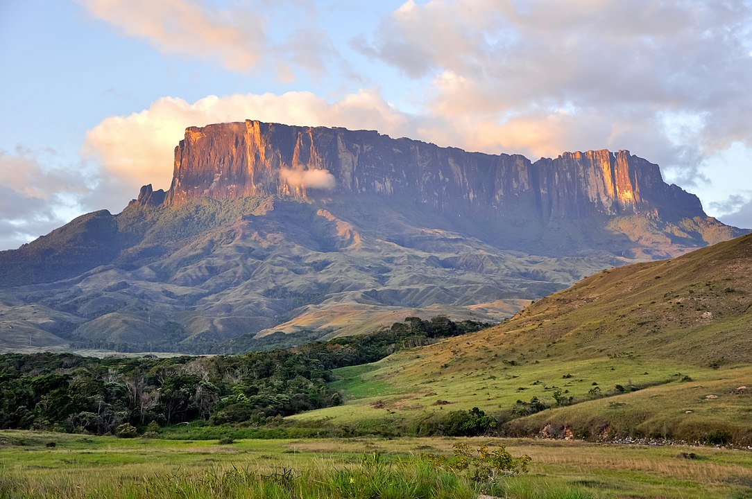
Kukenán-tepui, also known as Matawi or Cuquenán, is a tepui in Bolívar State, Guayana Region, Venezuela. It has an estimated surface area of 2185 hectares (equivalent to 21.85 square kilometres). It is 2,680 metres (8,790 ft) high and about 3 km (1.9 mi) long. Kukenan Falls, which is 674 m (2,211 ft) high, is located at the south end of the tepui. Kukenán is located in Canaima National Park. Next to Kukenán, to the southeast, is Mount Roraima, a better known tepui. Kukenán is more difficult to climb, so it is ascended much less frequently than Mount Roraima. Canaima National Park is also home to the highest waterfall in the world, which is located in Auyán Tepui. (Source: Wikipedia.org, CC BY-SA)
The Lady Barron Falls, a tiered–cascade waterfall on the Lady Barron Creek, is located in the Central Highlands region of Tasmania, Australia. The Lady Barron Falls are situated in the Mount Field National Park, a short distance from Russell Falls, approximately 70 kilometres (43 mi) northwest of Hobart via the Brooker and Lyell highways; and are a popular tourist attraction. The waterfall descends over horizontal marine Permian siltstone benches, while the vertical faces of the falls are composed of resistant sandstone layers. (Source: Wikipedia.org, CC BY-SA)
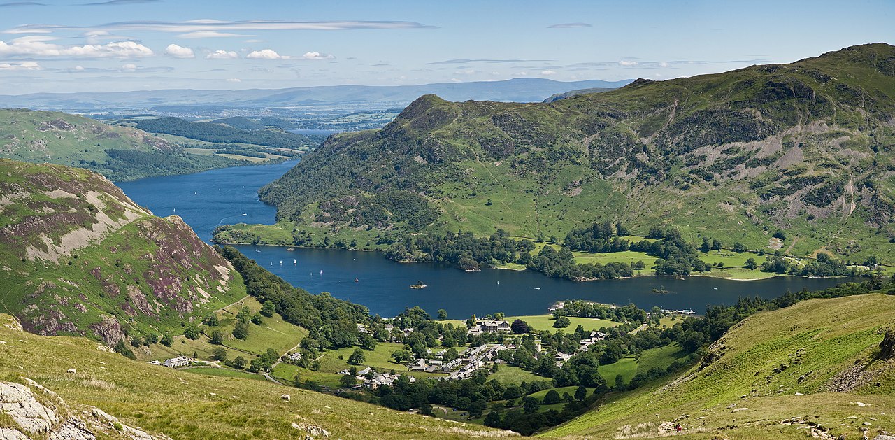
The Lake District, also known as the Lakes or Lakeland, is a mountainous region in North West England. A popular holiday destination, it is famous for its lakes, forests, and mountains, and its associations with William Wordsworth and other Lake Poets and also with Beatrix Potter and John Ruskin. The Lake District National Park was established in 1951 and covers an area of 2,362 square kilometres (912 sq mi). It was designated a UNESCO World Heritage Site in 2017. The Lake District is today completely within Cumbria, and its mountains (or 'fells') are sometimes called the Cumbrian Mountains. Historically it was divided between three English counties (Cumberland, Westmorland and Lancashire), sometimes referred to as the Lakes Counties. The three counties met at the Three Shire Stone on Wrynose Pass in the southern fells west of Ambleside. It is now divided between the modern council areas of Cumberland and Westmorland and Furness (Source: Wikipedia.org, CC BY-SA)
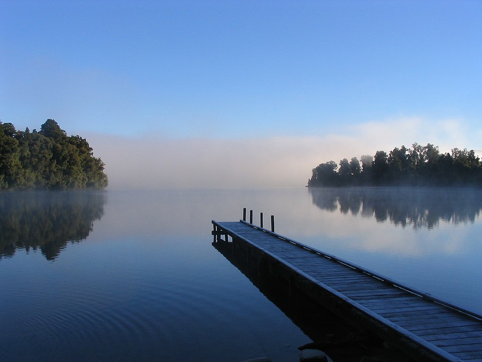
Lake Mapourika is located on the West Coast of New Zealand's South Island. It lies north of Franz Josef Glacier, and the out-flowing Ōkārito River drains it into the Ōkārito Lagoon. It is the largest of the West Coast lakes, a glacier formation from the last ice age. Since the water from glacial melts no longer drains into the lake, it is filled with fresh rain water which runs through the surrounding forest floor, collecting tannins, giving it its dark colour. As the winds of the region sweep high above the mountains of the Southern Alps, the water is left unruffled and quite reflective of the forest on the lake fringes. (Source: Wikipedia.org, CC BY-SA)
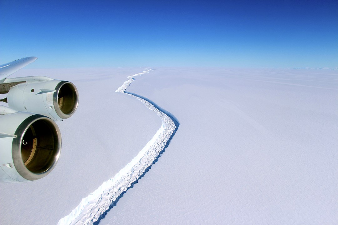
The Larsen Ice Shelf is a long ice shelf in the northwest part of the Weddell Sea, extending along the east coast of the Antarctic Peninsula from Cape Longing to Smith Peninsula. It is named after Captain Carl Anton Larsen, the master of the Norwegian whaling vessel Jason, who sailed along the ice front as far as 68°10' South during December 1893. In finer detail, the Larsen Ice Shelf is a series of shelves that occupy (or occupied) distinct embayments along the coast. From north to south, the segments are called Larsen A (the smallest), Larsen B, and Larsen C (the largest) by researchers who work in the area. Further south, Larsen D and the much smaller Larsen E, F and G are also named. (Source: Wikipedia.org, CC BY-SA)
 © Wikimedia.org/NASA - John Sonntag, CC0
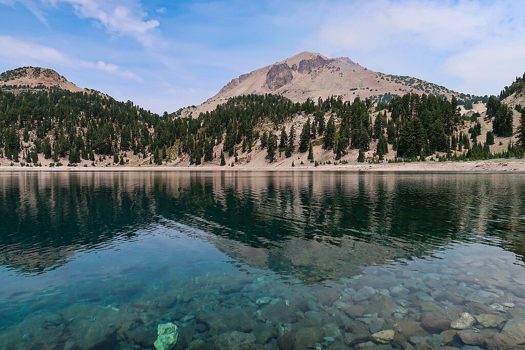
Lassen Volcanic National Park is an American national park in northeastern California. The dominant feature of the park is Lassen Peak, the largest plug dome volcano in the world and the southernmost volcano in the Cascade Range. Lassen Volcanic National Park is one of the few areas in the world where all four types of volcano can be found—plug dome, shield, cinder cone, and stratovolcano. The source of heat for the volcanism in the Lassen area is subduction of the Gorda Plate diving below the North American Plate off the Northern California coast. The area surrounding Lassen Peak is still active with boiling mud pots, fumaroles, and hot springs. (Source: Wikipedia.org, CC BY-SA)
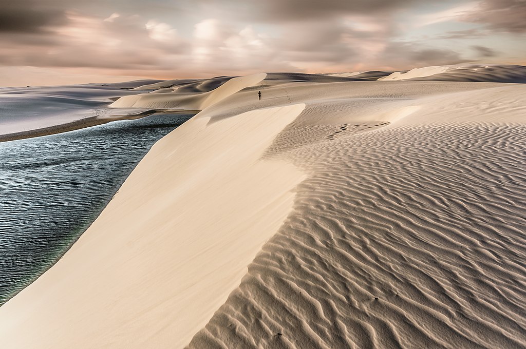
Lençóis Maranhenses National Park (Parque Nacional dos Lençóis Maranhenses) is a national park in Maranhão state in northeastern Brazil, just east of the Baía de São José. Protected on June 2, 1981, the 155,000 ha (380,000-acre) park includes 70 km (43 mi) of coastline, and an interior composed of rolling sand dunes. During the rainy season, the valleys among the dunes fill with freshwater lagoons, prevented from draining due to the impermeable rock beneath. The park is home to a range of species, including four listed as endangered, and has become a popular destination for ecotourists. (Source: Wikipedia.org, CC BY-SA)
 © Wikimedia.org/Dlaurini, CC BY-SA
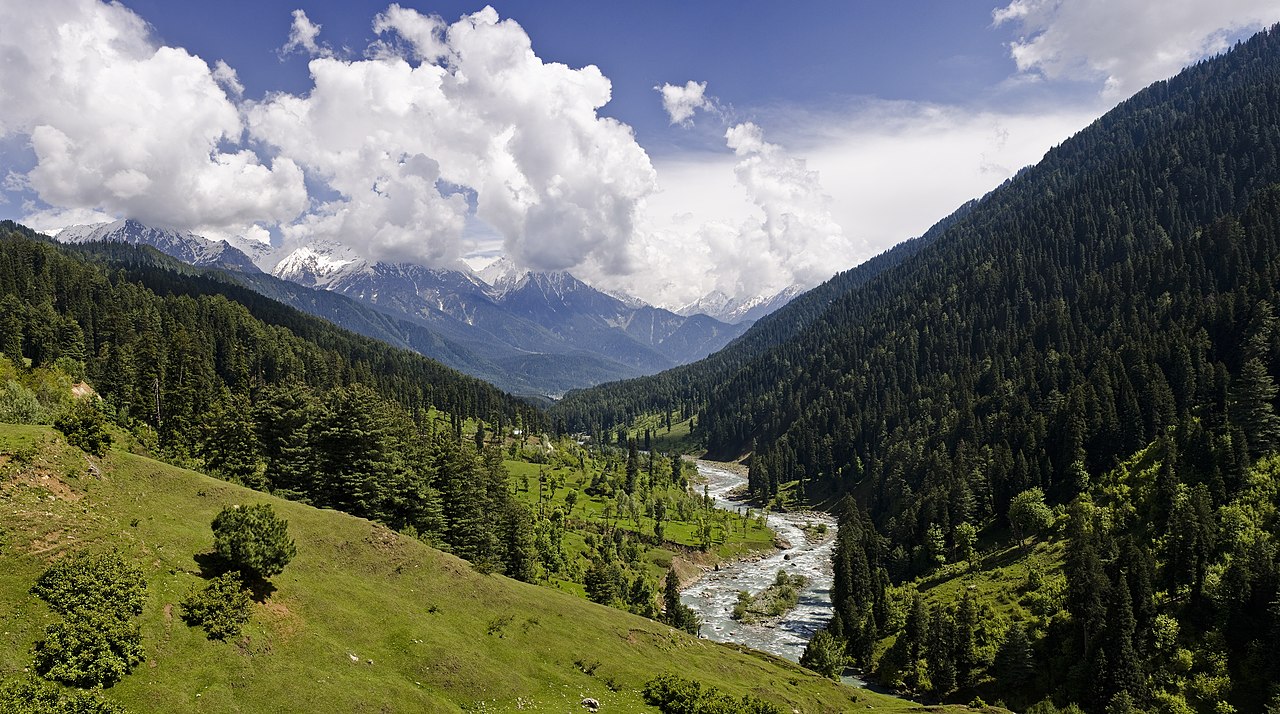
The Lidder Valley or Liddar Valley is a Himalayan sub-valley that forms the southeastern corner of Anantnag district in Indian-administered Kashmir. The Lidder River flows down the valley. The entrance to the valley lies 7 km northeast from Anantnag town and 62 km southeast from Srinagar, the summer capital of Jammu and Kashmir. It is a 40-km-long gorge valley with an average width of 3 km. The Lidder Valley formed over millions of years as the Lidder River cut into the Himalayan Mountains. Today, the river continues to deposit sheets of sand in the lower areas of Anantnag. Gradual erosive processes have washed away bordering forests and created deep gorges at many places. (Source: Wikipedia.org, CC BY-SA)
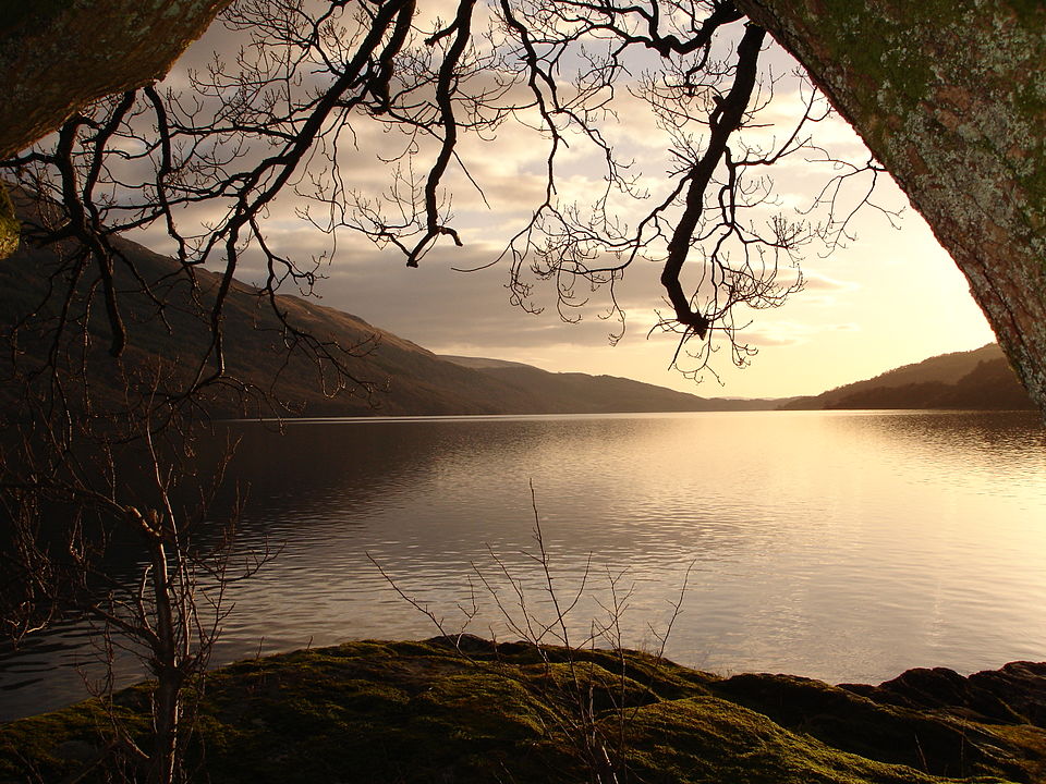
Loch Lomond (/ˈlɒx ˈloʊmənd/; Scottish Gaelic: Loch Laomainn - 'Lake of the Elms') is a freshwater Scottish loch which crosses the Highland Boundary Fault, often considered the boundary between the lowlands of Central Scotland and the Highlands. Traditionally forming part of the boundary between the counties of Stirlingshire and Dunbartonshire, Loch Lomond is split between the council areas of Stirling, Argyll and Bute and West Dunbartonshire. Its southern shores are about 23 kilometres (14 mi) northwest of the centre of Glasgow, Scotland's largest city. The Loch forms part of the Loch Lomond and The Trossachs National Park which was established in 2002. Loch Lomond is 36.4 kilometres (22.6 mi) long and between 1 and 8 kilometres (0.62–4.97 mi) wide, with a surface area of 71 km2 (27.5 sq mi). (Source: Wikipedia.org, CC BY-SA)
 © Wikimedia.org/Abubakr Hussain, CC BY-SA
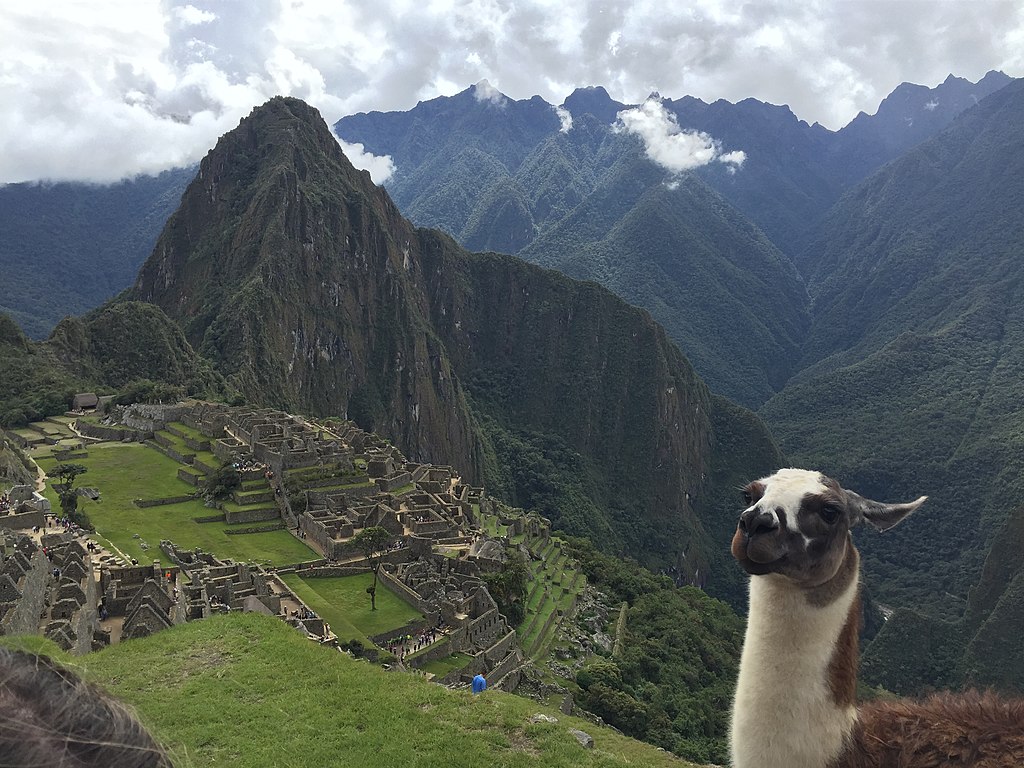
Machu Picchu is a 15th-century Inca citadel located in the Eastern Cordillera of southern Peru on a 2,430-meter (7,970 ft) mountain ridge. Often referred to as the 'Lost City of the Incas', it is the most familiar icon of the Inca Empire. It is located in the Machupicchu District within Urubamba Province above the Sacred Valley, which is 80 kilometers (50 mi) northwest of Cusco. The Urubamba River flows past it, cutting through the Cordillera and creating a canyon with a tropical mountain climate. The Inca civilization had no written language and no European visited the site until the 19th century, so far as is known, so there are no written records of the site while it was in use. The names of the buildings, their supposed uses, and their inhabitants are the product of modern archaeologists on the basis of physical evidence, including tombs at the site. (Source: Wikipedia.org, CC BY-SA)
 © Wikimedia.org/Richard H. Moore, CC BY-SA
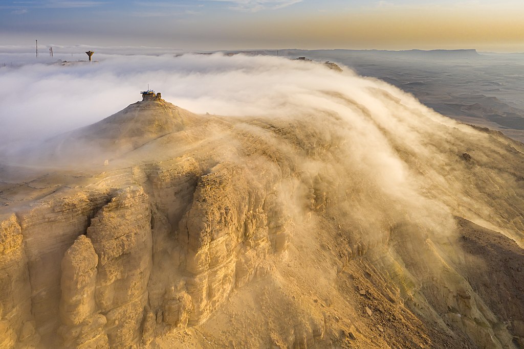
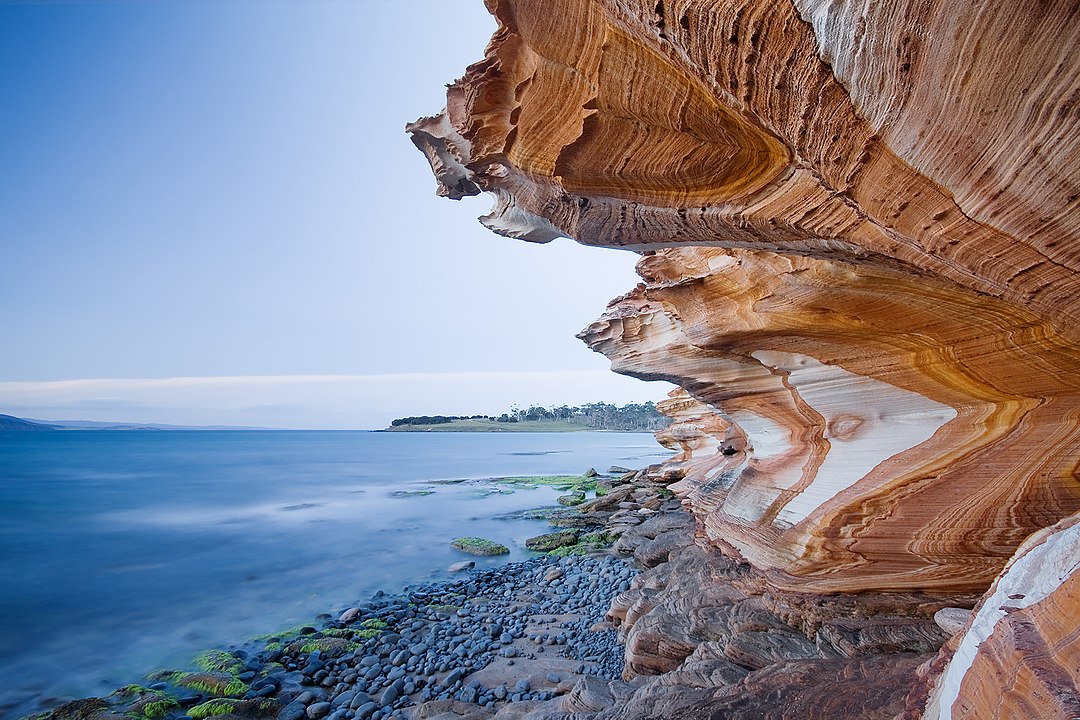
Makhtesh Ramon (Hebrew: מכתש רמון; lit. Ramon Crater/Makhtesh ; Arabic: وادي الرمان; lit. The Ruman Wadi) is a geological feature of Israel's Negev desert. Located some 85 km south of the city of Beersheba, the landform is the world's largest 'erosion cirque' (steephead valley or box canyon). The formation is 40 km long, 2–10 km wide and 500 meters deep, and is shaped like an elongated heart. Despite its appearance it is not an impact crater from a meteor nor a volcanic crater formed by a volcanic eruption. The only settlement in the area is the small town of Mitzpe Ramon (מצפה רמון, 'Ramon Lookout') located on the northern edge of the depression. Today the area forms Israel's largest national park, the Ramon Nature Reserve. (Source: Wikipedia.org, CC BY-SA)
 © Wikimedia.org/Giladtop, CC BY-SA
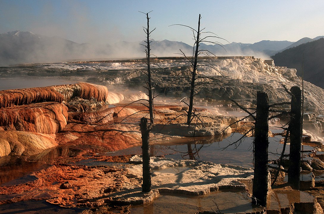
Mammoth Hot Springs is a large complex of hot springs on a hill of travertine in Yellowstone National Park adjacent to Fort Yellowstone and the Mammoth Hot Springs Historic District. It was created over thousands of years as hot water from the spring cooled and deposited calcium carbonate (over two tons flow into Mammoth each day in a solution). Because of the huge amount of geothermal vents, travertine flourishes. Although these springs lie outside the caldera boundary, their energy has been attributed to the same magmatic system that fuels other Yellowstone geothermal areas. (Source: Wikipedia.org, CC BY-SA)
 © Wikimedia.org/Brocken Inaglory, CC BY-SA
Maria Island or 'wukaluwikiwayna' in [palawa kani) is a mountainous island located in the Tasman Sea, off the east coast of Tasmania, Australia. The 115.5-square-kilometre (44.6 sq mi) island is contained within the Maria Island National Park, which includes a marine area of 18.78 square kilometres (7.25 sq mi) off the island's northwest coast. The island is about 20 kilometres (12 mi) in length from north to south and, at its widest, is about 13 kilometres (8.1 mi) west to east. At its closest point, Point Lesueur, the island lies approximately 4 kilometres (2.5 mi) off the east coast of Tasmania. (Source: Wikipedia.org, CC BY-SA)
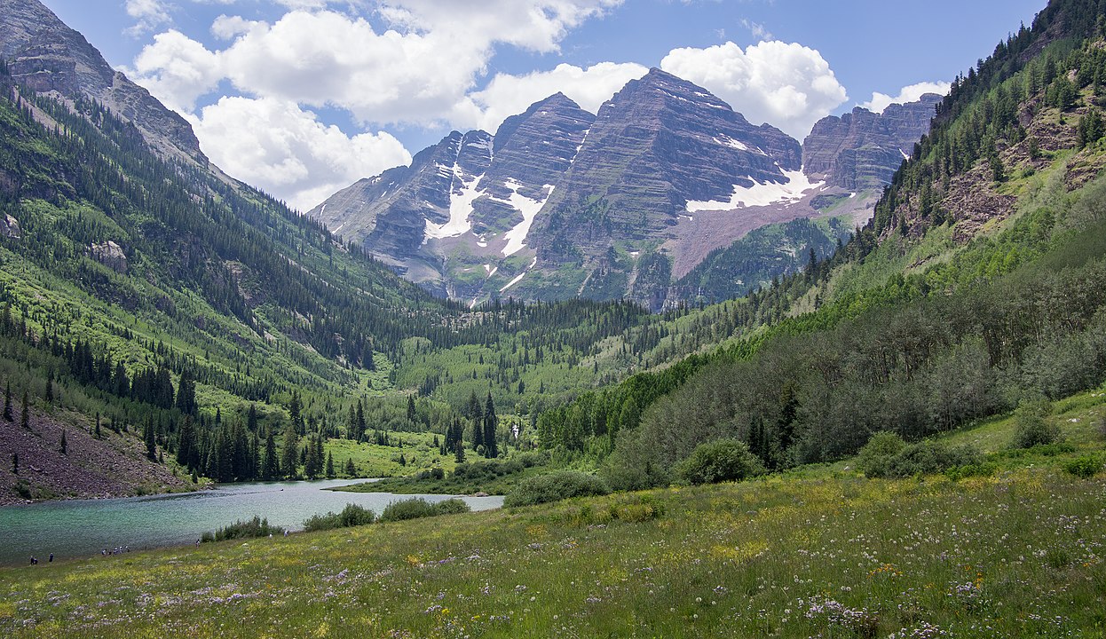
The Maroon Bells are two peaks in the Elk Mountains, Maroon Peak and North Maroon Peak, separated by about half a kilometer (0.3 miles). The mountains are on the border between Pitkin County and Gunnison County, Colorado, United States, about 19 kilometres (12 mi) southwest of Aspen. Both peaks are fourteeners. Maroon Peak, at 4,317 metres (14,163 ft), is the 27th highest peak in Colorado. North Maroon Peak, at 4,273 metres (14,019 ft), is the 50th highest (depending on how they are counted). The view of the Maroon Bells to the southwest from the Maroon Creek valley is very heavily photographed. The peaks are located in the Maroon Bells–Snowmass Wilderness of White River National Forest. Maroon Bells-Snowmass Wilderness was one of five areas in Colorado designated as wilderness in the original Wilderness Act of 1964. The Wilderness area surrounds the extremely popular Maroon Bells Scenic Area, which is a major access point for Wilderness travel. (Source: Wikipedia.org, CC BY-SA)
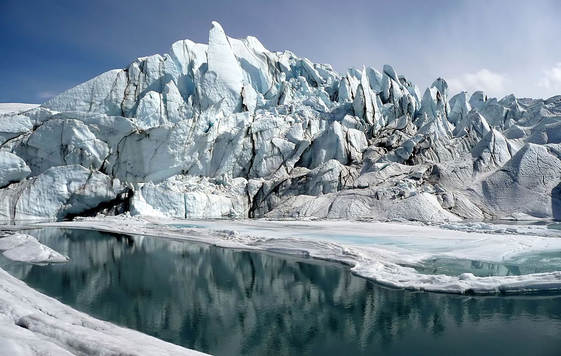
Matanuska Glacier is a valley glacier in the US state of Alaska. At 27 miles (43 km) long by 4 miles (6.4 km) wide, it is the largest glacier accessible by car in the United States. Its terminus feeds the Matanuska River. It lies near the Glenn Highway about 100 miles (160 km) northeast of Anchorage in Glacier View. The glacier flows about 1 foot (30 cm) per day. Due to ablation of the lower glacier, as of 2007, the location of the glacier terminus has changed little over the previous three decades. Nearby state park: An Alaska State Parks facility, the Matanuska Glacier State Recreation Site, is a 229-acre (93 ha) park with trails and a small campground. (Source: Wikipedia.org, CC BY-SA)
Mały Szyszak (Czech Malý Šišák, German Kleine Sturmhaube, literally Small Helmet) is a mountain on the border between the Czech Republic and Poland. It is situated in the central (Silesian) part of the main mountain range of the Giant Mountains, right above the villages Przesieka and Špindlerův Mlýn. It is separated from the mountain called Wielki Szyszak by Ptasi Kamień, Karkonoska Mountain Pass (Polish 'Przełęcz Karkonoska'), Śląskie Kamienie, Czeskie Kamienie and Śmielec. (Source: Wikipedia.org, CC BY-SA)
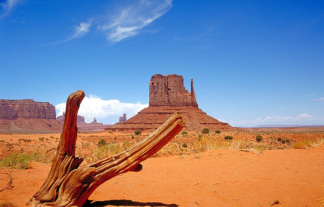
Monument Valley (Navajo: Tsé Biiʼ Ndzisgaii, pronounced [tsʰépìːʔ ǹtsɪ̀skɑ̀ìː], meaning valley of the rocks) is a region of the Colorado Plateau characterized by a cluster of sandstone buttes, the largest reaching 1,000 ft (300 m) above the valley floor. It is located on the Utah–Arizona state line, near the Four Corners area. The valley is a sacred area that lies within the territory of the Navajo Nation Reservation, the Native American people of the area. Monument Valley has been featured in many forms of media since the 1930s. Director John Ford used the location for a number of his Westerns; critic Keith Phipps wrote that 'its five square miles [13 km2] have defined what decades of moviegoers think of when they imagine the American West'. (Source: Wikipedia.org, CC BY-SA)
 © Wikimedia.org/Huebi, CC BY-DE
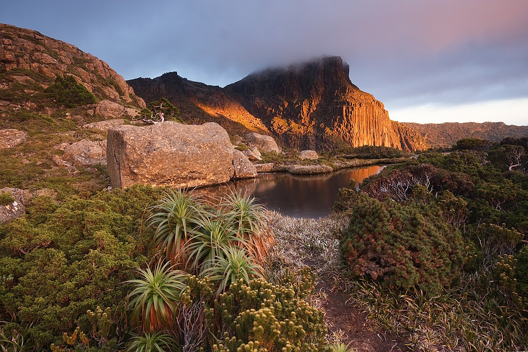
Mount Anne is a mountain located in the Southwest National Park in south-west region of Tasmania, Australia. The mountain lies within the UNESCO World Heritage-listed Tasmanian Wilderness. With an elevation of 1,423 metres (4,669 ft) above sea level, Mount Anne is within the forty highest mountains in Tasmania, and is the highest in south-west Tasmania, adding to its appearance of prominence. It dominates the area surrounding Lake Pedder. Although a primarily dolerite structure, it has a large sub-structure of dolomite, which contains an extensive cave system. This system includes the famous 'Anna-a-Kananda' cave — one of the deepest caves in Australia. Several cavers have been killed trying to explore its depths. Mount Anne has a superb region of ancient Gondwanan-type vegetation on its north-east ridge, some of which are amongst the oldest surviving plant species on the planet. (Source: Wikipedia.org, CC BY-SA)
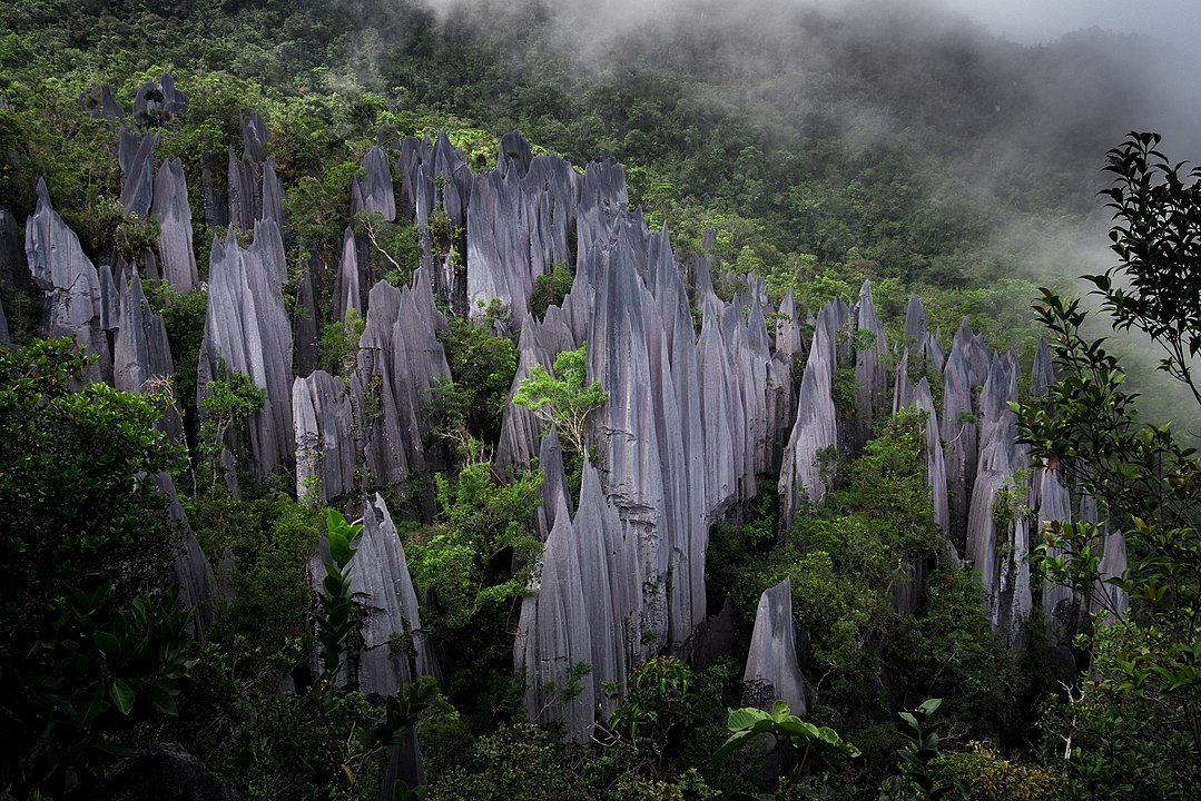
Mount Api (Malay: Gunung Api) is a limestone mountain located in Gunung Mulu National Park in Sarawak, Malaysia. Neighbouring Mount Benarat and Mount Buda are part of the same formation. Mount Api is famous for its striking limestone karst formations, commonly called 'the pinnacles'. The mountain is host to many caves, with passages linking to the massive Clearwater Cave system. Api Chamber, the second-largest chamber in Malaysia, was discovered on Mount Api during the Benarat 2005 Caving Expedition. (Source: Wikipedia.org, CC BY-SA)
 © Wikimedia.org/Nur Nafis Naim, CC BY-SA
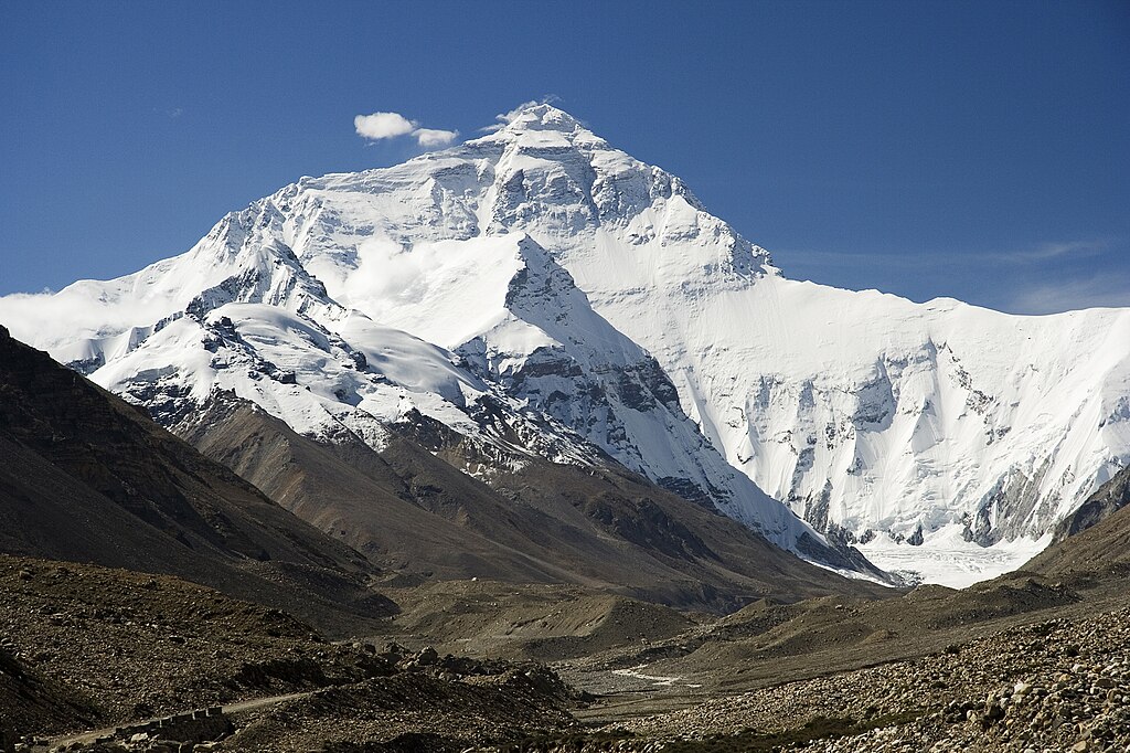
Mount Everest (Nepali: सगरमाथा, romanized: Sagarmāthā; Tibetan: Chomolungma ཇོ་མོ་གླང་མ; Chinese: 珠穆朗玛峰; pinyin: Zhūmùlǎngmǎ Fēng) is Earth's highest mountain above sea level, located in the Mahalangur Himal sub-range of the Himalayas. The China–Nepal border runs across its summit point. Its elevation (snow height) of 8,848.86 m (29,031 ft 8+1⁄2 in) was most recently established in 2020 by the Chinese and Nepali authorities. Mount Everest attracts many climbers, including highly experienced mountaineers. There are two main climbing routes, one approaching the summit from the southeast in Nepal (known as the 'standard route') and the other from the north in Tibet. While not posing substantial technical climbing challenges on the standard route, Everest presents dangers such as altitude sickness, weather, and wind, as well as hazards from avalanches and the Khumbu Icefall. As of November 2022, 310 people have died on Everest. Over 200 bodies remain on the mountain and have not been removed due to the dangerous conditions. (Source: Wikipedia.org, CC BY-SA)
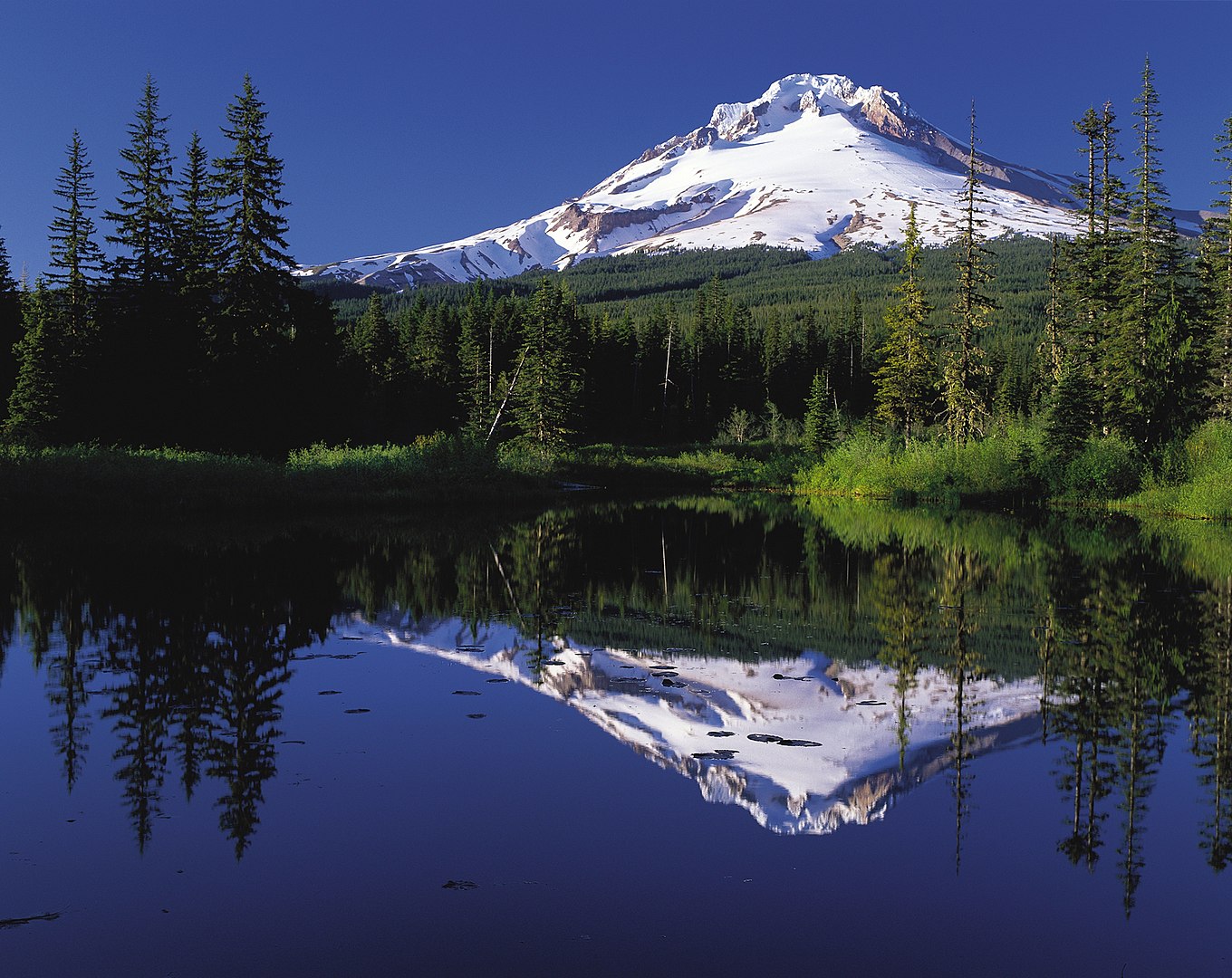
Mount Hood is a potentially active stratovolcano in the Cascade Volcanic Arc. It was formed by a subduction zone on the Pacific coast and rests in the Pacific Northwest region of the United States. It is located about 50 mi (80 km) east-southeast of Portland, on the border between Clackamas and Hood River counties. In addition to being Oregon's highest mountain, it is one of the loftiest mountains in the nation based on its prominence, and it offers the only year-round lift-served skiing in North America. (Source: Wikipedia.org, CC BY-SA)
 © Wikimedia.org/Mt. Hood Territory., CC0
Mount John Laurie is a mountain in the Canadian Rockies, located in Alberta's Municipal District of Bighorn No. 8. Standing at approximately 2,240 m (7,350 ft) above sea level, Mount John Laurie is the last mountain on the north side of the Bow River valley (Bow Valley) as it exits the mountains for the foothills and prairie of Alberta. Located close to Calgary, it is a popular 'great scramble'[further explanation needed]. It is also a popular rock climbing destination, with over 100 routes of all difficulty levels spread out across its face. Standing at approximately 2,240 m (7,350 ft) above sea level, Mount John Laurie is the last mountain on the north side of the Bow River valley (Bow Valley) as it exits the mountains for the foothills and prairie of Alberta. Located close to Calgary, it is a popular 'great scramble'[further explanation needed]. It is also a popular rock climbing destination, with over 100 routes of all difficulty levels spread out across its face. (Source: Wikipedia.org, CC BY-SA)
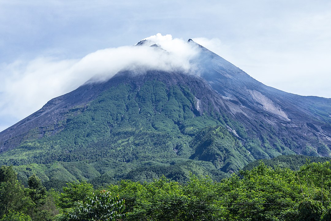
Mount Merapi, Gunung Merapi (literally Fire Mountain in Indonesian and Javanese), is an active stratovolcano located on the border between the province of Central Java and the Special Region of Yogyakarta, Indonesia. It is the most active volcano in Indonesia and has erupted regularly since 1548. It is located approximately 28 km (17 mi) north of Yogyakarta city which has a population of 2.4 million, and thousands of people live on the flanks of the volcano, with villages as high as 1,700 m (5,577 ft) above sea level. Smoke can often be seen emerging from the mountaintop, and several eruptions have caused fatalities. A pyroclastic flow from a large explosion killed 27 people on 22 November 1994, mostly in the town of Muntilan, west of the volcano. Another large eruption occurred in 2006, shortly before the Yogyakarta earthquake. In light of the hazards that Merapi poses to populated areas, it was designated as one of the Decade Volcanoes. (Source: Wikipedia.org, CC BY-SA)
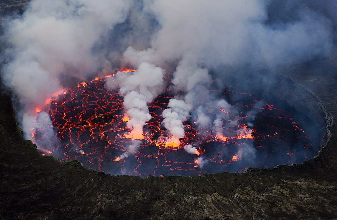
Mount Nyiragongo (/ˌnɪərəˈɡɒŋɡoʊ, -ˈɡɔːŋ-/ neer-ə-GONG-go) is an active stratovolcano with an elevation of 3,470 m (11,385 ft) in the Virunga Mountains associated with the Albertine Rift. It is located inside Virunga National Park, in the Democratic Republic of the Congo, about 12 km (7.5 mi) north of the town of Goma and Lake Kivu and just west of the border with Rwanda. The main crater is about two kilometres (1 mi) wide and usually contains a lava lake. The crater presently has two distinct cooled lava benches within the crater walls – one at about 3,175 m (10,417 ft) and a lower one at about 2,975 m (9,760 ft). (Source: Wikipedia.org, CC BY-SA)
 © Wikimedia.org/Cai Tjeenk Willink, CC BY-SA
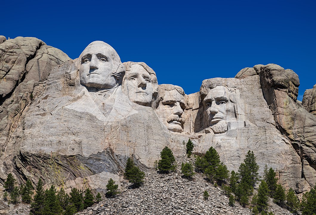
The Mount Rushmore National Memorial is a national memorial centered on a colossal sculpture carved into the granite face of Mount Rushmore (Lakota: Tȟuŋkášila Šákpe, or Six Grandfathers) in the Black Hills near Keystone, South Dakota, United States. Sculptor Gutzon Borglum designed the sculpture, called Shrine of Democracy, and oversaw the project's execution from 1927 to 1941 with the help of his son, Lincoln Borglum. The sculpture features the 60-foot-tall (18 m) heads of four United States presidents: George Washington (1732–1799), Thomas Jefferson (1743–1826), Theodore Roosevelt (1858–1919) and Abraham Lincoln (1809–1865). Mount Rushmore attracts more than two million visitors annually. The four presidents were chosen to represent the nation's birth, growth, development and preservation, respectively. The memorial park covers 1,278 acres (2.00 sq mi; 5.17 km2) and the mountain's elevation is 5,725 feet (1,745 m) above sea level. (Source: Wikipedia.org, CC BY-SA)
Mount Tarawera is a volcano on the North Island of New Zealand within the older but volcanically productive Ōkataina Caldera. Located 24 kilometres southeast of Rotorua, it consists of a series of rhyolitic lava domes that were fissured down the middle by an explosive basaltic eruption in 1886. This eruption was one of New Zealand's largest historical eruptions, and killed an estimated 120 people. The fissures run for about 17 kilometres (11 mi) northeast-southwest. The volcano's component domes include Ruawahia Dome (the highest at 1,111 metres), Tarawera Dome and Wahanga Dome. It is surrounded by several lakes, most of which were created or drastically altered by the 1886 eruption. (Source: Wikipedia.org, CC BY-SA)
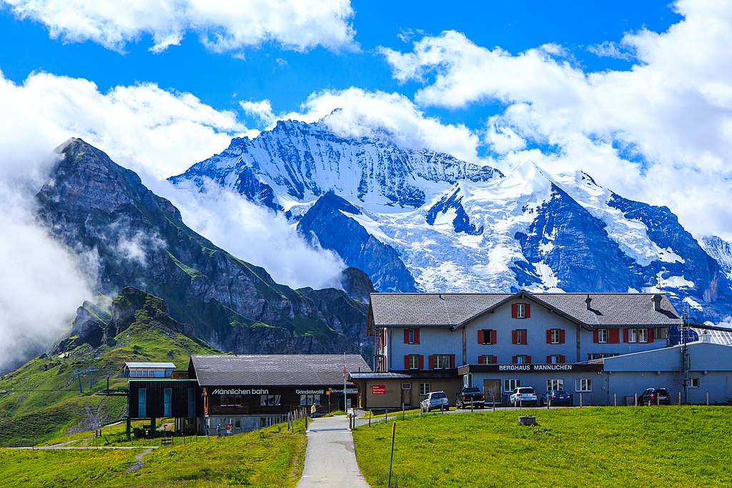
The Männlichen is a 2,343-metre (7,687 ft) mountain in the Swiss Alps located within the Canton of Berne. It can be reached from Wengen by the Wengen–Männlichen aerial cableway, or from the new (December 2019) Grindelwald Terminal station using the Grindelwald–Männlichen gondola cableway (GM). It then takes 15 minutes to walk to the summit. It is a popular viewpoint over the Lauterbrunnen valley and a popular start location for hikers and skiers. (Source: Wikipedia.org, CC BY-SA)
Noordhoek is a seaside town in the Western Cape, South Africa, located below Chapman's Peak on the west coast of the Cape Peninsula and is approximately 35 kilometres (22 mi) to the south of Cape Town. The name 'Noordhoek' was taken from Dutch and literally means 'north corner'. It was given this name in 1743 as being the northern corner of the Slangkop farm. The first permanent resident of European origin is Jaco Malan who built his house there. In 1857, the region was divided into six plots, most of which were bought by a single family, that of the de Villiers. Noordhoek nevertheless remains a predominantly rural area where farmers grow vegetables to supply ships calling at Simon's Town. It is best known for its shoreline and its long, wide, sandy beach, which stretches south to the neighbouring village of Kommetjie. Near the southern end of this beach is the wreck of the steamship 'Kakapo', which ran aground in 1900, when the captain mistook Chapman's Peak for the Cape of Good Hope and put the helm over to port. (Source: Wikipedia.org, CC BY-SA)
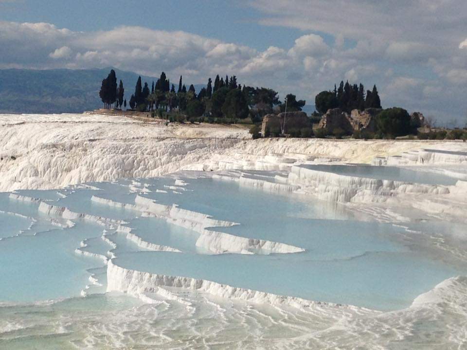
Pamukkale, meaning 'cotton castle' in Turkish, is a natural site in Denizli Province in southwestern Turkey. The area is famous for a carbonate mineral left by the flowing of thermal spring water. It is located in Turkey's Inner Aegean region, in the River Menderes valley, which has a temperate climate for most of the year. The ancient Greek city of Hierapolis was built on top of the travertine formation which is in total about 2,700 metres (8,860 ft) long, 600 m (1,970 ft) wide and 160 m (525 ft) high. It can be seen from the hills on the opposite side of the valley in the town of Denizli, 20 km away. This area has been drawing visitors to its thermal springs since the time of classical antiquity. The Turkish name refers to the surface of the shimmering, snow-white limestone, shaped over millennia by calcite-rich springs. Dripping slowly down the mountainside, mineral-rich waters collect in and cascade down the mineral terraces, into pools below. (Source: Wikipedia.org, CC BY-SA)
 © Wikimedia.org/Emre KOYUNCUOĞLU, CC BY-SA

Time for recess! Post a comment, ask a question or write a review. Feel free to let us know what you think!
look at the sign on the road to avoid accidents and horrible driving conditions
 -3
-3
I received a 300$ ticket because I passed a police control of other cars/drivers on the right lane of a highway (the control was on the hard shoulder of the highway). Is it really true, that you have to change the lane in such cases? Thanks!
I am an American living in Italy. The Italian Drivers License theory test is the hardest test I have ever studied for and I am in my 70s have multiple degrees, multiple professional certifications. Have to take the Italian Drivers Theory test in Italian. No english. So many rules. More signs in small medieval Italian town I live in then in major US cities I have lived in. No Italian license no driving. No buying or renting a car. Test here was good, clean. Lots of tricky questions on many practice and real official tests. Thanks
Most problems are a result of higher than safe driving speeds. Please just slow down and be patient.
Question 121: Poor translation: Vehicles with polluted fluids prohibited Should be translated as: Vehicles with dangerous liquids prohibited
Question 83: Poor translation: Vehicles with polluted fluids prohibited Should be translated as: Vehicles with dangerous liquids prohibited
0
Want even more practice? Visit similar websites offering realistic practice driving knowledge tests. Visit us to see what sets our tests apart! https://dkttest.com/capital-territory/
Cool tool! And fun to check whether I remember the rules :) Two things I noticed: Warning for a crossroad side roads on the left and right. While technically that might be the correct translation, this sign tells you, that you are on the main road and have the right of way for the next crossroad and only the next crossroad. Usually (if no sign specifies otherwise) you have to give way to drivers coming from the right at every intersection, which can get a bit annoying in communal areas, so seeing this sign feels less like a warning and more like relief :). A Fahrradstraße is not a lane for cyclists but a street for cyclists, meaning the (whole!) street is intended predominantly for cyclists, who are then allowed to ride next to each other. Cars are allowed to drive there (unless another sign prohibits such), but have to adjust their speed to the cyclists. I believe they are not allowed to pass at all, even if the oncoming lane is empty.


More community